A 50-Degree Temperature Split Is Happening Right Now Along the East Coast as the Northeast Sits in the 30s While the Coastal Plain Bakes in the 80s and a Sharp Seasonal Boundary Snakes From the Midwest Through New England
UNITED STATES — One of the most dramatic temperature contrasts of the spring season is unfolding along the East Coast right now, Wednesday morning, April 1, 2026. A sharp seasonal boundary snaking from the Midwest through the Northeast is creating a jarring 50-degree temperature split across a relatively narrow geographic corridor — with the Northeast sitting in the 30s while the coastal plain from Georgia through the Carolinas and Virginia basks in the 80s simultaneously. Just behind the boundary, temperatures have crashed dramatically — with Minnesota, Wisconsin, and the Upper Great Lakes recording some of the most significant morning temperature drops seen this spring.
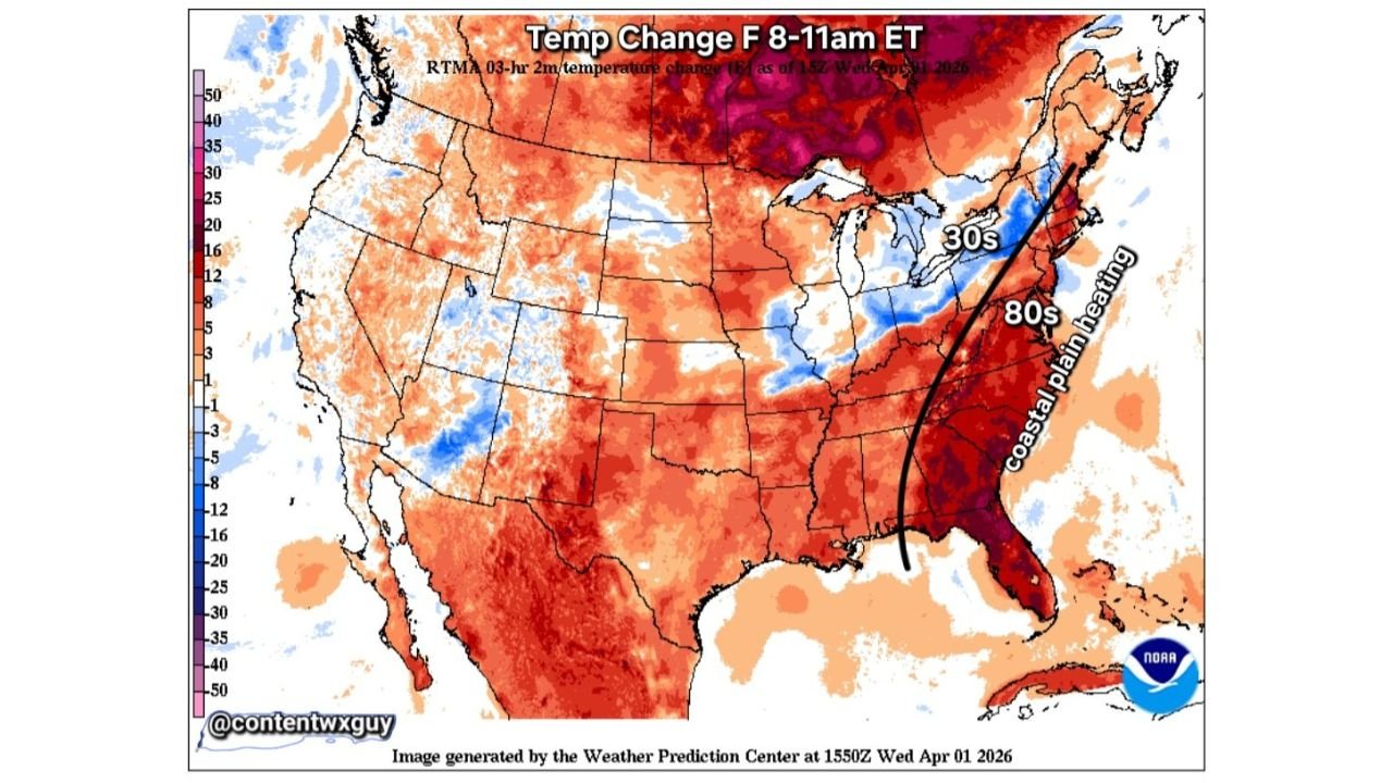
This analysis is based on the NOAA Weather Prediction Center RTMA 3-hour temperature change data valid Wednesday, April 1, 2026 at 15z — reflecting the 8 to 11 AM ET morning period.
The Boundary That Is Splitting the East Coast
A seasonal level boundary — the meteorological term for the sharp dividing line between a cold air mass and a warm air mass — is currently draped from the Midwest southeastward through the Great Lakes and into the Northeast. This boundary is not a gradual transition zone. It is a sharp, well-defined line where temperatures on one side are dramatically different from temperatures just miles away on the other side.
On the cold side of the boundary — across New England, the Mid-Atlantic coast, and the Great Lakes — temperatures this morning are running in the 30s along the immediate coast and into the 40s across interior areas. Cold air that has surged southward from Canada behind a strong frontal passage is holding firm across this region, keeping temperatures well below where they were just 24 to 48 hours ago.
On the warm side of the boundary — across the coastal plain from Georgia through South Carolina, North Carolina, and Virginia — Atlantic high pressure return flow is pumping warm, moist air northward from the Gulf and Atlantic, keeping temperatures in the 80s along the coastal plain this morning. This is the same Atlantic high pressure system that has kept the Southeast warm and humid ahead of the approaching cold air, and its influence is still being felt strongly across the coastal plain Wednesday morning.
The result is a temperature difference of roughly 50 degrees between the two sides of this boundary — with 30s in Connecticut and Massachusetts and 80s in Georgia and South Carolina existing simultaneously on the same Wednesday morning.
The Minnesota and Great Lakes Temperature Crash
The most dramatic temperature change this morning is not along the boundary itself — it is well behind it, across Minnesota, Wisconsin, and the Upper Great Lakes.
The RTMA 3-hour temperature change map shows deep purple and magenta colors across Minnesota and Wisconsin this morning — representing temperature drops of 30 to 50 degrees in just a three-hour window from 8 to 11 AM ET. This is the signature of cold air crashing southward behind a fast-moving and potent frontal boundary — temperatures that were relatively mild overnight collapsing dramatically as Arctic air pours in from Canada.
For communities across Minnesota and Wisconsin, this morning’s temperature crash represents the sharp end of the same boundary that is creating the 50-degree split further east. What the Northeast will experience gradually over the next 24 to 48 hours, the Upper Midwest is experiencing right now — rapidly and dramatically.
Coastal Plain Heating — The Atlantic High Pressure Factor
The warm side of Wednesday’s temperature contrast is being actively maintained by a specific and identifiable atmospheric mechanism — Atlantic high pressure return flow.
When a strong high pressure system sits off the Atlantic coast, it generates a clockwise circulation that pulls warm, moist air from the south and southwest across the coastal plain states. This return flow effectively acts as a warm air conveyor belt — continuously replacing any air that tries to cool with fresh warm air transported northward from the Gulf Coast and Atlantic waters.
The coastal plain from northern Florida through Georgia, South Carolina, North Carolina, and into Virginia is sitting directly in the path of this return flow Wednesday morning — which is why temperatures along this narrow coastal corridor remain in the 80s even as cold air has already pushed into the Northeast and is approaching from the northwest.
This contrast — 30s in New England vs 80s on the coastal plain — will not last much longer. The cold boundary is moving and the Atlantic high pressure return flow will eventually be overrun by the approaching cold air mass. But for Wednesday morning, the split is real, dramatic, and meteorologically striking.
Temperature Change Summary — Wednesday Morning April 1
| Region | Temperature Change 8-11 AM | Current Conditions |
|---|---|---|
| Minnesota / Wisconsin | -30 to -50°F in 3 hours | Cold air crashing in — dramatic crash |
| Upper Michigan / Great Lakes | -12 to -25°F | Significant cooling underway |
| New England coast | -8 to -16°F | Temperatures in the 30s |
| Mid-Atlantic / New York | -5 to -12°F | Cooling rapidly |
| Georgia / Carolina coastal plain | +5 to +12°F | Still warming — 80s |
| Virginia coastal plain | Warming slightly | Transition zone |
| Plains / Southwest | +5 to +20°F | Continued warming |
Why This Boundary Matters for Severe Weather
The seasonal boundary currently snaking from the Midwest to the Northeast is not just a temperature curiosity — it is a direct contributor to the active and dangerous severe weather pattern that has defined this week across the central United States.
Sharp temperature boundaries like this one are the building blocks of severe weather. The contrast between the cold air behind the boundary and the warm, moist air ahead of it creates atmospheric instability — the fuel that powers thunderstorms and severe weather development. The sharper and more well-defined the boundary, the more concentrated the instability along it — and the more organized and intense the severe weather that can develop along its leading edge.
The same boundary that is producing 30s in New England this morning while the Southeast sits in the 80s is the boundary that has been triggering tornado-producing supercells across Oklahoma, Kansas, Iowa, and Illinois throughout this week’s historic severe weather pattern. Wednesday’s temperature contrast map is a visual snapshot of the atmospheric engine that has been driving one of the most active severe weather weeks in recent memory.
Forecast Confidence Level
High confidence on the temperature contrast across the East Coast Wednesday morning — the RTMA data is observational, not forecast-based, meaning this split is actually occurring right now.
High confidence on the Atlantic high pressure return flow maintaining coastal plain warmth through Wednesday** — the high pressure system is well-positioned and its influence on coastal plain temperatures is clearly evident in the morning data.
High confidence on the Minnesota and Wisconsin temperature crash** — the RTMA clearly shows the dramatic 3-hour temperature drop across the Upper Midwest this morning.
What This Means for Residents on Both Sides of the Boundary
New England and Mid-Atlantic residents sitting on the cold side of the boundary this morning should dress for genuine late-winter conditions — temperatures in the 30s with wind chill values potentially making it feel colder. The dramatic warmth of the past week is gone for now, replaced by the same cold air mass that has been crashing southward across the Midwest all week.
Coastal plain residents from Georgia through the Carolinas and Virginia are enjoying what may be one of the last mornings of 80-degree warmth before the cold boundary eventually pushes through. The Atlantic high pressure return flow keeping you warm this morning will be overrun by the approaching cold air — enjoy the warmth but prepare for a significant temperature change in the coming days.
Minnesota and Wisconsin residents are experiencing the sharpest end of this boundary right now — with temperatures dropping 30 to 50 degrees in just a few hours this morning. This is the most rapid cold air intrusion of the week and signals the arrival of genuine late-season cold across the Upper Midwest.
The Bottom Line
A dramatic 50-degree temperature split is unfolding along the East Coast Wednesday morning — with the Northeast sitting in the 30s and the coastal plain baking in the 80s simultaneously as a sharp seasonal boundary snakes from the Midwest through New England. Behind the boundary, Minnesota and Wisconsin are recording temperature drops of 30 to 50 degrees in just three hours as Arctic air crashes southward. Atlantic high pressure return flow is maintaining the anomalous warmth along the coastal plain — but the cold boundary is moving and the contrast will not last. This temperature split is the same atmospheric boundary that has been driving one of the most active and historic severe weather weeks across the central United States all week long.
Stay ahead of dramatic weather changes before they reach your door. Visit cabarrusweekly.com for daily temperature analysis, severe weather coverage, and forecast updates from across the United States — because knowing early is the difference that matters.