After Record Warmth Across Texas, the Midwest and the East Coast, Models Show Sharp Mid-March Cooldown Spreading From the Northern Plains to the Great Lakes and Ohio Valley
UNITED STATES — After one of the warmest opening stretches of March in recent memory across much of the central and eastern United States, new model guidance is signaling a dramatic reversal by mid-month, with significantly colder air plunging southward into the Northern Plains, Upper Midwest and Great Lakes.
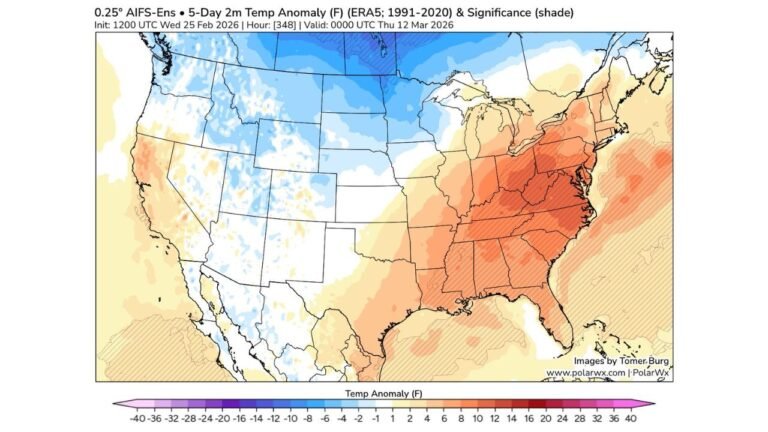
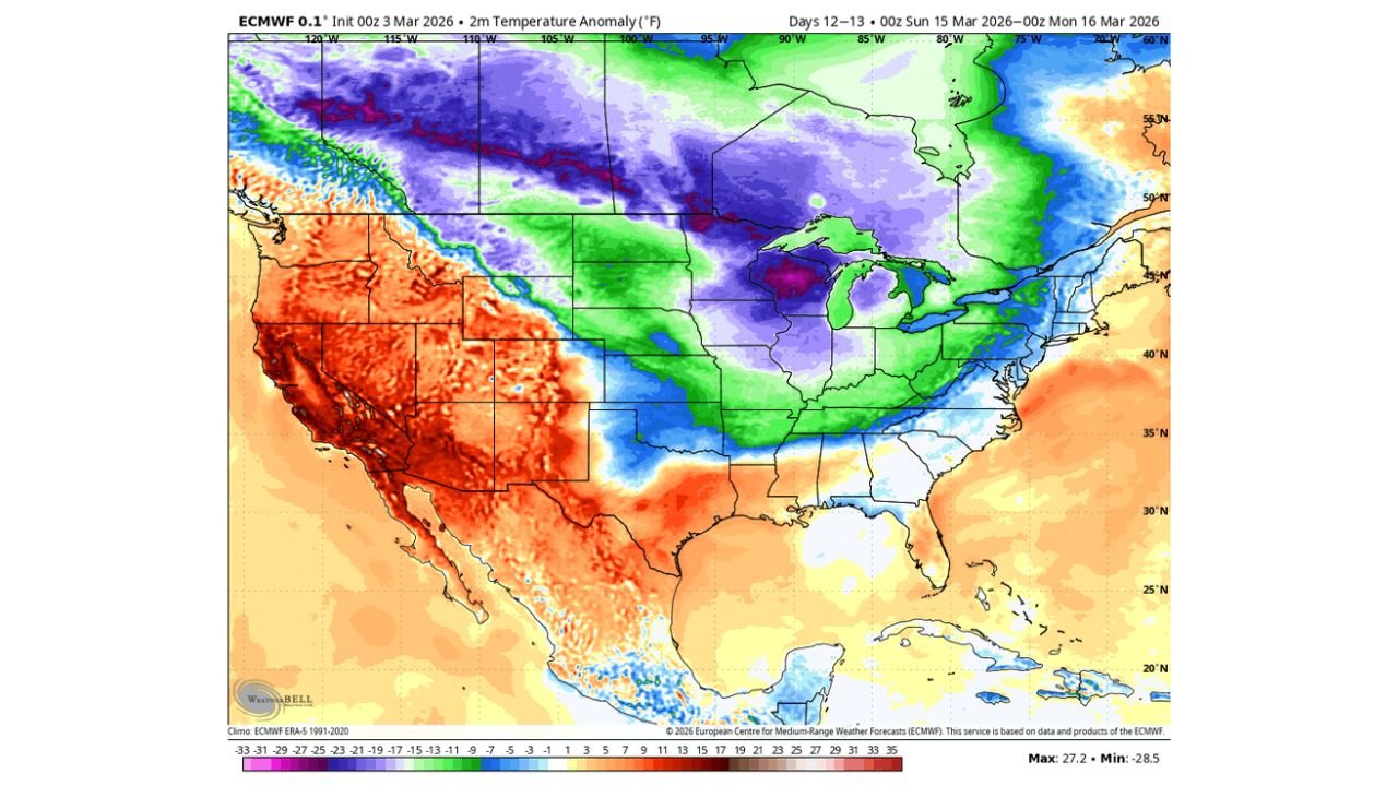
Forecast anomaly maps show a striking contrast between early March warmth and what could unfold around March 12–16.
Early March: Widespread Warmth From Texas to the East Coast
During the first 10 days of March, temperatures are projected to run well above average across:
- Texas
- Oklahoma
- Kansas
- Missouri
- Illinois
- Indiana
- Ohio
- Kentucky
- Tennessee
- Much of the Mid-Atlantic and Northeast
Temperature anomaly maps show large areas shaded deep red across the Midwest and East, indicating departures significantly above normal. The core of the warmth stretches from the Southern Plains through the Ohio Valley and into the Great Lakes region.
This pattern supports early spring-like conditions, with highs running far above seasonal averages in many cities.
Mid-March Flip: Colder Air Surges South
By roughly March 12–16, forecast guidance shows a notable pattern shift.
Colder-than-average air spreads across:
- North Dakota
- South Dakota
- Minnesota
- Wisconsin
- Michigan
- Iowa
- Nebraska
- Parts of Illinois and Indiana
- Portions of the Ohio Valley
Blues and purples dominate the anomaly map across the northern and central U.S., signaling temperatures running below seasonal norms.
The coldest anomalies appear centered over the Upper Midwest and northern Plains, where departures from normal could be substantial.
Sharp Temperature Gradient Across the U.S.
While colder air pushes into the northern and central states, warmth may persist across:
- California
- The Desert Southwest
- Portions of Arizona and Nevada
- Parts of the Deep South
This creates a pronounced west-to-east and north-to-south contrast, with much colder conditions over the north-central U.S. and warmer air lingering farther south and west.
What This Means
The same areas experiencing well-above-normal temperatures in early March — particularly across the Midwest and parts of the East — could see a sharp reversal by mid-month.
If current trends hold:
- The Great Lakes region
- The Upper Midwest
- Portions of the Northern Plains
- Parts of the Ohio Valley
May transition from spring-like warmth to a more winter-like feel within a matter of days.
Forecast confidence on exact magnitude and placement will continue to evolve, but model agreement is increasing that a meaningful mid-March cooldown is on the table.
CabarrusWeekly.com will continue to monitor this developing pattern and provide updates as confidence increases in the timing and intensity of the cold surge.