AI Forecast Models Signal Major I-95 Winter Storm With 978 mb Coastal Low and Heavy Snow From Washington, D.C. to Boston
EAST COAST — Advanced AI-based forecast models are increasingly pointing toward a potentially significant winter storm along the I-95 corridor, with a deep coastal low and widespread snowfall from the Mid-Atlantic into New England.
Recent guidance indicates a 978 mb low pressure system developing off the Mid-Atlantic coast and intensifying as it tracks northeast. The projected setup would place major population centers from Washington, D.C. to Philadelphia, New York City, and Boston in a zone of heavy precipitation and strong winds.
Deep Coastal Low Drives Wind and Snow
Model projections show a tightly wound surface low off the Delmarva Peninsula, with strong onshore flow and tight pressure gradients extending inland.
This configuration would promote gusty winds along the coast, including areas of New Jersey, Long Island, and southern New England, while also enhancing lift across the interior.
Wind fields wrapping into the system suggest potential for blowing snow and reduced visibility if heavier bands materialize.
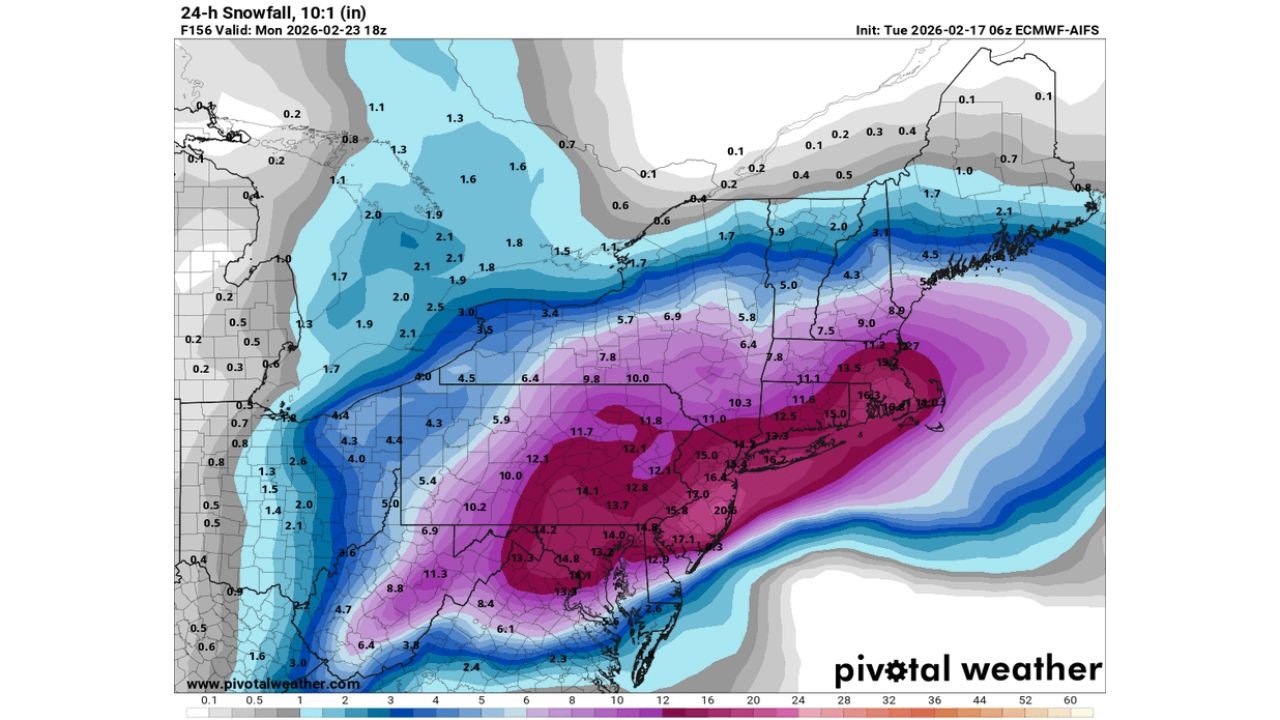
Heavy Snow Signal Along and Just Inland of I-95
Snowfall guidance highlights a pronounced band of accumulation stretching from northern Virginia through Maryland, Pennsylvania, New Jersey, southeastern New York, Connecticut, Rhode Island, and into Massachusetts.
The most aggressive projections show a corridor of double-digit snowfall totals, particularly inland from the immediate shoreline. Portions of central and northern New Jersey, eastern Pennsylvania, the lower Hudson Valley, and interior southern New England appear positioned in the heavier swath.
Some projections indicate totals exceeding 12 inches, with localized higher amounts where banding sets up.
Colder Look Along the I-95 Corridor
One key difference emerging in the latest AI guidance is a colder solution along the I-95 corridor, increasing the probability that precipitation falls predominantly as snow rather than mixing with rain.
This colder scenario would shift the rain/snow line closer to the coast, potentially allowing heavier accumulations to extend into metro areas including New York City and Boston, depending on exact storm track and thermal profiles.
Small adjustments in the low’s position will significantly influence snowfall totals and precipitation type.
Model Differences Still Present
While multiple AI-based runs are showing a similar storm scenario, there are still notable differences between initialization times. Some model cycles appear more aggressive, while others show subtle suppression or track shifts.
That variability means confidence is increasing in a storm signal, but exact placement of the heaviest snow band remains uncertain.
A westward shift would increase snowfall in major coastal cities, while an eastward adjustment would limit accumulations closer to the shoreline.
What to Watch Moving Forward
The key factors over the next several model cycles will include:
Track of the coastal low
Thermal profiles along I-95
Placement of mesoscale snow bands
If the colder solution verifies, this system could deliver significant winter impacts to millions along the East Coast early next week.
Residents from Washington, D.C. to Boston should closely monitor forecast updates as confidence continues to build.
If you live along the I-95 corridor, now is the time to review winter preparedness plans and stay tuned for updated projections. Share your local forecast thoughts and observations with CabarrusWeekly.com as this potential coastal storm develops.