AI Weather Models Hint at Potential Mid-Atlantic and Northeast Winter Storm This Weekend as Track Differences Raise Rain-Snow Line Questions
MID-ATLANTIC — A potential late-weekend winter system is drawing growing attention across the Mid-Atlantic and Northeast, as several artificial intelligence–based weather models signal a developing coastal low that could bring a mix of rain and snow by early Monday, February 23.
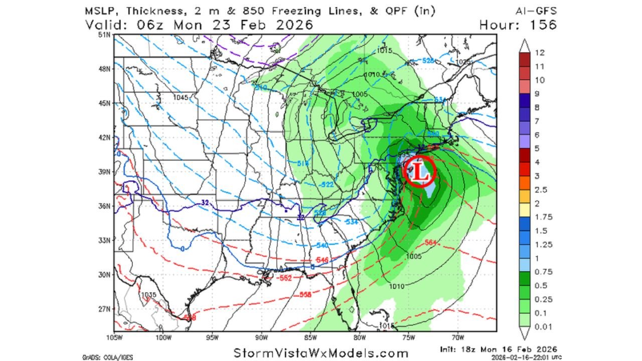
While it is far from a locked-in forecast, the latest 18z model runs show increasing agreement among some AI-guided systems that a surface low may organize near the Southeast coast before tracking northeastward offshore.
AI Models Lead the Charge on Storm Signal
The latest runs of Google WeatherNEXT, AI-GFS, AI European (AIFS), and AIFS-ENS all depict some form of coastal low pressure developing near the Carolinas and moving toward the Delmarva Peninsula and offshore of New Jersey.
In several solutions, a strengthening low appears positioned just east of the North Carolina and Virginia coastline before intensifying off the Mid-Atlantic coast.
However, traditional operational physics-based models — including the operational European model — are less enthusiastic, in some cases suppressing the system farther offshore or weakening it considerably.
That divide between AI-driven output and legacy guidance remains one of the biggest forecast questions heading into the weekend.
Track Will Determine Snow vs. Rain
Most AI solutions suggest precipitation spreading northward into portions of:
- Eastern North Carolina
- Virginia
- Maryland
- Delaware
- New Jersey
- Southern Pennsylvania
- New York
But temperature profiles appear marginal, especially near the coast and across the Washington, D.C. region.
Forecast thickness lines and freezing-level projections show a rain/snow battle zone across parts of Virginia and Maryland, where a small shift in the storm’s track could determine whether areas see:
- Mostly rain
- A wet snow accumulation
- Or a disruptive wintry mix
Farther inland — particularly into interior Pennsylvania and upstate New York — colder air is more established, increasing the potential for accumulating snow if precipitation reaches that far north.
Not a Classic Blizzard Setup
Despite the increasing model chatter, the overall pattern does not currently resemble a classic major blizzard scenario.
Upper-level flow and temperature gradients suggest this would more likely be a moderate, potentially disruptive winter storm rather than a widespread, crippling event.
Wind fields are supportive of a strengthening coastal low, but the key limiting factor remains how far west meaningful moisture can wrap before dry air intrudes.
If the storm tracks slightly farther east, much of the I-95 corridor could see lighter precipitation and more mixed precipitation rather than heavy snow.
Confidence Still Limited
Ensemble guidance (AIFS-ENS) shows broader spread, with some members favoring a more suppressed solution offshore and others closer to the coast.
This range of outcomes highlights that confidence remains moderate at best.
The next several model cycles will be critical in determining:
- Whether moisture expands inland
- How strong the low ultimately becomes
- And where the rain/snow line sets up
For now, residents across the Mid-Atlantic and Northeast should monitor updates throughout the week as model trends continue to evolve.
CabarrusWeekly.com will continue tracking forecast adjustments and provide updates as clarity improves heading into the weekend.