“All-Hazard” Severe Weather Zone Expands Across Illinois, Indiana, Kentucky and Tennessee With Damaging Winds, Hail and Tornado Risk
INDIANA — A widespread severe weather setup is taking shape across the lower Midwest and Ohio Valley, with a large “all-hazard” risk zone highlighting the potential for tornadoes, damaging winds, large hail, and heavy rainfall.
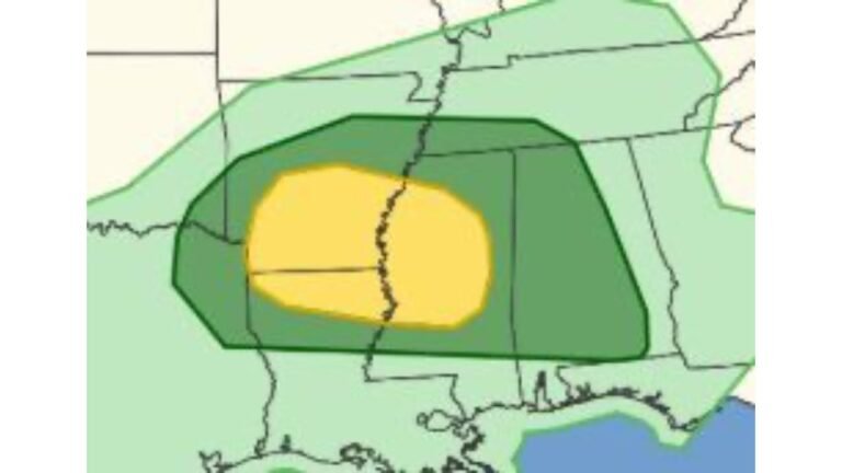
The highlighted yellow area stretches from central and southern Illinois across much of Indiana and into central Kentucky, while a broader green risk surrounds it, extending into parts of Tennessee and Ohio. This signals an environment supportive of multiple severe threats rather than just one isolated hazard.
Core Risk Zone Centered on Indiana and Kentucky
The most concentrated risk appears across central and southern Indiana, including Bloomington and areas near Indianapolis, extending south into Louisville and much of central Kentucky, and west into southern Illinois near St. Louis and Hillsboro.
Cities within or near the highlighted zone include:
- Bloomington, IN
- Indianapolis, IN
- Louisville, KY
- Evansville, IN
- Cincinnati, OH (near the eastern edge)
This area is labeled as an “all-hazard” zone, meaning atmospheric conditions could support several types of severe weather simultaneously.
Tornado Potential Cannot Be Ruled Out
The placement of the enhanced risk over Indiana and Kentucky suggests favorable wind shear and instability overlapping. That combination raises concern for rotating thunderstorms capable of producing tornadoes, especially in the more concentrated yellow zone.
While not every storm will produce a tornado, the environment supports the possibility of embedded supercells or line-embedded circulations, particularly during peak heating or as storms organize into clusters.
Damaging Winds and Large Hail Also Likely
Beyond tornado risk, the broader setup supports:
- Damaging straight-line wind gusts
- Large hail in stronger updrafts
- Locally heavy rainfall
With such a wide coverage area, severe storms may evolve into organized clusters or lines capable of producing widespread wind impacts, especially across central Indiana, western Kentucky, and southern Illinois.
Tennessee and Surrounding Areas in Broader Risk
The green-shaded surrounding area includes portions of Tennessee, southern Illinois, and western Ohio, indicating that severe storms remain possible outside the core zone.
Cities such as Clarksville, TN and areas north of Nashville sit within the broader outlook. While the highest probabilities are centered farther north, conditions remain supportive of strong thunderstorms across this wider region.
Timing and What to Watch
Key elements to monitor include:
- Storm development along frontal boundaries
- Rapid intensification during afternoon or evening hours
- Any shift in the highest-risk zone north or south
Because this is an “all-hazard” environment, impacts may vary by location — some communities may experience mainly wind, while others could see hail or isolated tornadoes.
Residents across Illinois, Indiana, Kentucky, and Tennessee should remain weather-aware and be prepared for rapidly changing conditions.
We will continue monitoring this setup closely. If severe weather develops in your area, share your conditions and updates with us at CabarrusWeekly.com as we track this evolving situation.