April 6–10 Timeline: Heavy Rain Targets Midwest and Florida While Northern Drought Zones Miss Out on Relief
UNITED STATES — A developing weather pattern heading into the second week of April is setting up a split-impact scenario across the country, where some regions could see meaningful rainfall and drought relief, while others—especially in the north—remain largely dry.
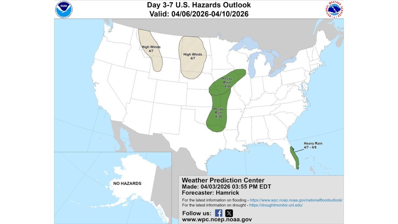
The latest hazard outlook for April 6 through April 10 highlights a stalled frontal boundary and potential low-pressure development that will focus heavier rain across parts of the Midwest and Florida, but leave northern drought-stricken areas with limited improvement.
Where Heavy Rain Is Expected to Develop
Forecast guidance shows two primary zones of concern:
- Midwest Corridor (April 9–10):
A concentrated area stretching from eastern Kansas and Missouri into Illinois, Iowa, and toward the western Great Lakes is expected to see periods of heavy rainfall, especially mid to late week. - Florida Peninsula (April 7–8):
A stalled boundary combined with moisture from the Gulf and Atlantic will bring rounds of rain and thunderstorms, with localized heavier totals possible along the peninsula.
These regions stand the best chance of seeing noticeable rainfall accumulation, which could provide short-term drought relief, particularly in areas that have been running below normal precipitation.
Why This Pattern Is Setting Up
The key driver behind this setup is a slow-moving or stalled front, which allows moisture to pool and rainfall to persist over the same areas.
- A potential low-pressure system developing along the boundary could further enhance rainfall totals
- Moisture transport from the Gulf will feed into both the Midwest and Southeast corridors
- The slow movement increases the chance for multi-day rainfall events rather than quick-moving storms
This type of pattern is often associated with efficient rainfall production, meaning totals can add up quickly even without severe storms.
Northern Areas Continue to Miss Significant Rainfall
Despite the promising setup elsewhere, northern portions of the country—especially areas already dealing with entrenched drought—are not expected to benefit much from this system.
- Much of the northern Plains and upper Midwest remain outside the heaviest rain zones
- Rainfall, if it occurs, will likely be lighter and less consistent
- This could prolong ongoing drought concerns in those regions
This uneven distribution highlights a frustrating reality: not all drought zones receive relief at the same time, even during active weather patterns.
Additional Hazard Signals Across the U.S.
Beyond rainfall, the outlook also points to:
- High wind potential across parts of the northern Plains (around April 7)
- Continued active weather signals in the central U.S., though the main concern remains rainfall rather than severe storms
No major hazards are indicated for Alaska during this period.
What This Means Going Into Mid-April
This upcoming stretch represents a transition period in the broader weather pattern, with increasing moisture and activity across central and eastern parts of the country.
- Some areas will see beneficial rain and temporary drought relief
- Others, particularly in the north, may continue to wait for meaningful precipitation
- The pattern could remain active beyond this window, depending on how the system evolves
Stay Updated With Cabarrus Weekly
For continued updates on developing rainfall patterns, drought conditions, and nationwide weather shifts, stay connected with Cabarrus Weekly—your trusted source for clear, data-driven weather coverage.