April 7, 2006 Outbreak Across Mississippi, Alabama and Tennessee Still Stands as One of the Most Extreme Tornado Forecasts Ever Issued
UNITED STATES — Among the many severe weather events recorded in U.S. history, April 7, 2006 remains one of the most extraordinary and rarely matched tornado outbreaks, not just for the storms themselves, but for the unprecedented forecast that preceded them.
A Forecast Unlike Anything Seen Before
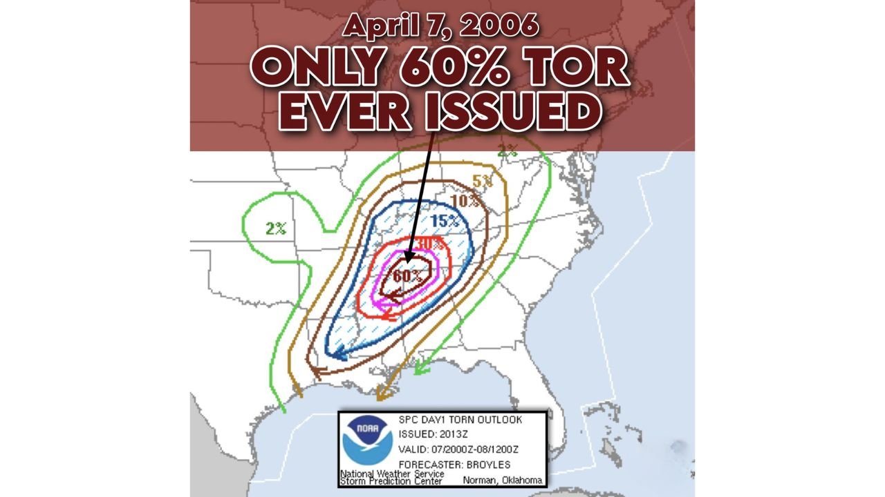
The Storm Prediction Center typically reserves its highest alert — a Level 5 High Risk — for the most dangerous setups, usually tied to a 30% probability of tornadoes within a given area.
However, on April 7, 2006, forecasters took an extraordinary step:
- A 60% tornado probability zone was issued
- This remains the only time in recorded history such a high probability has been used
- The outlook indicated an extreme likelihood of multiple significant tornadoes
To put it into perspective, this meant an unusually high chance of dangerous, long-track tornadoes developing within a relatively short distance of communities across the region.
Outbreak Spanned Multiple States
The event was part of a larger three-day severe weather outbreak from April 6–8, impacting a wide portion of the central and southeastern United States.
Key areas included:
- Mississippi
- Alabama
- Tennessee
- Surrounding parts of the Deep South and Mid-South
In total:
- 73 tornadoes were confirmed across 13 states
- The most intense activity was concentrated across northern Mississippi and Alabama into Tennessee
Atmospheric Setup Fueled a Historic Event
The environment that day was primed for severe weather in nearly every way:
- A strong low-pressure system moving into the region
- A powerful mid-level jet stream enhancing wind shear
- Rich Gulf moisture surging northward, creating instability
- A frontal boundary acting as a trigger for storm development
This combination created ideal conditions for rapid supercell formation, many of which became long-lived and capable of producing tornadoes.
Forecasters Warned of Long-Lived Tornadic Supercells
The official outlook issued that afternoon highlighted just how serious the situation was. It pointed to:
- Rapid supercell development ahead of the jet stream
- Wind profiles becoming highly favorable for rotating storms
- The likelihood of multiple strong tornadoes developing and tracking long distances
These warnings emphasized that violent tornadoes were increasingly likely as storms evolved, particularly across the core risk zone.
How the Event Unfolded
As the system intensified:
- Numerous supercells developed across Mississippi, Alabama, and Tennessee
- Several tornadoes tracked across populated areas
- Many of the tornadoes were weaker (EF0–EF1 range), but
- A few stronger tornadoes, including EF3-level storms, caused more significant damage
Interestingly, some of the strongest tornadoes tracked farther north, including areas near and north of Nashville, Tennessee.
Why This Event Still Matters Today
Despite advances in forecasting, the April 7, 2006 event still stands out because:
- No 60% tornado probability has been issued since
- It represents the upper limit of confidence forecasters have ever expressed
- It serves as a benchmark for identifying truly extreme severe weather setups
Modern forecasts still rely on similar ingredients — instability, wind shear, and moisture — but events reaching this level of certainty remain exceptionally rare.
A Reminder of How Serious Severe Weather Can Be
This historic outbreak highlights how quickly conditions can escalate when the atmosphere aligns perfectly. Even with strong warnings in place, severe weather of this magnitude can still pose widespread risks.
Cabarrus Weekly Perspective
Cabarrus Weekly continues to track both current and historical severe weather patterns to help readers better understand how rare setups like April 7, 2006 develop and why they matter today.
As new storm systems emerge each season, events like this serve as a powerful reminder that some weather setups go beyond the ordinary — and demand heightened awareness and preparation.