April Is Already Running Hot in Maryland, and Next Week’s Heat Surge Will Push Baltimore Even Further Above Normal Before a Cooldown Returns
BALTIMORE, MARYLAND — Spring 2026 is not playing by the rules in Maryland. Temperatures across the state have been swinging wildly — from chilly stretches that felt more like February than April to stretches of warmth that have pushed the monthly average a full 5 degrees above normal. And the pattern is about to tilt even hotter.
Despite the cold that gripped the Baltimore region during parts of this week, the overall thermal ledger for April remains firmly in surplus. That surplus is about to grow.
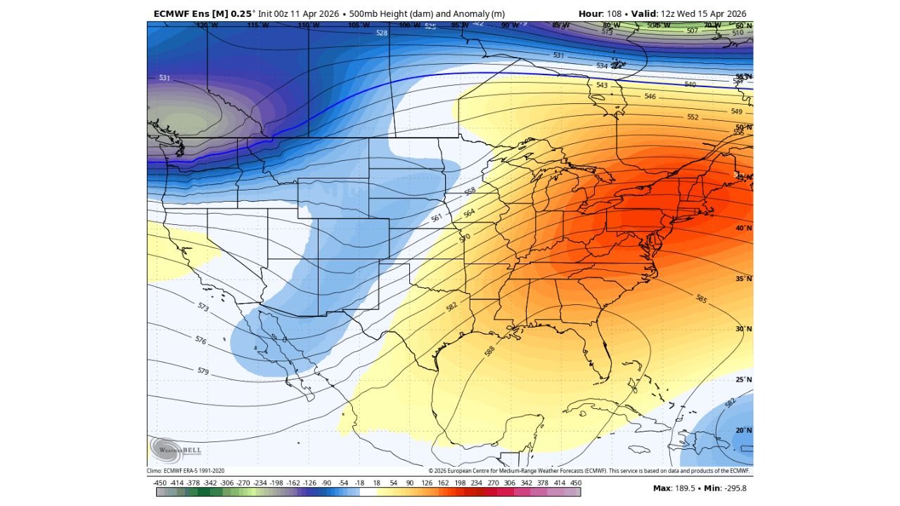
A powerful upper-level ridge — clearly visible in the latest European ensemble model data valid for Wednesday, April 15 — is anchored across the entire Eastern United States. That ridge means one thing: heat is building, and it is arriving fast.
The Ridge Taking Control
The ECMWF ensemble 500mb height anomaly map tells a clear story. Deep orange and red anomaly colors dominate the Mid-Atlantic, the Southeast, and the Ohio Valley through mid-week. These are not borderline anomalies — the signal is strong, placing the atmosphere in a configuration that actively suppresses storm systems and allows surface temperatures to soar.
For Maryland, that translates directly into well-above-normal temperatures beginning as early as Monday, April 14, with the peak warmth arriving Tuesday through Wednesday.
Meanwhile, a contrasting trough is locked in across the Western United States, keeping that region cooler and stormier. The two-pattern setup — western trough, eastern ridge — is a classic spring amplified wave pattern, and it is fully in place.
What Next Week Looks Like for Baltimore and Maryland
The incoming heat surge is not subtle. Baltimore, which has already seen its April average climb 5 degrees above the 1991–2020 climatological baseline, is expected to record temperatures that push well into the upper 70s and potentially touch the low-to-mid 80s by mid-week.
Cities across central and western Maryland — including Frederick, Hagerstown, and Cumberland — may see even warmer readings given their inland positions and reduced maritime influence from the Chesapeake.
The Washington, D.C., suburbs extending into Prince George’s and Montgomery counties will also feel the full force of this ridge, with urban heat island effects amplifying what is already going to be a notable warm stretch.
The Cooldown Signal After April 18–19
Here is the other side of this story: the pattern does not hold indefinitely. Model data is showing signs of a pattern change after the weekend of April 18–19, with cooler air making a return push into the Mid-Atlantic.
This fits the broader theme of Spring 2026 in Maryland — big swings, no sustained stretch in either direction. Warm, then cold, then warm again. Residents who enjoyed the brief warm-up earlier in the season only to be blindsided by a late chill will recognize this cycle.
The timing and depth of the post-April 19 cooldown carries uncertainty, but the signal is consistent enough across models to take seriously.
City-Specific Temperature Outlook: April 14–16 Heat Surge
| City | Expected High Range | Departure from Normal |
|---|---|---|
| Baltimore | 78–83°F | +8 to +13°F |
| Annapolis | 76–81°F | +7 to +12°F |
| Frederick | 80–85°F | +9 to +14°F |
| Hagerstown | 79–84°F | +9 to +13°F |
| Cumberland | 78–83°F | +8 to +12°F |
| Salisbury | 74–79°F | +6 to +11°F |
Ranges based on ECMWF ensemble guidance valid April 14–16, 2026. Exact values subject to change.
Precipitation Outlook Through April 19
| City | Rain Chance (Apr 14–19) | Notable Timing |
|---|---|---|
| Baltimore | Low — 15–20% | Isolated, near pattern change |
| Frederick | Low — 10–15% | Mainly dry under ridge |
| Hagerstown | Low — 10–15% | Mainly dry |
| Annapolis | Low — 15–20% | Slight chance late week |
| Salisbury | Low — 20–25% | Coastal moisture possible |
What to Wear and How to Prepare
The jump from this week’s chill to next week’s heat will be sharp. Here is how to stay ahead of it:
- Monday through Wednesday: Light layers in the morning — temperatures may still start in the mid-50s — but afternoons will feel summer-like. T-shirts, shorts, and sun protection are appropriate by midday.
- Stay hydrated. Early-season heat events are particularly impactful because the body has not yet acclimated to warm temperatures after months of cooler weather.
- Check on elderly neighbors and young children — they are most vulnerable during abrupt early-season heat surges.
- After April 19: Have a light jacket or mid-layer ready. The cooldown could be notable depending on how the pattern shift evolves.
Forecast Confidence Level
High — for the heat surge through April 15–16. The ECMWF ensemble shows strong agreement on the ridge position and intensity. The warm signal is well-established.
Medium — for the post-April 19 cooldown. The signal exists across multiple models, but the exact timing, depth, and duration of the cooler air return carries meaningful spread. Monitor updates through the week.
Cabarrus Weekly Perspective
What is happening in Maryland this April is a textbook example of amplified spring atmospheric patterns — and it matters beyond just the week’s forecast. The 5-degree-above-normal monthly anomaly already recorded reflects a broader trend where spring months are seeing larger temperature excursions from baseline in both directions.
The ridge dominating the East through mid-week is not just a Maryland story. The same feature is driving above-normal heat from the Carolinas to New England. But for Maryland specifically, the combination of the monthly surplus already in the books and the incoming mid-week peak means April 2026 could rank among the warmer Aprils on record depending on how the final two weeks of the month play out.
The cooldown signal after April 18–19 is worth watching not just for comfort reasons, but because late-April pattern changes in amplified spring years can sometimes introduce sharp contrasts — including the possibility of frost risk in parts of western Maryland if the cold air is deep enough. That outcome remains uncertain but is not off the table.
The Bottom Line
Maryland’s Spring 2026 is defined by extremes, and next week delivers the latest chapter. A strong upper-level ridge will send temperatures 8 to 14 degrees above normal across the state from roughly April 14–16, with Baltimore targeting highs in the upper 70s to low 80s. April is already running 5 degrees warmer than average, and this surge will widen that gap further. A cooldown is signaled after the weekend of April 18–19, but its strength remains uncertain. Expect continued temperature volatility through the rest of the month.
Stay ahead of Maryland’s swinging spring temperatures before the next shift catches you off guard. Visit cabarrusweekly.com for daily severe weather coverage, storm alerts, and forecast updates from across the United States — because knowing early is the difference that matters.