Arctic Air Outbreak to Grip Midwest, Great Lakes, Appalachians, Southeast, and Florida With Dangerous Cold From January 29 to February 4
UNITED STATES — After the major winter storm currently impacting large parts of the country, an expansive and unusually intense Arctic air mass is expected to surge southward, bringing dangerously cold temperatures to much of the central, eastern, and southeastern United States, including Indiana, Illinois, Ohio, Michigan, Kentucky, Tennessee, North Carolina, South Carolina, Georgia, and even Florida.
Why This Cold Outbreak Is Concerning
Forecast guidance shows frigid Arctic air spreading deep into the Lower 48, with some regions experiencing temperatures 30 to 40 degrees below normal. This is not a brief cold snap — the signal supports several consecutive days of hazardous cold, especially across the Midwest, Great Lakes, and interior Southeast.
This cold will arrive immediately after a high-impact winter storm, raising additional concerns about power restoration, icy infrastructure, and prolonged travel issues.
High-Risk Cold Zones: Midwest and Great Lakes
The highest risk for dangerous cold is expected across Indiana, Illinois, Ohio, Michigan, Wisconsin, and surrounding states, where subfreezing temperatures will be locked in for days.
In these areas, wind chills may drop to dangerous levels, increasing the risk of frostbite and hypothermia, particularly for anyone without adequate heating.
Moderate to Significant Cold Expands Into the Southeast
The cold air mass will not stop in the Midwest. Forecasts indicate moderate to high cold risk expanding into Kentucky, Tennessee, the Carolinas, Georgia, and Alabama, with temperatures falling well below seasonal averages.
While snow and ice may not be the primary threat in the Deep South during this phase, hard freezes and prolonged cold could impact pipes, pets, livestock, and sensitive infrastructure.
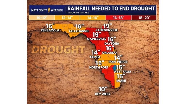
Florida Not Immune to This Pattern
Even Florida is expected to feel the effects of this Arctic surge. After a short-lived warm-up, cooler and potentially chilly conditions are expected to return late next week, especially across north and central Florida.
While this is not expected to be a historic freeze for Florida, the contrast from recent warmth will be notable, and colder-than-normal mornings are likely.
Timing: January 29 Through February 4
Based on current data:
- High-risk cold: January 29 through February 1 across the Midwest and Great Lakes
- Moderate risk cold: January 29 through February 2 expanding south and east
- Lingering chill: Through February 4 for parts of the Southeast and East Coast
This suggests a long-duration cold event, not a quick in-and-out system.
Added Risk Following the Ice Storm
One of the most critical factors is timing. If ice-related power outages occur during the preceding winter storm, restoration efforts could be severely challenged by the incoming Arctic cold, especially in areas unaccustomed to prolonged freezes.
Bottom Line
A dangerous Arctic air outbreak is increasingly likely to follow the current winter storm, impacting a large portion of the United States from the Midwest to the Southeast and Florida. The combination of extreme cold, recent ice and snow, and potential power disruptions makes this a situation that warrants close monitoring and early preparation.
Residents should prepare for extended cold, protect pipes, ensure backup heating options, and check on vulnerable individuals and pets as this pattern unfolds. For continued updates and state-by-state impact breakdowns, follow CabarrusWeekly.com.