Arctic “Climate Shock” Could Shatter Cold Records in Greenland as Models Hint at -88°F — What It Means for the Northern Hemisphere and Beyond
GREENLAND — Weather models are signaling an extraordinary and potentially historic cold outbreak over Greenland this week, with forecast temperatures plunging as low as -88.5°F, approaching one of the coldest readings ever observed in the Northern Hemisphere.
Meteorologists describe the setup as a possible “all-time record cold” scenario, driven by what some are calling an unprecedented Arctic “climate shock.” While the most extreme cold is focused over Greenland and the high Arctic, the broader atmospheric ripple effects could influence weather patterns across North America and Europe — including the southeastern United States.
Model Data Shows Extreme Core of Cold Centered Over Greenland
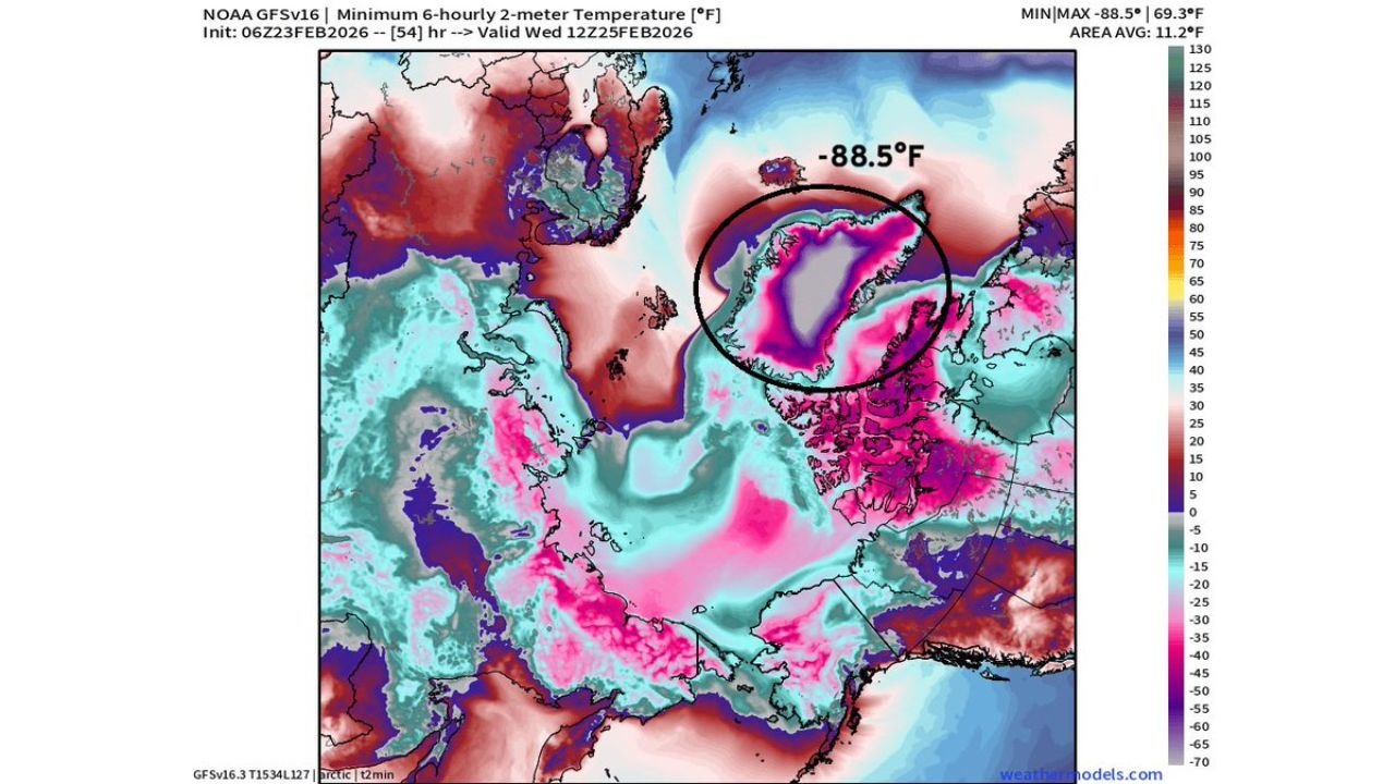
Forecast guidance from NOAA’s GFS model shows minimum 6-hour temperatures over central and northern Greenland dropping to -88.5°F, highlighted in deep pink and purple shading across the ice sheet.
To put that in perspective:
- The record low temperature for the Northern Hemisphere is -93.3°F, recorded in Greenland on December 21, 1991.
- That historic cold followed the Mount Pinatubo eruption, which altered atmospheric circulation patterns.
- The current forecast would fall just a few degrees shy of that benchmark.
Temperature anomaly maps show Greenland engulfed in intense negative departures from average, meaning this isn’t just seasonal cold — it’s dramatically below normal even by Arctic standards.
A “Climate Shock” in the Arctic
The anomaly maps illustrate a striking contrast across the Northern Hemisphere. While Greenland experiences extreme cold anomalies, parts of the Arctic Ocean and other regions show pockets of above-normal temperatures.
This sharp temperature gradient can destabilize the polar vortex and alter jet stream flow. When the Arctic experiences intense cold pooling in one region, it can displace milder air elsewhere and influence storm tracks across mid-latitudes.
In past winters, similar Arctic configurations have contributed to:
- Stronger coastal storms
- Sudden temperature swings
- Increased risk of cold air intrusions into the continental United States
Why Cabarrus County Should Pay Attention
While Cabarrus County, North Carolina is thousands of miles from Greenland, major Arctic shifts can sometimes ripple southward days or weeks later.
Extreme Arctic cold consolidations often:
- Reinforce high-latitude blocking patterns
- Shift the jet stream
- Open pathways for colder-than-normal air into the eastern U.S.
Earlier this season, temperature whiplash has already been observed across parts of the Southeast, with sharp swings between mild and frigid conditions. If Arctic pressure patterns amplify further, it could support more pronounced cold snaps later in the pattern cycle.
At this time, there is no immediate Arctic outbreak forecast specifically for Cabarrus County, but meteorologists will be watching downstream effects closely.
Could Records Actually Fall?
Forecasts beyond several days always carry uncertainty, especially in extreme environments like central Greenland. However, models consistently projecting sub -85°F temperatures raise the possibility that at least localized record-challenging cold could occur.
To break the all-time Northern Hemisphere record, temperatures would need to drop below -93.3°F. That is rare and requires near-perfect radiational cooling conditions over the ice sheet.
Even if the record is not broken, temperatures in the -80s represent extraordinary Arctic severity.
The Bigger Picture: Arctic Extremes and Global Impacts
The Arctic plays a crucial role in global atmospheric balance. When extreme cold intensifies in one sector of the polar region, it can shift pressure systems and alter wind patterns across continents.
Such disruptions can:
- Strengthen nor’easters along the East Coast
- Enhance winter storm development
- Cause sudden seasonal reversals in the Southeast
Whether this Greenland cold wave directly influences North Carolina weather remains to be seen. But large-scale Arctic anomalies rarely stay isolated without some downstream effect.
Meteorologists will continue monitoring model trends over the coming days for any indications of pattern changes that could affect the Carolinas.
As always, Cabarrus Weekly will provide updates if Arctic shifts begin influencing local conditions.
Stay with CabarrusWeekly.com for continuing weather coverage and local forecast updates as this rare Arctic event unfolds.