Arkansas Faces High-Impact Winter Storm as Ice and Heavy Snow Threaten Travel From Friday Through Monday
Arkansas — A major winter storm is expected to impact much of Arkansas beginning Friday afternoon, with dangerous conditions likely to intensify Friday night and persist through the weekend. Forecast data shows a high risk of ice accumulation, overlapping with periods of snow, creating the potential for widespread travel disruptions and power outages across large portions of the state.
Meteorologists warn that once frozen precipitation begins, conditions could deteriorate rapidly, particularly across central and northern Arkansas.
Storm Timing: When Conditions Begin to Deteriorate
According to arrival-time projections, precipitation will move into Arkansas in phases on Friday:
- Western Arkansas: Frozen precipitation may begin before 3 p.m. Friday
- Central Arkansas: Impacts likely develop between 3 p.m. and 7 p.m. Friday
- Eastern Arkansas: Precipitation arrives after 7 p.m. Friday
Once freezing rain or sleet begins, road conditions are expected to worsen quickly as surface temperatures fall below freezing Friday evening.
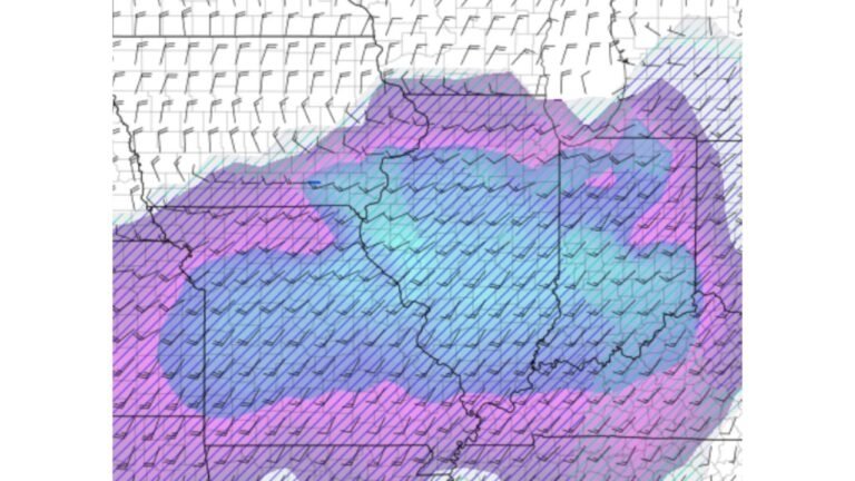
Ice Is the Primary Concern Across Arkansas
Forecast guidance strongly suggests that ice accumulation — not snow — will be the dominant threat for much of Arkansas.
Moderate icing is projected across a wide corridor stretching from central Arkansas into the eastern half of the state. Ice accumulation at this level can:
- Make roads extremely slick and dangerous
- Lead to tree damage and scattered power outages
- Cause extended travel delays lasting into Sunday
Forecasters caution that even small increases in ice thickness can dramatically increase impacts, especially overnight when temperatures remain below freezing.
Snowfall Amounts Still Significant in Northern Zones
While ice remains the dominant concern, snow will also play a role, particularly across northern Arkansas.
Current projections show:
- 4–8 inches of snow possible in northern sections
- 8–12 inches in localized bands just north of Arkansas
- Higher totals remain possible if colder air deepens faster than expected
Snow totals may decrease farther south as precipitation transitions to sleet or freezing rain.
Travel Conditions Likely to Be Hazardous for Several Days
Travel disruptions are expected to become widespread once precipitation begins Friday and could persist through Sunday or Monday, depending on ice accumulation and cleanup efforts.
Officials warn drivers to prepare for:
- Ice-covered highways and bridges
- Reduced visibility during periods of sleet and snow
- Dangerous driving conditions along major corridors, including routes near Interstate 20 to the south
Even areas that avoid heavy snow could still experience severe icing, which often causes more long-lasting impacts.
Forecast Uncertainty Remains, But Risk Is High
While some forecast models suggest extreme snow totals across parts of the southern Plains, meteorologists stress that official warnings are more conservative, calling for lower but still impactful amounts.
However, forecasters emphasize that:
- Model consistency has increased
- Impacts are now within 36 hours
- Residents should treat higher-end outcomes as plausible, even if not the most likely scenario
This is especially true for ice, where small changes in temperature can dramatically alter impacts.
What Residents Should Do Now
With impacts approaching quickly, residents across Arkansas are urged to:
- Finalize travel plans before Friday afternoon
- Prepare for potential power outages
- Monitor forecast updates closely as storm details are refined
- Avoid unnecessary travel once freezing precipitation begins
Officials stress that once ice forms, road conditions may remain dangerous even after precipitation ends.
Bottom Line
Arkansas is facing a high-impact winter storm with the greatest risk coming from significant ice accumulation, compounded by periods of snow. Conditions are expected to worsen quickly Friday evening, with hazardous travel and infrastructure disruptions possible through the weekend.
Residents should prepare now and stay alert for updated warnings as the storm approaches.