Arkansas, Texas and Oklahoma Face Increasing Severe Storm Threat Early Next Week With Tuesday Risk Expanding Statewide
ARKANSAS — Severe weather chances are beginning to ramp up across parts of the southern United States, with Arkansas emerging as a key focus area for early next week, especially as conditions intensify from Monday into Tuesday.
Monday Brings Limited Risk to Western Arkansas
The early phase of this developing pattern will begin on Monday, but impacts appear relatively limited at first.
- Risk area remains small and focused on far western and northwestern Arkansas
- Storm coverage is expected to be more isolated
- Any severe weather that develops could still produce strong winds or hail, but overall coverage should be lower
This initial setup suggests a building pattern rather than a full outbreak day, with the atmosphere gradually becoming more favorable.
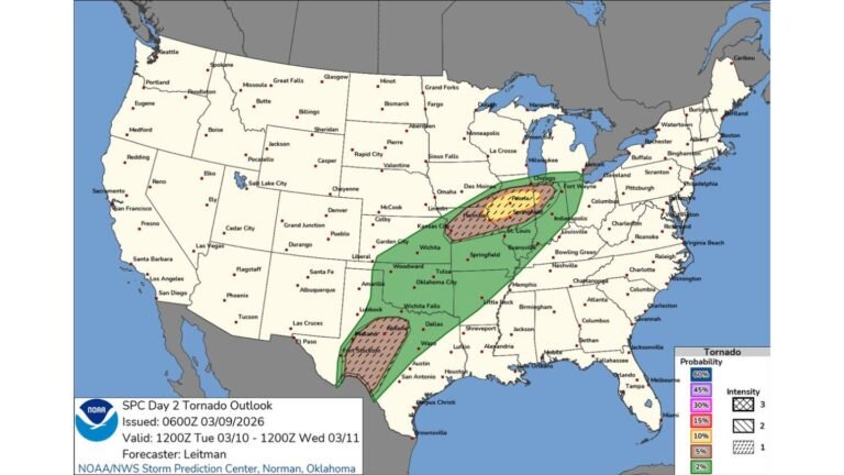
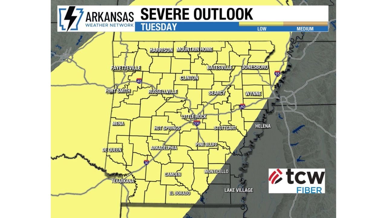
Tuesday Expands Threat Across Nearly the Entire State
By Tuesday, the situation changes significantly.
- Severe weather risk expands to cover most of Arkansas
- Cities including Little Rock, Fayetteville, Fort Smith, Jonesboro, Pine Bluff, and Hot Springs fall within the highlighted zone
- The setup becomes more supportive of widespread thunderstorm development
This marks a transition from a localized event to a statewide severe weather concern.
All Severe Weather Hazards on the Table
Forecast signals indicate that multiple types of severe weather hazards could occur, including:
- Tornadoes, potentially developing within stronger storms
- Damaging straight-line winds, capable of causing power outages and tree damage
- Large hail, especially in more intense storm cores
The expanding coverage and favorable conditions suggest that Tuesday could become the more impactful day of the two.
Why the Pattern Is Becoming More Active
The increase in severe weather potential is tied to a developing atmospheric setup:
- Increasing moisture returning from the Gulf of Mexico
- Strengthening wind fields and instability
- A system moving into the region providing lift for storm development
Together, these ingredients are creating an environment where storms can organize more efficiently and become severe.
A Busy Weather Pattern Ahead
Looking beyond Tuesday, the broader pattern suggests that active weather may continue into next week, rather than being limited to a single day.
- Repeated storm chances may occur
- Conditions could remain favorable for additional severe weather episodes
- The overall setup points to a prolonged active period rather than a quick event
Cabarrus Weekly Perspective
This developing situation across Arkansas highlights how quickly spring weather can shift from quiet to active. While Monday offers only a limited threat, Tuesday’s expanding risk across nearly the entire state signals a more serious concern.
Residents across Arkansas — and nearby areas in Texas, Oklahoma, and surrounding regions — should use the quieter period now to stay alert and prepared as severe weather chances increase heading into next week.