Back-to-Back Pacific Storms to Slam California and the Pacific Northwest, Bringing Heavy Mountain Snow to Colorado While Dry Air Dominates the Plains
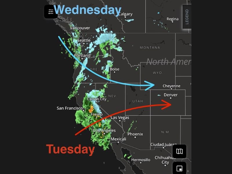
WESTERN UNITED STATES — Two powerful Pacific storm systems are set to impact the West Coast Tuesday and Wednesday, delivering rounds of heavy rain to California and the Pacific Northwest while funneling significant snowfall into the Colorado Rockies.
As these storms track inland, much of the central United States will remain on the drier side of the system, with notably low humidity east of the Continental Divide.
First Storm Targets California on Tuesday
The initial system moves into California on Tuesday, spreading widespread rainfall from San Francisco south through Fresno and Los Angeles. Radar projections show a concentrated band of heavier rain pushing inland, particularly across central and southern parts of the state.
Higher elevations of the Sierra Nevada are expected to receive accumulating snow, while valley locations contend with steady rainfall and locally heavier downpours. Moisture from this system then advances inland toward Nevada and Utah, gradually weakening as it moves east.
Second System Impacts the Pacific Northwest Wednesday
By Wednesday, another storm pushes into the Pacific Northwest, affecting Seattle, Portland, and Vancouver with additional rain and mountain snow.
Snowfall will expand across higher terrain in the Cascades and northern Rockies as colder air wraps into the system. This second surge of moisture reinforces unsettled conditions across Washington and Oregon midweek. The trajectory of the storm system curves southeastward, helping direct energy and moisture toward the central Rockies.
Heavy Snow for the Colorado Mountains
As Pacific energy crosses the interior West, it will enhance snowfall in the Colorado mountains, especially Tuesday into Wednesday.
Higher elevations west of Denver and near the Continental Divide are positioned for the heaviest accumulations as moist air is forced upslope into the Rockies. Travel through mountain passes could become hazardous at times due to accumulating snow and reduced visibility.
Dry and Low Humidity East of the Divide
While the West Coast and Rockies deal with active weather, areas east of the Continental Divide — including parts of Wyoming, eastern Colorado, and the central Plains — remain largely dry.
Humidity levels are expected to stay notably low, creating elevated fire-weather concerns in some locations. The contrast between heavy coastal precipitation and dry interior air will be pronounced through midweek.
Scattered Showers Possible Late Week
The best chance for scattered showers east of the Rockies appears to arrive Wednesday night through Friday night, though coverage looks limited compared to the heavier precipitation in the West. Most locations across the Plains and Midwest are expected to remain on the quieter side of this pattern until later in the week.
Residents in California, the Pacific Northwest, and the Colorado mountains should prepare for periods of heavy precipitation and difficult travel conditions through Wednesday. If you’re experiencing changing conditions in your area, share your local weather updates with CabarrusWeekly.com so others can stay informed as these Pacific systems move inland.

