Backdoor Cold Front Could Split Maryland and Virginia Midweek, Holding Baltimore in the 40s While Southern Virginia Pushes Toward 60s
VIRGINIA — A sharp temperature divide could set up across the Mid-Atlantic by midweek as a backdoor cold front attempts to push southwest and stall somewhere near Maryland and northern Virginia, placing Baltimore directly on the battleground between chilly air and early-spring warmth.
Forecast guidance shows a dramatic north-to-south contrast developing by Wednesday afternoon.
Backdoor Cold Front Creates a Mid-Atlantic Temperature Fence
Unlike traditional cold fronts that sweep west to east, a backdoor front slides in from the northeast, often off the Atlantic. This setup brings cool maritime air southward into Maryland and northern Virginia, undercutting warmer air trying to surge north from the Carolinas.
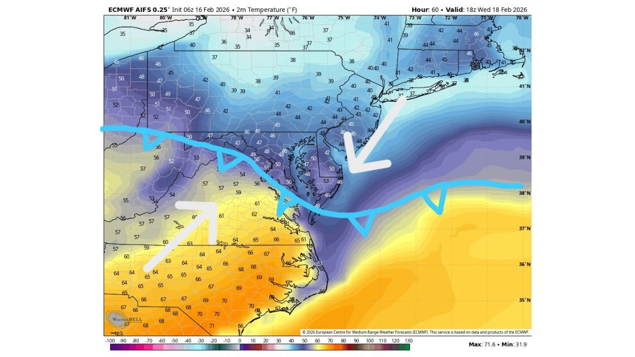
Model data valid Wednesday evening shows 40s north of the boundary, including much of central and northern Maryland. Meanwhile, areas south of the front — especially across southern Virginia — could climb into the lower to middle 60s.
Baltimore appears to sit nearly on this dividing line, meaning small shifts in the front’s position could drastically alter afternoon temperatures.
Baltimore: Stuck in the 40s or Briefly Near 60?
Current projections suggest much of Maryland, including Baltimore, could remain in the mid to upper 40s if the cooler air wins out. Temperatures around 44 to 48 degrees are indicated north and east of the stalled boundary.
Just 75 to 100 miles south, readings could be dramatically warmer. Central and southern Virginia show widespread 60 to 66 degrees, with even some upper 60s appearing farther south toward North Carolina.
This kind of gradient means Baltimore’s final temperature forecast remains highly sensitive to the exact placement of the boundary. A slight northward shift would allow milder air to surge in. A slight southward push would keep conditions firmly chilly.
Why Backdoor Fronts Are Tricky
Backdoor cold fronts are notoriously difficult to forecast because they are influenced heavily by coastal pressure patterns and low-level wind direction. A persistent northeast wind can lock in cool air, especially near the Chesapeake Bay and I-95 corridor.
If onshore flow strengthens, Baltimore and surrounding areas could stay socked in with cooler air all day, despite warmer air pushing north just to the south and west.
Conversely, if southwest winds briefly gain control, temperatures could jump quickly before cooler air filters back in.
A Classic Mid-Atlantic Battleground
The midweek pattern is shaping up to be a classic Mid-Atlantic standoff. Northern Maryland and parts of Pennsylvania remain solidly in the 40s, while southern Virginia and North Carolina experience a noticeable warm-up.
Model guidance shows a clear thermal contrast stretching from west to east across the region, reinforcing the idea that communities on opposite sides of the boundary could experience completely different conditions.
For Maryland residents, especially in and around Baltimore, the key question is which side of the “fence” the city ultimately falls on.
Another update is expected as newer data refines the position of the boundary.
If you notice temperatures fluctuating dramatically across short distances midweek, let us know what you’re seeing in your neighborhood. Share your conditions and observations with CabarrusWeekly.com as this temperature split unfolds.