Backdoor Cold Front Locks Pennsylvania in 40s While Ohio and West Virginia See 50s and 60s Late Week as Canadian High Pressure Pushes Chilly Atlantic Air South
PENNSYLVANIA — A classic backdoor cold front is setting up across the Northeast late this week, keeping much of Pennsylvania locked in chilly 40-degree highs Friday and Saturday while noticeably warmer air builds just to the west across Ohio and parts of West Virginia.
This pattern is being driven by high pressure centered in southeastern Canada, which circulates air clockwise and pushes cool Atlantic air southwestward into the Mid-Atlantic and Pennsylvania.
Why It’s Called a Backdoor Cold Front
Unlike traditional cold fronts that move west to east, a backdoor cold front slides in from the northeast — essentially coming in “through the back door.” In this case:
- High pressure over southeastern Canada
- Clockwise wind flow
- Cool marine air spilling inland
The result is a sharp temperature gradient across state lines.
Pennsylvania: Highs Stuck in the 40s
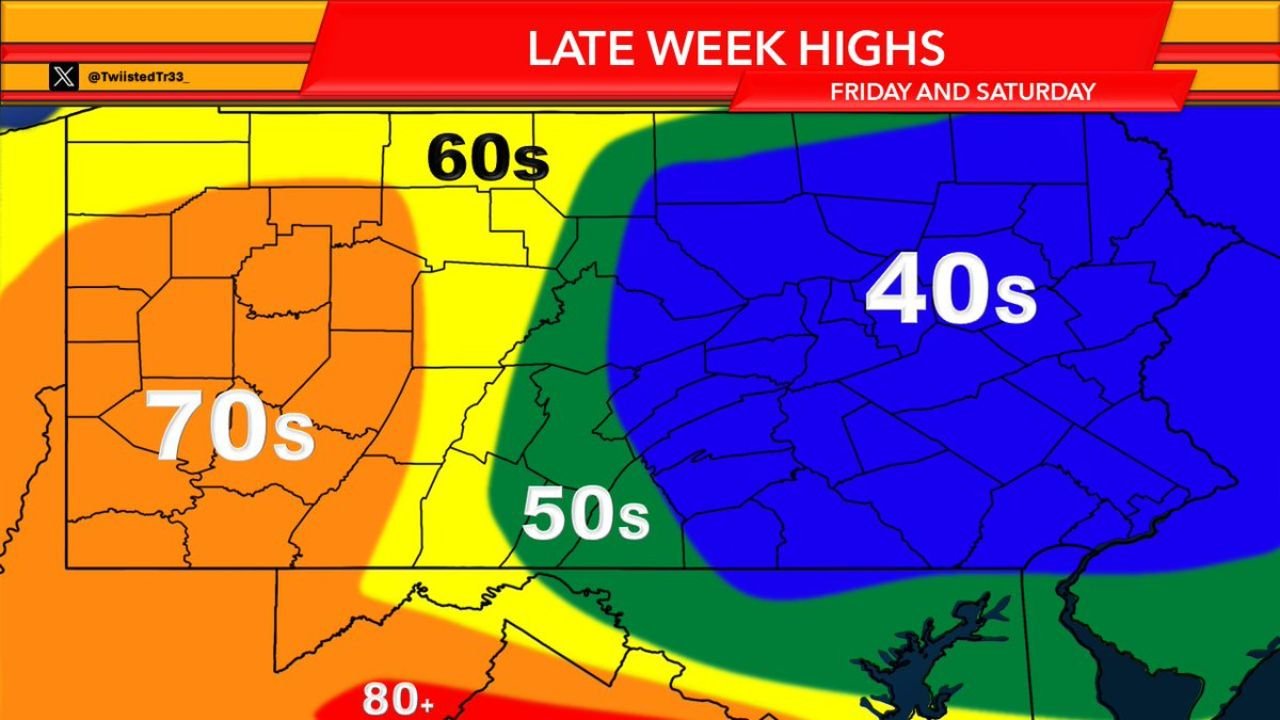
The temperature outlook for Friday and Saturday shows much of:
- Central Pennsylvania
- Eastern Pennsylvania
- Western Pennsylvania
Remaining in the 40s for afternoon highs.
This cooler air mass will likely bring:
- Persistent cloud cover
- Areas of fog
- Periods of drizzle
The chilly air is expected to hold firm through at least Saturday, delaying any meaningful warm-up until Sunday or later.
Warmer Just to the West
Meanwhile, conditions shift dramatically just west of Pennsylvania:
- Eastern Ohio may reach the 50s
- Parts of western Ohio and Indiana climb into the 60s
- Farther southwest into the central U.S., some locations surge into the 70s
This sharp divide highlights how backdoor fronts can create major contrasts over short distances.
What to Expect Late Week
Friday and Saturday will likely feel more like early spring than late spring across Pennsylvania, with damp and gray conditions dominating.
Temperatures by region:
- Pennsylvania: 40s
- Eastern Ohio and parts of West Virginia: 50s
- Farther west: 60s and even 70s
The presence of cool Atlantic air will suppress daytime heating, especially east of the Appalachian Mountains.
When Does It Warm Up?
Current trends suggest the warm-up may not begin for most of Pennsylvania until at least Sunday, once the Canadian high weakens or shifts and winds become less favorable for cold air drainage from the northeast.
Until then, expect a classic backdoor cold front pattern: chilly, cloudy, and stubborn.
CabarrusWeekly.com will continue tracking major national weather patterns and provide updates as the late-week setup evolves.