Baltimore and I-95 Corridor Brace for Late-Sunday Snow Chance as Canadian Model Leads Forecast, Rain Likely to Follow Sunday Night
MARYLAND — A developing weekend system could bring a brief window of snow late Sunday, especially north and west of the I-95 corridor, before transitioning to rain Sunday night as temperatures remain marginally above freezing.
Forecast confidence is leaning toward the Canadian model solution, which has shown the most consistency with this storm setup.
Canadian Model Signals Late-Day Snow North and West of I-95
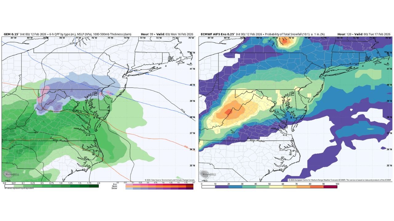
Latest Canadian (GEM) guidance shows precipitation spreading into the region Sunday afternoon and evening, with a band of snow developing across central and western Maryland, including areas west of Baltimore.
The heaviest snow signal appears across northern Maryland into southern Pennsylvania, where colder air is more established. Farther south toward Washington, D.C., and southern Maryland, precipitation trends more toward rain.
Surface temperatures are expected to hover near or slightly above freezing, limiting the potential for significant accumulation in lower elevations and urban corridors.
Baltimore Metro: About a 50% Chance of 1 Inch or More
European ensemble guidance (ECMWF AIFS Ensembles) indicates roughly a 50 percent probability of at least 1 inch of snowfall across parts of the Baltimore metro area.
Probabilities increase farther north and west of the city, while areas closer to the Chesapeake Bay show lower confidence for measurable accumulation due to warmer boundary-layer temperatures.
This suggests Baltimore sits near a critical transition zone where small shifts in storm track or temperature profiles could determine whether totals remain light or briefly reach advisory-level amounts.
Mix to Rain Sunday Night as Warmer Air Wins
As the system matures Sunday night, forecast soundings show warmer air intruding aloft and at the surface, leading to a changeover from snow to rain for much of central Maryland.
Even where snow falls late Sunday, accumulations are expected to be modest given the marginal temperatures and eventual mixing. Road impacts may be limited mainly to grassy or elevated surfaces unless colder air holds longer than currently projected.
I-95 Corridor: Sharp Gradient Expected
The I-95 corridor, including Baltimore and areas toward Philadelphia, appears positioned along a tight precipitation gradient.
Communities north and west of I-95 have the best chance to see measurable snowfall before the changeover. Areas south and east of the corridor may see mostly rain with only brief mixing at onset.
Such setups often produce highly localized differences, where totals can vary significantly over short distances.
Bottom Line
Late Sunday could bring a brief period of snow to northern and western Maryland, including parts of the Baltimore metro area, before warmer air forces a transition to rain Sunday night. The Canadian model has shown the most consistent handling of this storm, and ensemble guidance supports at least a moderate chance for light accumulation north and west of I-95.
Forecast details will continue to refine as the system approaches. Residents across Maryland should monitor updates, especially if traveling Sunday evening.
If you observe snow or changing conditions in your neighborhood, share your reports with us at CabarrusWeekly.com.