Baltimore and Maryland Face Strong Storms Wednesday Evening in the 80s Before Dramatic Temperature Crash Into the 40s and 50s by Thursday Afternoon as Cold Air Surges From the Northeast
BALTIMORE, MARYLAND — The Baltimore metro area and surrounding Maryland communities are heading into one of the most dramatic two-day weather swings of the spring season. Scattered strong thunderstorms are expected to develop Wednesday evening, April 1, 2026, in a warm air mass pushing temperatures into the low to mid 80s — before a powerful surge of cold air from the Northeast sends temperatures crashing into the 40s and 50s by Thursday afternoon, April 2.
The temperature swing from Wednesday’s highs to Thursday afternoon represents a drop of 30 to 40 degrees within 24 hours — one of the most abrupt single-day temperature reversals the Baltimore region has seen this spring.
This forecast is based on the HRRR model initialized March 31, 2026 at 06z and the NAM 3km model initialized March 31, 2026 at 06z, both valid for the Wednesday night through Thursday afternoon period.
Wednesday Evening — Warm, Humid, and Stormy
Wednesday afternoon will feel nothing like the cold air that follows it. Temperatures across the Baltimore metro and central Maryland will climb into the low to mid 80s — some of the warmest readings of the spring so far — fueled by a deep warm air mass that has been building across the Mid-Atlantic ahead of the approaching cold front.
That warmth comes with a cost. Scattered thunderstorms are expected to develop Wednesday evening as daytime heating destabilizes the warm, humid air mass and an approaching frontal boundary provides the lift needed to fire storm development.
This is not expected to be a widespread severe weather event — forecasters are not anticipating a major organized severe weather outbreak across the Baltimore area Wednesday. However, a few of the storms could be strong, capable of producing gusty winds, lightning, and locally heavy rainfall. Residents should remain weather-aware Wednesday evening and have a way to receive storm alerts in real time.
Wednesday Night — Storm Line Moves Through
The HRRR model valid Wednesday night shows an active storm complex moving through the Baltimore, Washington DC, and surrounding Mid-Atlantic corridor. Radar reflectivity values reaching into the upper 50s and low 60s dBZ indicate storm cells capable of producing heavy rainfall rates, frequent lightning, and gusty wind gusts within the stronger cells.
The storm activity is concentrated in a corridor stretching from western Maryland and the DC suburbs eastward through Baltimore and toward the Chesapeake Bay. The storm line is expected to push through during the evening and overnight hours before gradually exiting the region.
Key airports and transportation corridors to watch Wednesday night:
- Baltimore Washington International (BWI) — directly in the storm corridor
- Reagan National (DCA) and Dulles (IAD) — active storm cells forecast nearby
- Interstate 95, I-70, and I-270 corridors — expect reduced visibility and wet roads during storm passage
Thursday Afternoon — The Cold Air Arrives
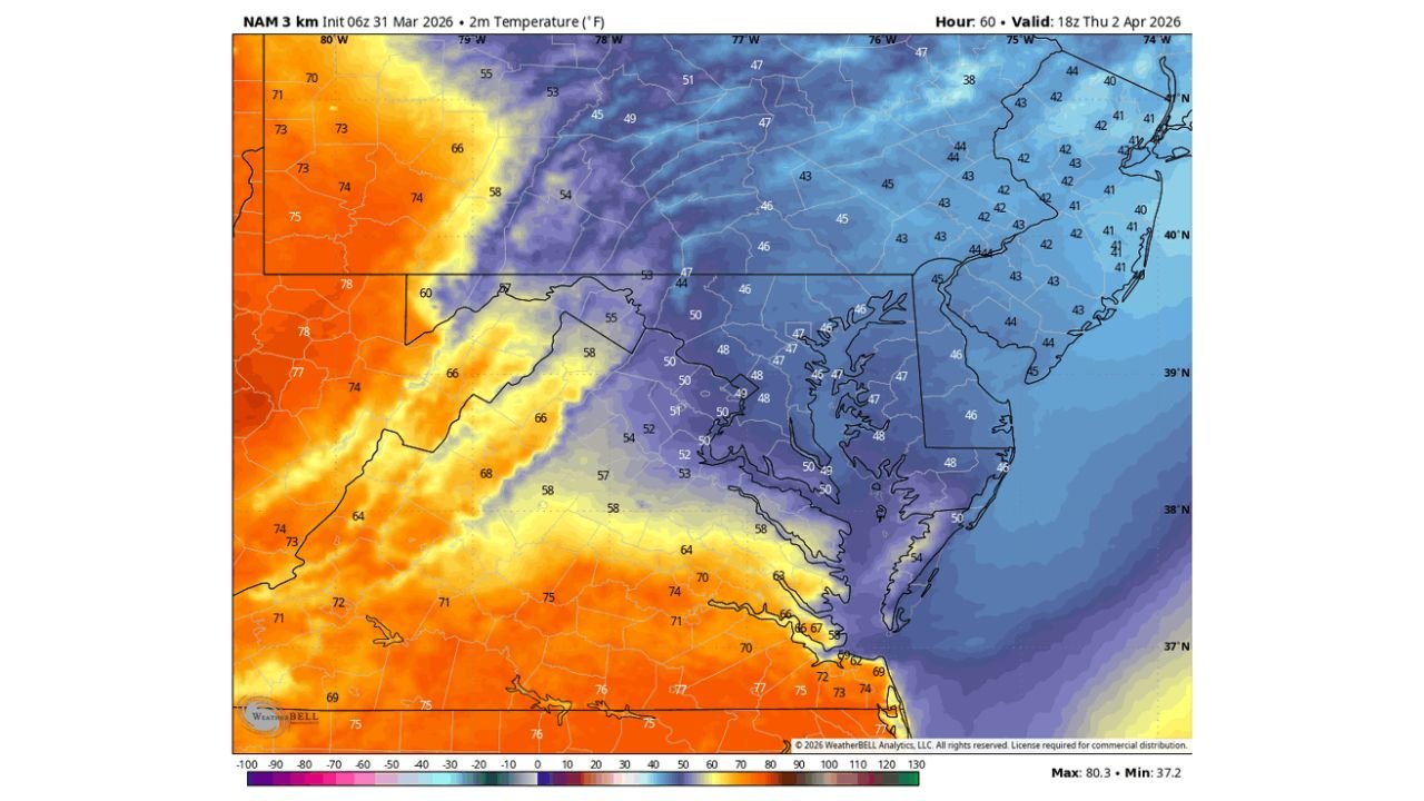
What happens after the storms clears Wednesday night is the more dramatic part of this forecast. The NAM 3km model valid Thursday afternoon, April 2 shows one of the most striking temperature contrast maps seen across the Mid-Atlantic this spring.
Inland Virginia and the western suburbs of Washington DC are still holding onto temperatures in the mid to upper 50s and low 60s Thursday afternoon — warm enough to feel like a mild spring day. But push eastward toward the Chesapeake Bay and the picture changes completely.
Baltimore sits directly on the sharp temperature boundary Thursday afternoon. The NAM places Baltimore metro temperatures in the upper 40s to low 50s — a drop of 30 to 35 degrees from Wednesday’s afternoon highs. The cold air is not spreading from the west in the typical fashion — it is surging southward from the Northeast, creating an unusually sharp and fast-moving cold boundary across the region.
Coastal Delaware, New Jersey, and the Maryland Eastern Shore see the coldest Thursday readings — with temperatures dropping into the low to mid 40s as the Northeast cold air pushes aggressively into the region. Meanwhile, southern Virginia and North Carolina are still sitting in the 70s — illustrating just how sharp and dramatic this temperature gradient is across the Mid-Atlantic Thursday afternoon.
Temperature Comparison — Wednesday vs Thursday
| Location | Wednesday High | Thursday Afternoon | Drop |
|---|---|---|---|
| Baltimore, MD | Low 80s | Upper 40s–Low 50s | 30–35°F |
| Washington DC suburbs | Low to Mid 80s | Mid 50s | 25–30°F |
| Western Maryland | Mid 80s | Upper 50s–Low 60s | 20–25°F |
| Chesapeake Bay coast | Upper 70s | Mid to Upper 40s | 30–35°F |
| Delaware / New Jersey coast | Upper 70s | Low to Mid 40s | 35–40°F |
| Southern Virginia | Mid 80s | Low to Mid 70s | 10–15°F |
Forecast Confidence Level
High confidence on Wednesday evening storm development across the Baltimore metro and central Maryland — the warm air mass and approaching frontal boundary are well-established.
High confidence on the dramatic Thursday temperature crash** — the cold air surge from the Northeast is consistent and well-defined across multiple model runs including both the HRRR and NAM.
Medium confidence on exact storm intensity Wednesday evening** — while a few strong storms are possible, the overall setup does not support a major organized severe weather event. Individual storm intensity will depend on how much instability builds ahead of the frontal passage.
High confidence on Baltimore sitting on the sharp temperature boundary Thursday** — the NAM 3km high-resolution model consistently places the steepest temperature gradient directly over the Baltimore metro corridor.
What Baltimore and Maryland Residents Must Do
Wednesday — prepare for evening storms before heading out. If you have outdoor plans Wednesday evening, have an indoor backup option ready. Strong storms can develop quickly in warm, humid air masses like the one in place Wednesday, and lightning is a real concern with any storm cell regardless of overall severe weather risk.
Check your vehicle and home before Thursday morning. The combination of heavy rain Wednesday night and rapidly falling temperatures Thursday morning means wet roads could become slick quickly if temperatures drop fast enough overnight. While snow or ice is not the primary concern at this time, residents in the higher elevations of western Maryland should monitor overnight temperature forecasts closely.
Dress in layers Thursday. The temperature swing from Wednesday to Thursday is dramatic enough that residents who are outside Wednesday evening in shorts may need a heavy jacket by Thursday afternoon. Baltimore’s position on the temperature boundary means conditions could feel markedly different depending on which side of the frontal zone you are on.
Allergy sufferers take note — the combination of warm southerly winds Wednesday pushing pollen levels high followed by a sharp cold frontal passage can trigger significant allergy flare-ups. Wednesday is a high pollen risk day across the Baltimore and DC metro areas before the cold air arrives.
The Bottom Line
Baltimore and the Maryland metro area face a dramatic two-day weather reversal heading into Wednesday and Thursday. Temperatures climb into the low to mid 80s Wednesday before scattered strong evening thunderstorms push through the region. By Thursday afternoon, temperatures crash 30 to 40 degrees into the upper 40s and low 50s as a powerful cold air surge from the Northeast slams into the Mid-Atlantic. Baltimore sits directly on the sharpest temperature boundary in the region Thursday — making it one of the most meteorologically interesting locations in the country for this 24-hour period. Stay weather-aware Wednesday evening and be ready for a dramatically different Thursday.
Stay ahead of dangerous weather before it reaches your door. Visit cabarrusweekly.com for daily Mid-Atlantic weather coverage, storm alerts, and temperature forecast updates from across the United States — because knowing early is the difference that matters.