Boston, Massachusetts Blanketed in Ice and Snow in Rare High-Resolution Satellite View Taken 488 Miles Above Earth
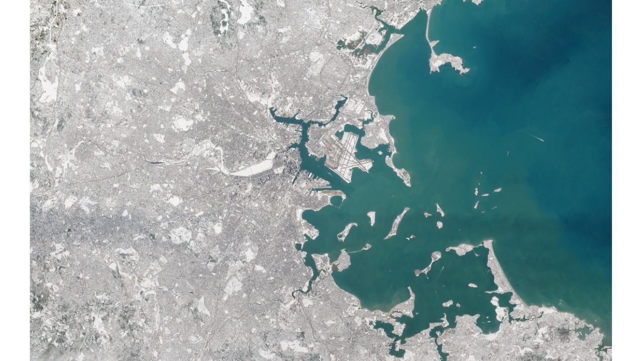
BOSTON, MASSACHUSETTS — A striking high-resolution satellite image captured from approximately 488 miles above Earth is offering a rare and detailed look at the scale of snow and ice blanketing the Boston metro area.
The imagery reveals a city coated in white, with frozen landscapes stretching across neighborhoods, waterways, and surrounding communities.
Boston Harbor and Surrounding Communities Covered in Snow
The satellite view clearly shows:
- Boston Harbor
- Logan International Airport
- The Charles River
- Surrounding coastal communities
- Portions of South Boston, Cambridge, Quincy, and Dorchester
From space, snow cover appears widespread across rooftops, streets, and open areas, while the harbor’s deep blue-green waters contrast sharply with the bright winter landscape.
Several of the harbor islands and peninsulas are visibly snow-covered, highlighting just how expansive the storm’s footprint has been.
Logan International Airport Visible Beneath Snow-Covered Surroundings
The runways at Logan International Airport stand out prominently in the image, appearing partially cleared but surrounded by snow-covered infrastructure and surrounding land.
Airports often prioritize runway treatment during winter storms, which is why the pavement appears darker compared to the surrounding snow-covered surfaces.
Urban Snow Pack Stands Out From Space
It has been some time since Boston has displayed such a high-resolution satellite presentation of widespread snow and ice coverage.
The image highlights:
- Heavy accumulation across densely packed urban neighborhoods
- Snow coverage extending well inland from the coast
- Ice and frozen patches along smaller waterways
The clarity of the image makes it evident how thoroughly the region has been impacted.
Regional Context
Beyond Boston itself, snow coverage extends across much of eastern Massachusetts. The surrounding land areas appear uniformly white, suggesting consistent accumulation rather than patchy snowfall.
From 488 miles above Earth, the extent of the winter storm’s reach becomes more apparent than ground-level views can capture.
Why Satellite Imagery Matters
High-resolution satellite imagery serves several purposes:
- Confirms snow extent and coverage
- Helps assess post-storm impacts
- Assists in regional situational awareness
- Provides documentation of significant weather events
These images are especially valuable after large-scale winter storms when assessing infrastructure, transportation, and coastal impacts.
Reminder for North Carolina Readers
While this particular event occurred in Massachusetts, it underscores how powerful winter systems can reshape entire metropolitan areas overnight.
For North Carolina residents, especially in the Piedmont and foothills, similar large-scale snow or ice events — while less frequent — can produce comparable widespread impacts.
CabarrusWeekly.com will continue monitoring significant weather events nationwide and provide updates whenever large-scale systems threaten the Carolinas.