California and Nevada Face Powerful Atmospheric River as Heavy Rain Targets Sierra Nevada Snowpack but Widespread Flooding Not Yet Expected
CALIFORNIA — After last week’s heavy and disruptive snowfall across the Sierra Nevada, a powerful and unusually warm atmospheric river is now taking aim at the state, set to deliver substantial rainfall — even at higher elevations where deep snowpack remains in place.
Forecast guidance shows a concentrated plume of Pacific moisture streaming into central and northern California, with the strongest moisture transport directed toward the Sierra Nevada and nearby foothills.
Strong Moisture Plume Aimed at the Sierra
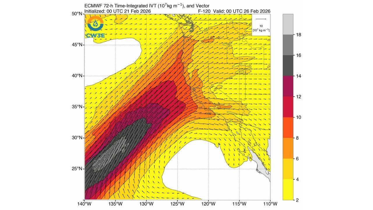
The latest model projections highlight a 72-hour period of intense integrated vapor transport pushing northeast from the Pacific into California. The core of the atmospheric river appears focused near the central California coast before lifting inland toward the Sierra Nevada.
This type of setup allows warm, moisture-rich air to override mountain snowpack, producing rainfall at elevations that recently saw heavy snow accumulation.
Communities from Sacramento eastward into the Sierra foothills and mountain corridors could see significant runoff as rain falls directly onto snow-covered terrain.
Why Widespread Serious Flooding Is Not Expected — For Now
Despite the strength of the moisture plume, widespread major flooding is not currently anticipated. There are several key reasons:
- Rivers are not starting from extreme flood levels.
- Snowpack conditions may initially absorb some of the rainfall.
- The duration of the most intense moisture transport appears limited to a defined window rather than a prolonged multi-day event.
However, localized flooding, rapid snowmelt runoff, and rising creeks remain possible, particularly in lower elevations and areas downstream of steep terrain.
Elevated Rainfall Even at High Elevations
One of the most notable aspects of this system is the warmth of the incoming air mass. Rain is expected at elevations that would typically see snowfall during a colder storm.
That means parts of the higher Sierra Nevada could transition from snow to rain, accelerating melting and increasing runoff efficiency.
Areas west of the crest, including mountain communities and river basins feeding into the Central Valley, will need to monitor water levels closely.
Short-Term Risk, Longer-Term Watch
At this time, forecasting centers indicate that while hydrologic impacts are possible, the probability of widespread, serious flooding remains limited.
Still, atmospheric river events are dynamic and can shift in strength or duration. Should rainfall totals trend higher than currently projected, river forecasts may be adjusted accordingly.
Residents across California and western Nevada should stay alert for updated rainfall and river stage forecasts as the system approaches.
For continuing coverage of major weather systems impacting the western United States, visit CabarrusWeekly.com and share conditions from your area.