California, Nevada, Arizona, Texas and Colorado Heat Wave Expands While North Carolina, Virginia and East Coast See Break From Severe Storms
UNITED STATES — After days of dangerous storms, a major shift in the national weather pattern is now underway, bringing a temporary break from severe weather across North Carolina and much of the East Coast, while a significant heat wave expands across multiple western states including California, Nevada, Arizona, Texas, and Colorado.
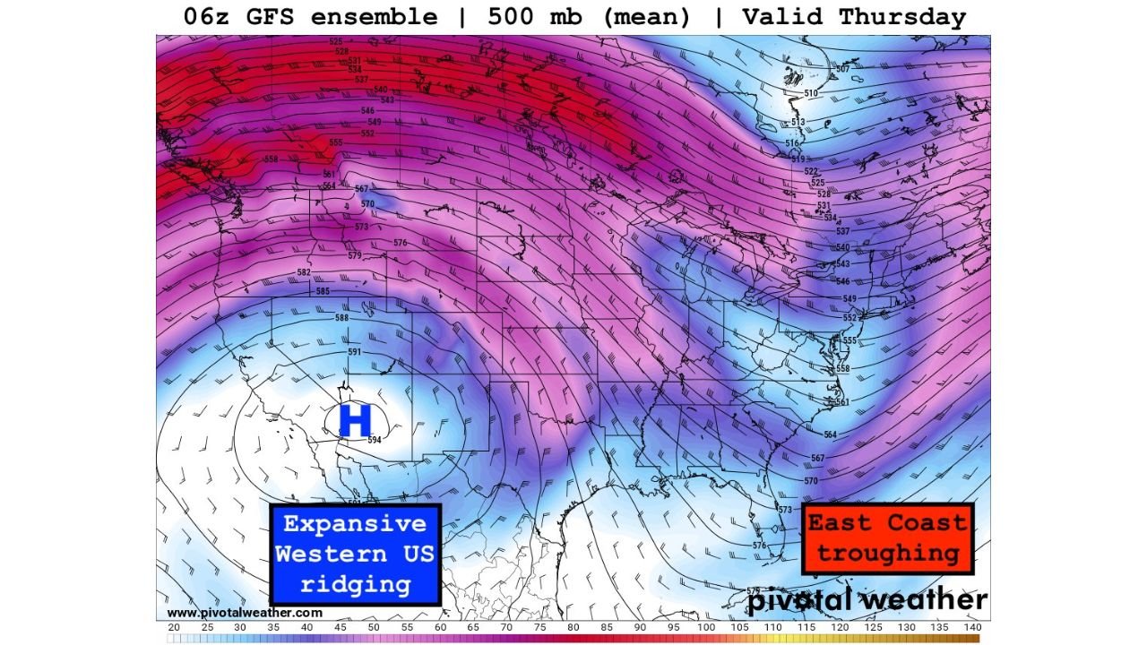
Meteorologists say this setup is being driven by a strong atmospheric divide, with high pressure building over the western U.S. and a lingering trough pattern holding across the East Coast.
Severe Storm Threat Drops Across North Carolina and the East Coast
Following recent rounds of severe weather, conditions are expected to stabilize across North Carolina, Virginia, South Carolina, and surrounding states, significantly reducing the likelihood of widespread severe storms.
The shift in pattern limits the ingredients needed for organized thunderstorms, meaning fewer severe weather alerts and a calmer stretch of weather across the region.
Cities including Charlotte, Raleigh, Greensboro, and Richmond are expected to see more stable conditions compared to recent days.
Western States Heat Wave Intensifies Rapidly
At the same time, a powerful ridge of high pressure is building across the western United States, allowing temperatures to surge well above normal.
The most intense heat is expected across:
- California
- Nevada
- Arizona
- New Mexico
- Texas
- Colorado
In these areas, temperatures could climb 15 to 30 degrees above seasonal averages, with some desert locations pushing into the triple digits.
Cities such as Phoenix, Las Vegas, Tucson, El Paso, Denver, and Fresno may experience some of the hottest conditions during this early-season heat event.
Record High Temperatures Possible in Several States
Meteorologists warn that this prolonged heat could lead to record-breaking temperatures, especially in parts of the Southwest and interior West.
The strength of the high-pressure system will trap heat and suppress cloud formation, allowing temperatures to rise steadily through the week.
This type of pattern is known for producing long-duration heat waves, which can increase stress on energy systems and pose health risks, particularly in urban and desert regions.
East Coast Remains Cooler Under Persistent Trough Pattern
While the West heats up, the eastern United States will remain under a cooler and somewhat unsettled pattern, though without widespread severe weather.
States including North Carolina, Virginia, Maryland, and Pennsylvania may continue to see:
- Periods of clouds
- Occasional showers
- Breezy conditions
However, the absence of strong instability means severe storms are expected to remain limited during this period.
Pattern Expected to Hold Before Possible Late-March Changes
Forecast models suggest this split weather pattern — heat dominating the West and cooler, quieter conditions in the East — could persist for at least the next several days.
There are indications that the pattern may shift again toward the end of March, potentially allowing more active weather to return.
For now, the United States is entering a temporary calm period in storm activity, even as a major heat wave builds across several western states.
Stay with CabarrusWeekly.com for the latest updates on changing weather conditions across North Carolina and the United States.