California, Nevada, Sierra Nevada Brace for Midweek Storm Bringing Rain, Mountain Snow and Falling Snow Levels
CALIFORNIA, NEVADA — A midweek weather shift is expected to bring rain and accumulating mountain snow across parts of California and Nevada, with conditions turning more active Wednesday night into Thursday morning, especially in higher elevations like the Sierra Nevada.
After a brief stretch of milder and drier weather early in the week, this incoming system signals a return to more unsettled conditions.
Drier and Milder Conditions Before the Storm Arrives
The early part of the week, particularly Tuesday into early Wednesday, is expected to remain relatively calm across the region.
Forecast signals show:
- A drier trend across much of California and Nevada
- Light rain and snow showers possible, mainly in higher terrain
- Snow levels remaining high, generally above 7,000 to 8,000 feet
This means most lower elevations will see minimal impacts initially, with precipitation largely confined to mountainous areas.
Stronger Storm Develops Late Wednesday Into Thursday
Conditions begin to change more noticeably Wednesday night, as a colder and more organized system moves in from the Pacific.
Key impacts expected:
- Increased precipitation coverage across Northern and Central California
- Expanding rain into valleys and lower elevations
- Snow developing across the Sierra Nevada and nearby ranges
The timing suggests the most active period will occur overnight Wednesday into early Thursday, when colder air fully settles in.
Snow Levels Drop as Colder Air Moves In
One of the most important changes with this system will be falling snow levels, which could expand snowfall impacts.
- Early in the event: Snow levels near 7,000–8,000 feet
- Later Wednesday night: Dropping closer to 6,000–7,000 feet
As colder air deepens, more mountain communities could see accumulating snowfall instead of rain.
Several Inches of Snow Likely in Higher Elevations
The Sierra Nevada stands out as the primary area for meaningful snowfall.
Current projections indicate:
- Several inches of snow possible in higher elevations
- Heavier snowfall focused along the Sierra crest and higher peaks
- Lower totals in foothills due to initially higher snow levels
This type of setup is typical when colder air arrives behind a midweek system, enhancing snowfall rates overnight.
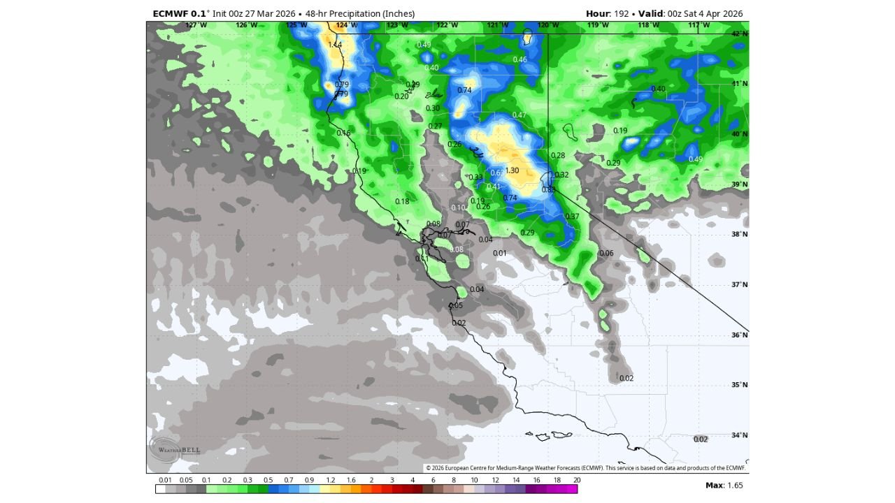
Rainfall Spreads Across Lower Elevations
Outside of the mountains, much of California and parts of Nevada are expected to see widespread rain.
The precipitation map indicates:
- Moderate rainfall across Northern California and the Sierra foothills
- Lighter totals extending into Southern California and western Nevada
- Patchy precipitation further south with lower overall totals
While not an extreme rain event, it will bring a noticeable shift from recent dry conditions.
What This Means for Travel and Outdoor Plans
This midweek system could impact travel, particularly in mountain regions:
- Snow-covered roads possible in higher elevations
- Reduced visibility during heavier snowfall periods
- Wet roadways and slick conditions in lower elevations
Travelers heading through mountain passes should be prepared for rapidly changing conditions overnight.
Pattern Remains Active Into Early April
This system is part of a broader trend showing continued active weather across the western United States, with additional systems possible beyond this event.
While this storm may not be extreme, it reinforces a pattern of:
- Periodic Pacific systems moving inland
- Fluctuating snow levels
- Ongoing chances for mountain snowfall
Stay with CabarrusWeekly.com for further updates as this midweek storm approaches and conditions become clearer.