California Sierra Nevada Braces for Prolonged Winter Surge as Multiple Storms Target Crest With Up to 10 Feet of Snow
CALIFORNIA — Winter is making a strong return across the western United States as a prolonged storm pattern lines up to deliver exceptional snowfall totals across California’s Sierra Nevada, with the most intense impacts focused along the crest and western slopes through the next 10 days.
Multi-Storm Pattern Locks Onto the Sierra Nevada
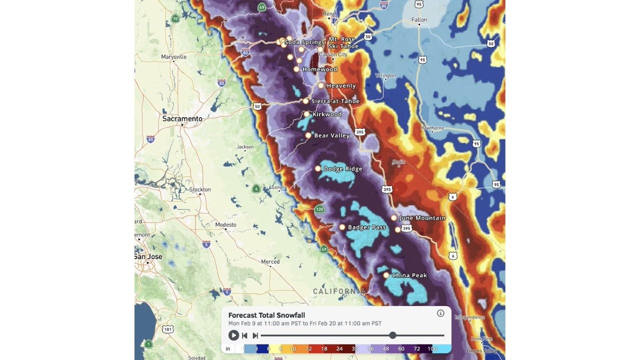
Forecast snowfall data shows a persistent and moisture-rich storm track repeatedly slamming into the Sierra Nevada, allowing snow to accumulate with little time to melt or compact between systems. This is not a single storm event, but rather a series of snow-producing systems reinforcing cold air and deep moisture over the same terrain.
The highest elevations along the Sierra crest are projected to receive 5 to 10 feet of total snowfall, driven by strong orographic lift as Pacific moisture is forced up and over the mountain range.
Crest and Western Slopes Face the Heaviest Totals
The most extreme snowfall is expected along the crest and western-facing slopes, where deep purple and blue shading on forecast maps highlights the potential for multiple feet of snow piling up in layers. These areas are particularly vulnerable due to sustained upslope flow, which maximizes snow production over long durations.
Snowfall rates during peak periods could become intense enough to severely reduce visibility and overwhelm road-clearing operations, especially at higher passes.
Mountain Communities Prepare for Significant Impacts
Several well-known mountain communities and resort areas are directly in the bullseye of this prolonged winter pattern. Locations including Tahoe City, Soda Springs, Homewood, Heavenly, Kirkwood, Bear Valley, Dodge Ridge, Badger Pass, June Mountain, and China Peak are forecast to see 2 to 4+ feet of snow, with locally higher amounts possible depending on elevation and storm timing.
These totals are spread across multiple days, increasing the likelihood of extended travel disruptions, temporary road closures, and challenging conditions for emergency services.
Snowfall Timeline Extends Through Mid-February
Forecast data indicates this snow accumulation window stretches from early in the week through at least February 20, meaning impacts will be ongoing rather than confined to a short event. Each new system reinforces snowpack depth, adding weight and increasing avalanche concerns in steep terrain.
Lower elevations west of the Sierra will see a sharp cutoff in snowfall, emphasizing how elevation-dependent this event will be.
What This Means for California’s Winter Outlook
This developing pattern signals that winter is firmly reasserting itself in California’s high country, with snowpack levels poised to increase substantially. While beneficial for long-term water resources, the short-term risks include dangerous travel, structural snow loading, and prolonged mountain isolation in some communities.
Residents, travelers, and recreation enthusiasts should be prepared for rapidly changing conditions and extended winter hazards as this pattern unfolds.
CabarrusWeekly.com will continue monitoring national and regional weather trends and provide updates as new data refines snowfall totals and timing. Readers with family, travel plans, or interests in the western mountains are encouraged to stay alert and share conditions as this major winter surge develops.