California’s Central Sierra Snow Lab Surges Above Normal After 9 Feet of Snow in One Week, Boosting Reservoir Outlook for Summer
CALIFORNIA — For the first time since early January, the Central Sierra Snow Lab (CSSL) is now reporting accumulated snowfall above the 1991–2020 median, following an extraordinary week that delivered more than 9 feet of snow to the high elevations of the Sierra Nevada.
The dramatic surge in snowfall marks a significant turnaround in the water year and could have important implications for California’s spring and summer water supply.
Snowfall Totals Now Exceed Seasonal Median
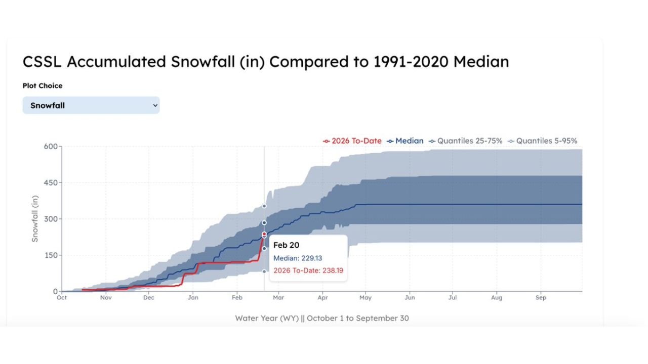
As of February 20, accumulated snowfall at the Central Sierra Snow Lab reached 238.19 inches, compared to a historical median of 229.13 inches for the same date.
The recent storms pushed the 2026 seasonal snowfall curve above the long-term average line for the first time in several weeks. Earlier in the winter, totals had fallen below the median, raising concerns about long-term water availability.
The rapid climb reflects the impact of back-to-back Pacific systems that brought prolonged snowfall to higher elevations.
Over 9 Feet in One Week Changes the Outlook
Receiving more than 9 feet of snow in a single week is a major event, even for the Sierra Nevada. Such intense snowfall significantly increases snow water equivalent — the amount of water stored within the snowpack.
This is crucial because Sierra snowpack acts as California’s natural reservoir system. As temperatures warm in the spring, gradual snowmelt feeds rivers and replenishes reservoirs across the state.
Without sufficient snowpack, California can face water shortages during late spring and summer when rainfall becomes scarce.
Why Sierra Snowfall Matters So Much
The Sierra Nevada supplies water to millions of Californians and supports agriculture throughout the Central Valley. Snow accumulation during winter directly influences:
- Reservoir levels heading into summer
- Irrigation supply for farms
- Hydropower generation
- Urban water allocations
With no meaningful rainfall during the dry summer months, the state relies heavily on slow, steady snowmelt to sustain water systems.
A Positive Shift, But More Winter Ahead
While the snow lab is now above median for the date, the water year continues through September 30. Additional storms — or extended dry spells — could still shift the trajectory.
However, this latest surge provides a meaningful buffer after earlier seasonal concerns.
For now, the Central Sierra snowpack is back above normal — a welcome development for California’s long-term water outlook.
For continued updates on western U.S. snowpack and water supply trends, visit CabarrusWeekly.com and share how winter weather is impacting your region.