Canadian Clipper Reloads New England Winter as Boston Tracks Another Midweek Snowfall Burst
MASSACHUSETTS — Winter refuses to loosen its grip on New England as another Canadian Clipper system drops southeast from Canada, bringing a fresh round of snowfall to Boston and surrounding areas Wednesday afternoon into the evening.
Fast-Moving Clipper Targets Southern New England
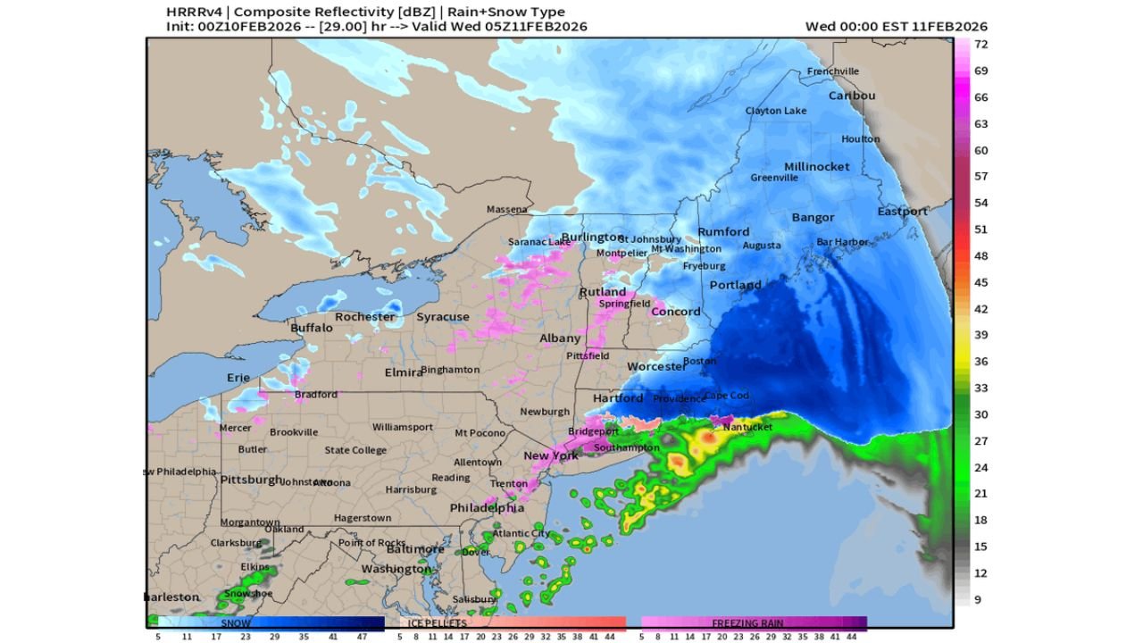
Forecast guidance shows a compact but efficient Clipper system sweeping across New England, producing widespread light-to-moderate snow in a relatively short window. These systems are known for quick bursts of snowfall, gusty winds, and rapid changes in road conditions, even when totals remain moderate.
Boston and much of eastern Massachusetts sit squarely within the snow shield as the system pushes offshore late Wednesday night.
Boston Snow Totals Expected to Add Up Quickly
Current snowfall projections indicate 3 to 4 inches of fresh snow for Boston and nearby communities, enough to create slick travel during the afternoon commute and early evening hours. Snow is expected to fall efficiently with cold air firmly in place, limiting any mixing concerns for inland areas.
While this is not a blockbuster storm, the timing and temperature profile favor steady accumulation in a short period.
Higher Elevations See Locally Heavier Snow
Across interior New England and elevated terrain, snowfall totals increase. Forecast data suggests 6 to 8 inches of snow is possible in the mountains, where colder air and enhanced lift support higher accumulation rates.
These areas may experience brief periods of reduced visibility and snow-covered roads as the Clipper passes through.
Coastal Impacts and Precipitation Gradient
Along the immediate southern New England coastline, precipitation may flirt with a rain-snow mix offshore, but Boston and most inland locations remain cold enough for all snow. A sharp cutoff is expected south of the snow band, reinforcing how narrow but impactful this Clipper will be.
Snowfall intensity diminishes quickly once the system exits to the east, allowing colder and quieter conditions to settle back in overnight.
What This Means Going Forward
This event reinforces an active winter pattern across New England, where frequent Clipper systems continue to add snow in manageable but cumulative increments. Even modest totals contribute to snowpack growth, icy conditions, and ongoing winter maintenance challenges across the region.
CabarrusWeekly.com will continue monitoring national weather patterns and their regional impacts. If you have family, travel plans, or weather observations from New England during this midweek snowfall, share your experience and stay connected with CabarrusWeekly.com for continued weather coverage.