Central Illinois Could See Early Evening Severe Storm Cluster Thursday as Conditional Risk Focuses Near Springfield, Peoria and Decatur
ILLINOIS — While a widespread severe weather outbreak appears unlikely Thursday, high-resolution guidance continues to show a conditional but organized cluster of storms developing early Thursday evening across central Illinois, with the potential for strong to severe impacts.
Height Rises and Warm Air Aloft Limiting Larger Outbreak
Forecast analysis indicates that height rises and warming mid-level temperatures may suppress a more expansive severe weather event across the broader Midwest and Ohio Valley. That cap could limit overall storm coverage.
However, if storms are able to initiate, the environment remains supportive of severe weather, especially where low-level moisture and stronger wind fields overlap. This creates a scenario where fewer storms form, but any that do develop could intensify quickly.
The setup is conditional, meaning storm coverage may be scattered, but localized impacts could still be significant.
Storm Cluster Signal Focused on Central Illinois
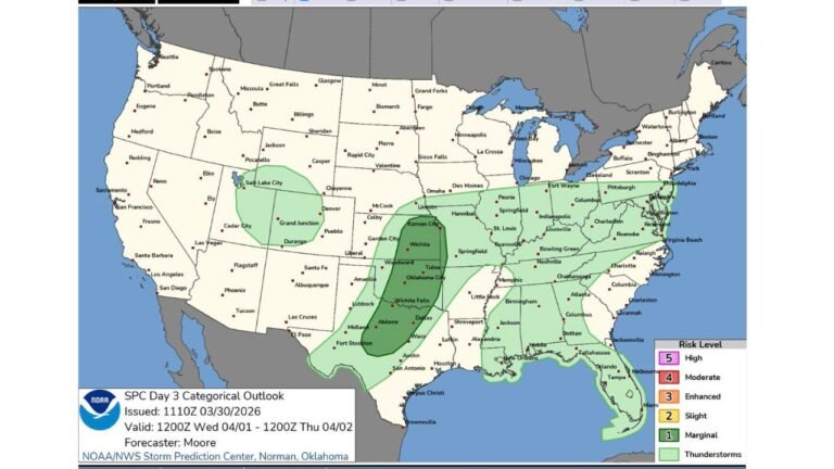
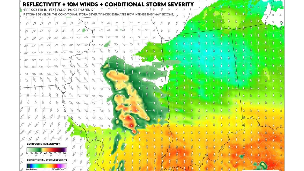
High-resolution model reflectivity guidance highlights a developing storm cluster near Springfield, Peoria, Decatur, Bloomington, and Champaign during the early evening hours Thursday.
The corridor of concern stretches from west-central Illinois eastward toward the Illinois-Indiana border, with the strongest storms potentially organizing along a dryline-like boundary. Wind fields appear supportive of organized convection, particularly across central Illinois.
If storms form in this zone, they could evolve into semi-organized clusters capable of producing damaging wind gusts and large hail, with isolated tornado potential not completely ruled out.
Southern Illinois Into Indiana Also Under Watch
Farther south, areas including Effingham, Mount Vernon, and portions of southern Illinois into southwest Indiana show a background environment supportive of stronger storms, particularly where deeper moisture overlaps stronger wind shear.
While overall moisture remains somewhat limited compared to classic spring setups, model output still indicates pockets of conditional storm severity across southern and eastern Illinois extending into western Indiana.
The highest conditional severity values are located south and east of the central Illinois cluster, suggesting that storms tracking into that air mass could intensify briefly.
Highly Conditional but Worth Monitoring
The key limiting factor remains moisture quality and mid-level warming. If moisture is shallower than expected or the cap holds firm, storm coverage may remain isolated.
However, if storms break through the cap during peak heating Thursday afternoon and evening, the environment across central Illinois into western Indiana would support organized severe storms.
Residents across Illinois should monitor updated forecasts Thursday, particularly in the Springfield–Peoria–Decatur corridor, where early evening development appears most likely.
If you experience strong storms in your area Thursday, share your conditions with CabarrusWeekly.com as we continue tracking this evolving severe weather setup.