Central Long Island Leads with 8 Inches as Coastal Snow Bands Strengthen Across Northeast; Storm Still Has “Long Way to Go”
NORTHEAST UNITED STATES — Snow is steadily piling up across parts of the Northeast, and early reports show Central Long Island topping the charts so far with 8 inches, while additional accumulation is expected as the system continues to intensify.
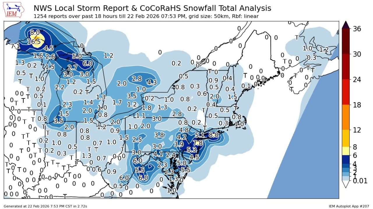
According to the latest NWS Local Storm Report and CoCoRaHS snowfall analysis, over 1,200 reports have been logged within the past 18 hours, revealing a broad swath of measurable snow from the Mid-Atlantic through New England.
Long Island Sees Early Maximum Totals
Central Long Island currently holds the highest confirmed total at 8.0 inches, with surrounding areas across Long Island reporting widespread 5 to 7 inch totals.
Snowfall across:
- New York City and surrounding boroughs ranges generally from 1 to 3 inches so far.
- Northern New Jersey is seeing lighter totals, mostly under 2 inches.
- Southern Connecticut and parts of coastal New England remain under lighter accumulations at this stage.
Forecasters note this is an evolving situation, and heavier coastal bands may redevelop overnight.
Heavier Snow Extends South Into Mid-Atlantic
Snow totals are not limited to New York. The analysis shows:
- Eastern Pennsylvania with pockets of 3 to 5 inches.
- Southern New Jersey reporting 4 to 6 inches in some areas.
- Northern Delaware and northeastern Maryland seeing several 2 to 4 inch totals.
- Portions of Virginia reporting lighter but steady accumulations.
Farther inland across western Pennsylvania and upstate New York, totals are more varied, generally in the 1 to 4 inch range.
Storm Structure Suggests More to Come
Radar and snowfall distribution indicate the storm remains organized offshore, with coastal banding still active. The heaviest snow so far has been concentrated along the Long Island and southern New England corridor, where moisture wrapping around the coastal low continues feeding into persistent snow bands.
Meteorologists caution that:
- Snowfall rates may increase in coastal zones.
- Wind gusts could enhance blowing and drifting.
- Additional inches are likely before the system pulls away.
The phrase “long way to go” reflects the fact that snowfall totals remain preliminary and could rise significantly, especially in banding zones.
Impact on North Carolina and Cabarrus County
For Cabarrus County and central North Carolina, this storm remains a distant system. No direct snowfall impacts are expected locally. However, strong Northeast coastal systems often influence broader regional weather patterns, sometimes leading to cooler and breezy conditions after passage.
Residents in Cabarrus County should continue monitoring local forecasts, but no winter weather disruptions are currently indicated for the area.
A Developing Northeast Winter Event
With 8 inches already recorded in Central Long Island and several 5 to 7 inch totals nearby, the storm is clearly producing impactful snowfall. As coastal bands persist and the low remains active offshore, additional accumulation is likely across parts of the Northeast.
Cabarrus Weekly will continue tracking this developing winter storm and provide updates if any downstream weather shifts affect North Carolina.
Stay with CabarrusWeekly.com for the latest weather updates and regional coverage.