Classic ‘Monster’ New England Blizzard Unleashes 20+ Inches, Hurricane-Force Gusts and Possible Thundersnow Along Massachusetts and Rhode Island Coast
NEW ENGLAND COAST — A powerful and intensifying Nor’easter is slamming the Massachusetts and Rhode Island coastline with blizzard conditions, heavy snowfall rates, and strengthening winds that could reach hurricane-force gusts as the storm enters its peak phase.
Forecasters describe this as a “classic, monster New England blizzard,” with more than 20 inches of snow expected in parts of eastern Massachusetts and Rhode Island. Winds are already ramping up along the coastline, with the most severe impacts likely over the next several hours.
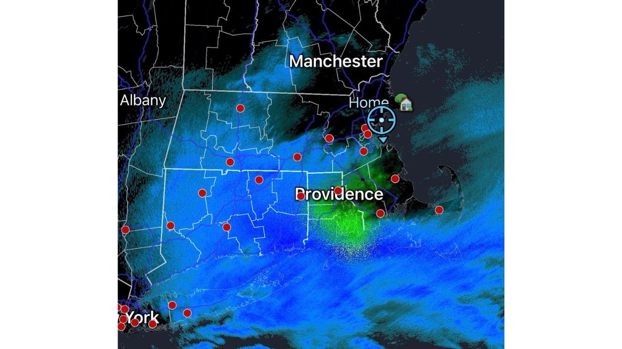
Heavy Snow Expanding from Providence to Manchester
Radar imagery shows widespread heavy snow stretching from Providence, Rhode Island, northward through eastern Massachusetts and into southern New Hampshire, including areas near Manchester.
Key impacts include:
- Snowfall rates capable of exceeding 2 inches per hour.
- Rapidly deteriorating visibility due to blowing snow.
- Dangerous travel conditions across coastal counties.
- Intensifying wind bands pushing inland.
The heaviest returns on radar are concentrated near the Rhode Island and southeastern Massachusetts coastline, suggesting the most intense snow bands are pivoting across the coastal plain.
Hurricane-Force Gusts Possible Along the Coast
As the storm strengthens offshore, the pressure gradient continues to tighten. That is translating into increasingly strong winds along coastal Massachusetts, Cape Cod, and Rhode Island.
Meteorologists warn:
- Wind gusts could approach or exceed hurricane force in exposed coastal areas.
- Blizzard criteria — sustained winds or frequent gusts over 35 mph with falling/blowing snow — is already being met in multiple locations.
- Coastal flooding and power outages are likely as wind speeds increase.
The storm is expected to intensify further before reaching its peak, meaning the worst conditions may still be ahead for parts of the coastline.
Thundersnow Potential Adds to the Intensity
With strong convection developing within the snow bands, forecasters say isolated thundersnow is possible. Thundersnow occurs when intense upward motion within a snowstorm generates lightning and thunder — often coinciding with extremely heavy snowfall rates.
If thundersnow develops, snowfall could briefly intensify to extreme levels, dramatically reducing visibility and creating whiteout conditions.
How This May Influence North Carolina’s Weather Pattern
Although this Nor’easter is focused on New England, large coastal storms can influence broader atmospheric patterns.
After major East Coast cyclones:
- Cold air often strengthens behind the departing system.
- The jet stream can shift, occasionally influencing temperatures in the Southeast.
- Breezy and cooler conditions sometimes follow in the Carolinas.
For Cabarrus County, there are no direct impacts expected from this New England blizzard. However, meteorologists will monitor how the storm’s departure reshapes regional temperature trends later this week.
A High-Impact Event for the Northeast
With projections exceeding 20 inches in some areas and hurricane-force wind gust potential along the coastline, this storm ranks among the more significant New England blizzards in recent memory.
Travel across eastern Massachusetts, Rhode Island, and coastal New Hampshire is expected to remain extremely hazardous through the storm’s peak. Residents in affected areas are urged to stay indoors and monitor official guidance.
Cabarrus Weekly will continue tracking any downstream impacts from this powerful coastal storm.
Stay with CabarrusWeekly.com for continued weather updates and local forecast coverage.