Colorado Mountains Line Up for Midweek Snow Surge as Heaviest Accumulation Targets High Country North of Highway 50
COLORADO — A developing winter system is set to bring a two-phase snow event across Colorado, with light mountain snow beginning first and heavier, more impactful snowfall arriving Wednesday into Thursday, particularly across higher elevations and areas along and north of Highway 50.
Light Snow Begins Ahead of Stronger Midweek Push
Forecast guidance shows light mountain snow developing first, serving as a lead-in to a more organized round of winter weather. While initial accumulations will be modest, they will help prime road surfaces and increase slick travel conditions at elevation before the main surge arrives.
Lower elevations, including the Front Range and eastern plains, remain largely dry during this early phase.
Heaviest Snow Targets Colorado High Country Wednesday and Thursday
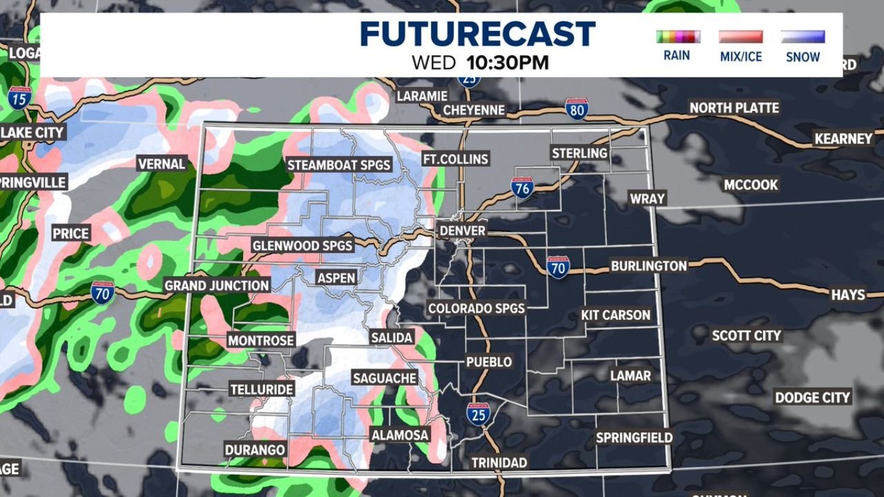
The core of this system arrives Wednesday into Thursday, when colder air and improved lift combine to produce solid snowfall across Colorado’s mountains. Accumulation totals of 4 to 12 inches are expected across much of the high country, with the highest totals focused along and north of Highway 50.
Mountain corridors near Steamboat Springs, Glenwood Springs, Aspen, Telluride, Salida, and surrounding terrain fall within the most consistent snow band, where snowfall rates may periodically increase during peak periods.
Elevation Plays a Major Role in Accumulation
Snowfall intensity and totals increase rapidly with elevation. Higher passes and ridgelines will see persistent snow, while valley locations may experience occasional mixing before colder air fully settles in. This elevation-driven contrast will create challenging travel conditions on mountain roads, particularly overnight and early morning hours.
Denver and Front Range Impacts Remain Limited
Unlike the mountains, Denver and much of the Front Range are expected to see only light rain or snow from Thursday afternoon into Friday. Forecast data indicates minimal accumulation, and this portion of the system does not appear to be a major concern for metro-area travel or infrastructure.
Any precipitation that does occur in Denver should be brief and light, with little disruption expected.
What to Expect Through the End of the Week
As the system exits late Thursday into Friday, snowfall tapers across the mountains while colder, quieter conditions follow. While this event is not extreme by Colorado standards, it reinforces an active winter pattern for the high country, especially for regions favored by northwest flow and higher terrain.
Travelers planning mountain trips should be prepared for snow-covered roads, reduced visibility, and changing conditions, particularly during the Wednesday–Thursday peak.
CabarrusWeekly.com will continue monitoring national weather patterns and their impacts across the country. If you’re traveling through Colorado’s mountains or hearing from friends and family in the region, share what you’re seeing and stay connected with CabarrusWeekly.com for continued weather coverage.