Dangerous Severe Weather Outbreak Targets Illinois Indiana Ohio and Michigan With Tornadoes and Baseball Size Hail Thursday
MIDWEST UNITED STATES — A potentially dangerous severe weather setup is expected to unfold Thursday across the Midwest and Ohio Valley, bringing threats of tornadoes, destructive winds, and very large hail during the afternoon and evening hours.
Severe Weather Risk Expands Across Midwest and Ohio Valley
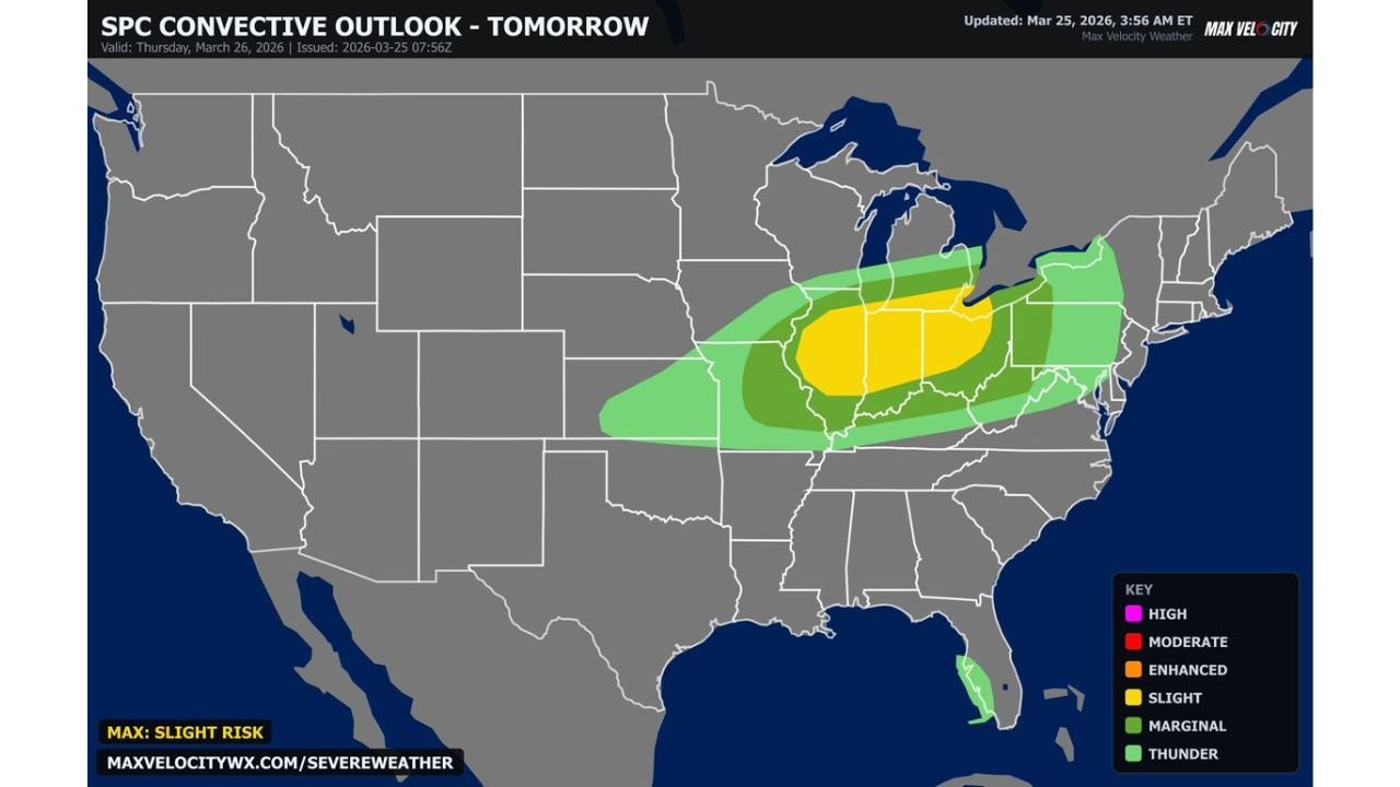
Forecast guidance highlights a Slight Risk zone centered over Illinois, Indiana, Ohio, and parts of Michigan, with surrounding areas including Missouri, Kentucky, and Pennsylvania also under threat for storms.
Major cities such as Chicago, Indianapolis, Fort Wayne, Columbus, Cleveland, and Detroit fall within the core risk region where conditions appear most favorable for strong storm development.
Baseball Size Hail Emerges as Major Concern
One of the biggest threats with Thursday’s setup is very large hail, especially during the early stages of storm development.
Initial storms are expected to form as discrete supercells, which are known for producing hail as large as baseballs. These storms will have strong updrafts capable of suspending hailstones long enough to grow to significant sizes before falling.
Tornado Risk Present With Stronger Storms
Alongside the hail threat, there is also potential for a few strong tornadoes, particularly during the early phases when storms remain isolated.
As storms organize and interact, the tornado risk may transition, but embedded tornadoes could still occur within storm clusters later in the evening.
Storm Timeline Shows Long Duration Threat
Timing is a key factor in Thursday’s severe setup:
Storms may begin developing as early as 2 PM
Peak severe window likely between late afternoon and evening
Storm activity expected to continue until around midnight
By 6–7 PM, initial supercells are expected to merge into clusters or lines, shifting the primary threat toward damaging winds and widespread impacts.
Damaging Winds Add To Multi-Hazard Event
As storms evolve into larger complexes, strong and potentially damaging wind gusts will become a growing concern.
These winds could lead to power outages, tree damage, and hazardous travel conditions, especially during the evening commute hours.
Areas Facing Highest Impact
The most intense weather is expected across:
Central and eastern Illinois
Much of Indiana
Western and central Ohio
Southern Michigan
This region represents the strongest overlap of instability, moisture, and wind shear — the key ingredients for severe thunderstorms.
What Makes This Setup Concerning
This system stands out due to its combination of multiple hazards occurring within a short time frame, including:
Large hail early in the event
Tornado potential with discrete storms
Damaging winds as storms merge and expand
The transition from isolated to clustered storms means impacts could become more widespread as the evening progresses.
Final Outlook
Thursday’s weather setup has the potential to produce significant severe weather across several highly populated Midwest states, with conditions supporting tornadoes, large hail, and damaging winds.
Residents in Illinois, Indiana, Ohio, and Michigan should remain alert throughout the day and into the night as storms rapidly develop and move through the region.
Stay with CabarrusWeekly.com for continuing updates as this severe weather event unfolds.