Dangerous Severe Weather Outbreak Targets Texas, Oklahoma, Missouri and Illinois Today as Strong Tornado and Giant Hail Threat Peaks
UNITED STATES — A dangerous severe weather outbreak is unfolding today from Texas through the Midwest, with very large hail, damaging winds and a few strong tornadoes likely as storms intensify this afternoon and evening.
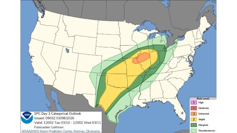
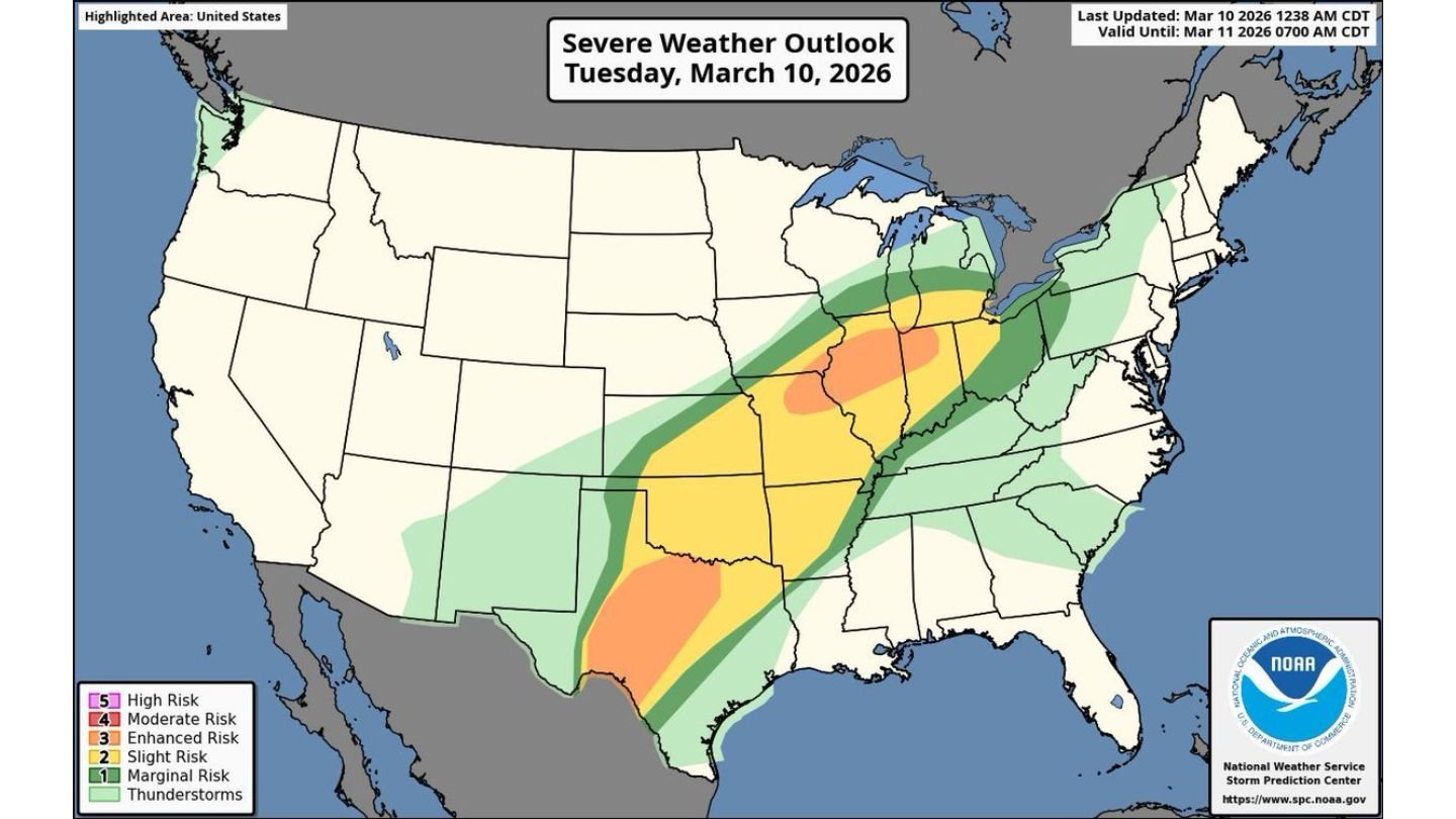
The latest severe weather outlook for Tuesday, March 10 highlights a broad corridor of risk stretching from south Texas through Oklahoma, Missouri, Illinois and into parts of Indiana and Michigan.
Highest Concern from Texas to Illinois
The most concentrated severe threat appears across:
- Central and eastern Texas
- Oklahoma
- Missouri
- Illinois
- Indiana
A more focused area of heightened concern is centered over:
- Eastern Texas
- Arkansas
- Missouri
- Central and northern Illinois
Cities near the core of the higher-impact zone include:
- Dallas, TX
- Austin, TX
- Oklahoma City, OK
- Little Rock, AR
- St. Louis, MO
- Springfield, IL
- Peoria, IL
Main Threats: Giant Hail, Strong Winds, Tornadoes
Forecasters warn that very large hail is possible, especially in discrete supercells that develop ahead of any main storm line. Some hailstones could reach significant size with the strongest storms.
In addition, damaging straight-line winds are likely as storms organize and potentially evolve into larger clusters or lines later this evening.
A few strong tornadoes are also possible, particularly in areas where storms remain isolated long enough to tap into favorable wind shear and instability.
Busy Afternoon and Evening Ahead
The most active period is expected to occur:
- Mid to late afternoon
- Through the evening hours
- Potentially continuing into the overnight period
Storms may initially form as isolated supercells across parts of Texas and Oklahoma before spreading northeast into Missouri and Illinois.
As the system progresses, storms could grow more widespread, increasing the overall impact footprint.
Expanding Risk Into the Great Lakes
Farther north, the severe risk extends into parts of:
- Indiana
- Michigan
While the highest tornado potential appears farther south, damaging winds and hail remain possible into these northern areas as the storm system lifts northeast.
Large Population in the Risk Zone
More than 100 million people are within the broader severe weather area today, emphasizing the scale of this outbreak.
With such a large geographic footprint, multiple rounds of storms may impact different regions at different times.
Bottom Line
A dangerous severe weather outbreak is likely today from Texas through Oklahoma, Missouri and Illinois, with very large hail, damaging winds and a few strong tornadoes possible. The most intense storms are expected this afternoon and evening.
Residents across the central U.S. should ensure they have multiple ways to receive weather alerts and stay tuned for rapidly changing conditions as this active severe weather day unfolds. CabarrusWeekly.com will continue providing updates throughout the event.