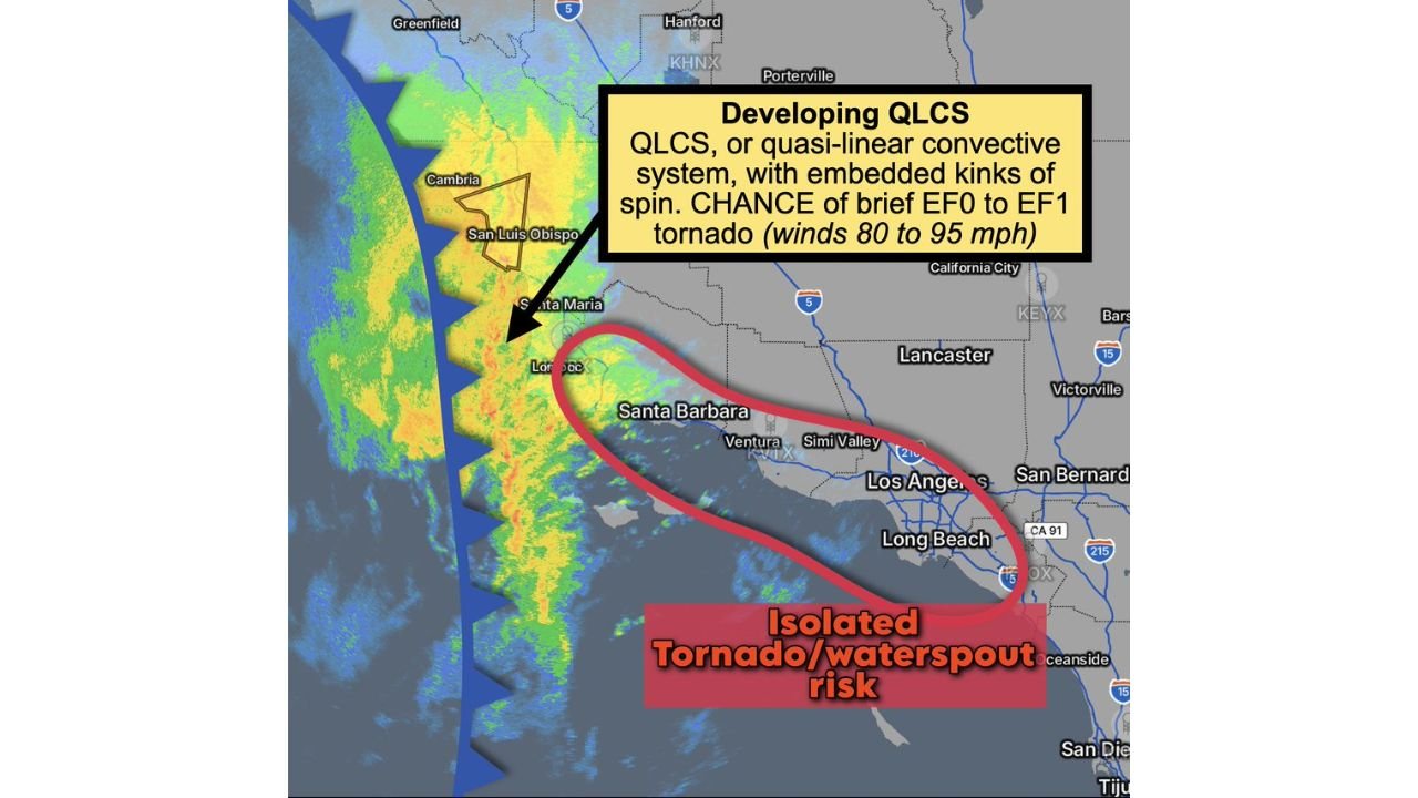
Developing QLCS Approaches Los Angeles From the West With 45–55 MPH Winds and Brief EF0–EF1 Tornado Risk Along the Southern California Coast
SOUTHERN CALIFORNIA — A developing quasi-linear convective system (QLCS) is advancing toward the Central and Southern California coastline, placing areas from San Luis Obispo and Santa Barbara to Ventura, Los Angeles and Long Beach under a risk for strong winds and a brief isolated tornado or waterspout.
The line of thunderstorms is approaching from the west over the Pacific, with embedded kinks suggesting localized rotation within the broader squall line.
Line of Thunderstorms Moving Toward the Coast
Radar imagery shows a consolidated band of heavy showers and thunderstorms stretching southward just offshore of San Luis Obispo and Santa Maria, extending toward the waters west of Santa Barbara and Ventura.
This line is characteristic of a QLCS — a fast-moving band of storms capable of producing straight-line wind gusts of 45 to 55 mph. These winds can cause downed tree limbs, localized power outages and hazardous driving conditions, especially along coastal highways.
As the system pushes inland, the strongest wind potential will likely accompany the leading edge of the line.
Brief EF0 to EF1 Tornado Risk
Embedded within the QLCS are small-scale circulations, or “kinks,” that can spin up short-lived tornadoes. Forecast guidance indicates the possibility of a brief EF0 to EF1 tornado, with potential wind speeds between 80 and 95 mph.
The highest concern appears along the coastal corridor from Santa Barbara through Ventura and into the Los Angeles Basin, including areas near Long Beach.
While tornadoes in Southern California are typically brief and weak compared to those in the central United States, they can still cause localized structural damage and dangerous flying debris.
Waterspout Potential for Offshore Mariners
With the strongest convection remaining partially offshore during approach, there is also a waterspout risk over coastal waters. Mariners west of Santa Barbara, Ventura and Los Angeles should be alert for rapidly changing conditions, gusty winds and isolated rotating cells embedded within the line.
Any waterspouts that form offshore could briefly transition inland if the circulation survives landfall, particularly along immediate coastal communities.
What Residents Should Expect
As the line moves inland, residents can expect periods of heavy rainfall, gusty winds and occasional lightning. The primary threat remains strong straight-line winds, but isolated rotation cannot be ruled out.
Conditions will likely deteriorate quickly as the leading edge arrives, then improve relatively fast once the line passes.
Southern California is not as accustomed to organized QLCS structures as regions farther east, which makes vigilance especially important when these setups develop.
If you observe strong winds, rotating clouds or rapidly intensifying storms as this system moves through Los Angeles, Ventura or Santa Barbara Counties, share your conditions with us at CabarrusWeekly.com. Your reports help track evolving weather threats in real time.