Don’t Store the Snow Shovels Yet: Northern U.S. From Washington to Maine Faces Renewed 3+ Inch Snow Threat Into Mid-March
UNITED STATES — Just as much of the country flirts with springlike warmth, winter is not finished across the northern tier of states.
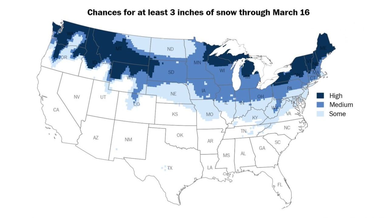
New forecast data through March 16 shows widespread chances for at least 3 inches of snow stretching from the Pacific Northwest across the northern Rockies, through the Upper Midwest, and into the Great Lakes and Northeast. A potential storm next weekend is one to watch closely.
High Snow Chances in the Northern Rockies and Northern New England
The highest probabilities for 3+ inches of accumulation are concentrated across:
- Washington
- Northern Idaho
- Western and central Montana
- Northern Wyoming
- Northern Maine
These areas are shaded in the highest category, indicating strong confidence in measurable snowfall exceeding three inches during the next several days.
In the Northeast, much of Maine stands out as a prime target for accumulating snow, reinforcing that winter conditions remain locked in across far northern New England.
Medium Chances Across the Upper Midwest and Great Lakes
A broad swath of medium snow probabilities extends across:
- North Dakota
- South Dakota
- Minnesota
- Wisconsin
- Northern Michigan
- Northern Pennsylvania
- Upstate New York
Cities across this corridor could see accumulating snowfall as systems track through the northern Plains and Great Lakes region.
This setup suggests active storm tracks riding along the U.S.-Canada border — a classic late-winter pattern.
Some Accumulation Possible Farther South
Lower, but still notable, probabilities extend into:
- Nebraska
- Iowa
- Northern Illinois
- Indiana
- Ohio
- Portions of Kentucky
- Western Virginia and West Virginia
- Parts of Colorado
While amounts may be more limited in these regions, at least some accumulating snow remains possible — particularly if storm tracks shift slightly south.
Weekend Storm Worth Monitoring
Forecasters are highlighting a potential system next weekend that could bring a more organized round of snowfall somewhere across the northern U.S.
The exact track and intensity remain uncertain this far out, but the pattern favors continued storm development along the northern tier.
Even as early-spring warmth dominates parts of the South and East, the northern states remain positioned along the battleground between cold Canadian air and incoming storm systems.
A Tale of Two Seasons
The contrast across the country is striking:
- The South and Southeast are experiencing temperatures in the 70s and 80s.
- The northern Rockies, Upper Midwest, and New England are still tracking measurable snowfall chances.
This sharp north-south divide is typical of March, when winter and spring often collide across the United States.
Bottom Line
Don’t put away the snow shovels just yet if you live from Washington and Montana through Minnesota, the Great Lakes, and into Maine. Many northern states have at least a medium chance — and in some cases a high chance — of seeing more than 3 inches of snow through March 16.
With another possible storm lining up next weekend, winter may have one more act left before true spring fully takes hold.
CabarrusWeekly.com will continue monitoring updates as the forecast evolves.