Early-Summer Humidity Surges Into Miami as Above-Normal Heat Expands North Across the Eastern United States
FLORIDA — It felt more like late May than early March in Miami, where early-summer warmth and thick humidity returned in force, signaling the beginning of a broader warm surge that is forecast to expand northward across much of the Eastern United States this week.
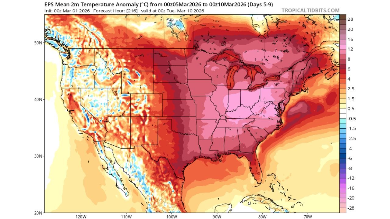
Temperature Anomalies Show Widespread Above-Normal Heat
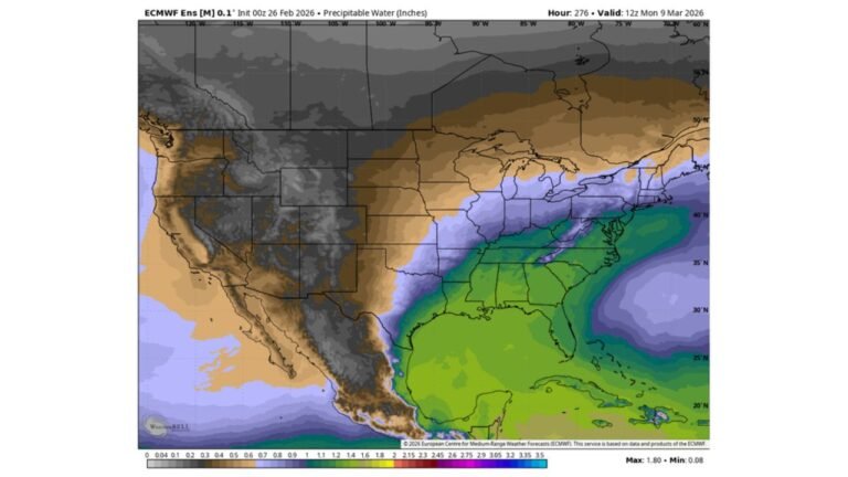
Medium-range ensemble guidance valid March 5–10 shows a large swath of the country running well above seasonal averages. The strongest positive temperature anomalies stretch from South Florida through the Gulf Coast, Tennessee Valley, Mid-Atlantic, and into the Northeast.
The anomaly map indicates much of the Eastern U.S. experiencing temperatures several degrees above normal, with the Deep South and Southeast firmly embedded in warmer-than-average air.
This pattern supports sustained warmth across:
- Florida
- Georgia and Alabama
- The Carolinas
- The Ohio Valley
- The Mid-Atlantic and Northeast
Miami’s Humidity Surge Signals Seasonal Transition
In South Florida, the return of persistent humidity marks a notable seasonal shift. Dew points have climbed, and the air mass now resembles early summer rather than late winter.
The developing upper-level pattern favors continued moisture transport from the Gulf and western Atlantic. For South Florida residents, this may mean that the parade of meaningful cold fronts will soon diminish. Historically, once late-season ridging strengthens in March, true cold air intrusions become less frequent.
The current setup suggests that for Miami and surrounding South Florida communities, the window for impactful cold fronts may be narrowing as the region moves closer to its warm-season regime.
Warmth Spreads North Through the Week
As the ridge expands, warmth is forecast to push north across the Eastern U.S. This includes:
- The Carolinas and Virginia experiencing springlike afternoons
- The Midwest and Great Lakes trending milder than average
- The Northeast seeing temperatures above early-March norms
While exact daily highs will vary, the overall signal supports a broad, multi-day stretch of above-normal readings across much of the eastern half of the country.
Pattern Change Possible Later in March
Although the current configuration favors warmth, longer-term signals suggest that additional pattern adjustments could occur later in March. Upper-level ridging can fluctuate, and late-season troughs are still possible before the calendar fully transitions into spring.
However, for South Florida specifically, the atmospheric setup indicates it may not be long before cold fronts lose their seasonal strength, with sustained warmth becoming more dominant through spring and summer.
What This Means for the Deep South and East Coast
Residents across the eastern U.S. should prepare for a stretch of warmer, more humid conditions, especially in the Southeast. Early pollen surges, increasing humidity levels, and rising overnight temperatures may accompany the warming trend.
In South Florida, the early-summer feel may persist, reinforcing the region’s transition toward its typical warm-season pattern.
If you are experiencing unusually warm or humid conditions in your area, share your observations with us at CabarrusWeekly.com as we continue tracking this expanding warm pattern across the East.