East Coast Winter Storm Signals Major to Extreme Impacts Across North Carolina as Dangerous Travel and Widespread Disruptions Loom
UNITED STATES — A strengthening East Coast winter storm is setting up for significant to potentially extreme impacts across a large portion of North Carolina this weekend, with dangerous travel conditions, major disruptions to daily life, and possible power outages expected as the system intensifies.
North Carolina at the Center of the Highest Impact Zone
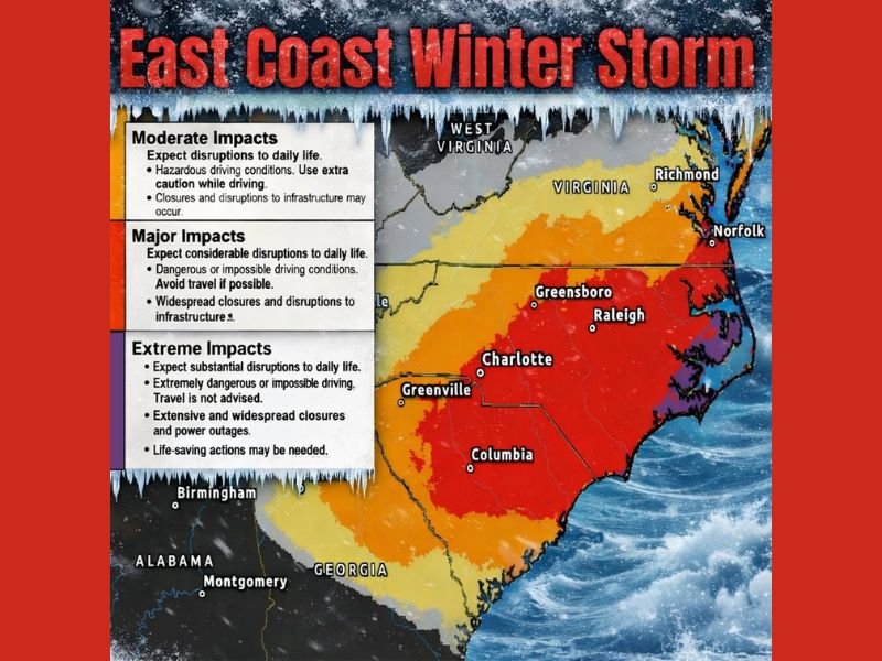
Updated winter impact guidance places much of North Carolina in the “Major” to “Extreme” impact categories, the highest levels shown on the map. The most severe impacts are focused across central and eastern North Carolina, including areas around Charlotte, Greensboro, Raleigh, and extending toward the coastal plain.
The deepest purple shading—indicating Extreme impacts—marks locations where travel may become impossible, and where life-saving actions could be required if conditions deteriorate rapidly.
What “Extreme Impacts” Mean on the Ground
Areas under the extreme category should prepare for substantial disruptions to daily life. Forecast impacts include extremely dangerous or impossible driving conditions, extensive road closures, and a heightened risk for widespread power outages.
Emergency officials typically advise avoiding all non-essential travel in these zones, as emergency response times may be delayed during the height of the storm.
Major Impacts Stretch Into Virginia and South Carolina
Surrounding states are also expected to feel the effects. Major impact zones extend northward into Virginia and southward into parts of South Carolina, including areas near Columbia and Greenville. These regions may experience dangerous driving conditions, widespread infrastructure disruptions, and prolonged travel issues.
Farther west and south, including portions of Georgia and Alabama, impacts decrease but still include moderate disruptions, especially where snow or mixed precipitation overlaps with cold temperatures.
Moderate Impact Areas Still Face Hazardous Conditions
Even locations categorized under Moderate impacts should not take this storm lightly. These areas can expect hazardous driving, delays, and potential closures, especially during peak snowfall or overnight freezing conditions.
The sharp gradient between moderate, major, and extreme zones highlights how small changes in storm track or intensity could shift the highest-impact areas.
Why This Storm Is Drawing Heightened Concern
The combination of heavy snow, strong winds, and prolonged cold increases the likelihood that impacts will last well beyond the storm itself. Snow-covered roads may remain hazardous for days, and power restoration could take longer in areas experiencing extreme conditions.
Forecasters emphasize that this is not a routine winter event, particularly for parts of the Carolinas that rarely experience storms of this magnitude.
Residents across North Carolina and neighboring states are urged to finalize preparations, limit travel plans, and monitor updates closely. If conditions worsen in your area, share what you’re experiencing and stay informed with continuing winter weather coverage at CabarrusWeekly.com.