Eastern Massachusetts, Rhode Island, and Southern New Hampshire Braced for Final Burst of Heavy Snow Before Dry Slot Moves In
EASTERN MASSACHUSETTS — A powerful winter storm continues to impact Southern New England early Monday, with forecasters warning that another 5 to 6 hours of heavy snow remain possible across parts of eastern Massachusetts, Rhode Island, and southern New Hampshire before a pronounced dry slot temporarily shuts snowfall down later this morning.
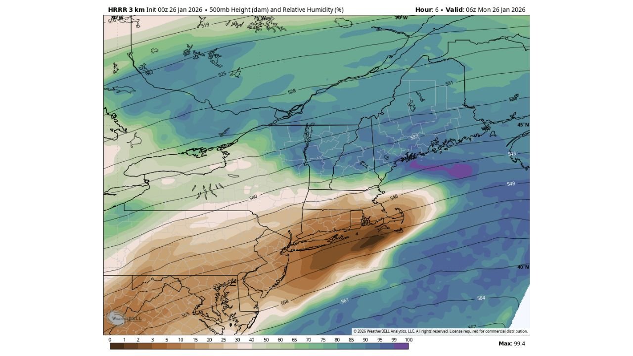
High-resolution HRRR model data valid around 6 a.m. Monday shows deep atmospheric saturation near the 500mb level, supporting intense snowfall rates across eastern sections of the region. Meteorologists say where snow bands persist, an additional 5 to 10 inches of accumulation is possible before conditions briefly ease.
Snowfall Bands Still Delivering Heavy Totals
The latest guidance indicates encouraging conditions for continued snowfall, particularly where mesoscale banding sets up. Areas already under persistent bands overnight are at the highest risk for extreme totals.
Some communities across eastern Massachusetts have already reported significant snowfall, and totals could continue to climb rapidly through mid-morning. Forecasters caution that even small shifts in band placement could mean large differences in accumulation over short distances.
Dry Slot Expected Later This Morning
As the storm evolves, a dry slot is expected to punch northward later this morning, temporarily reducing snowfall rates or stopping snow altogether in some locations. While this may offer a brief break, it does not signal the end of the storm.
Road conditions are expected to remain hazardous due to compacted snow, low visibility, and lingering blowing snow, especially along untreated roadways and secondary routes.
Back-End Snow Possible Monday Afternoon
Meteorologists are closely monitoring the storm’s backside, as atmospheric re-saturation near the 500mb level could allow snow to redevelop Monday afternoon and evening. While this phase is expected to be lighter than the main burst, it could still add additional accumulations and complicate cleanup efforts.
Travel disruptions may continue into the afternoon commute if snow redevelops over already snow-covered roads.
What Residents Should Expect Next
Officials urge residents across eastern Massachusetts, Rhode Island, and southern New Hampshire to remain cautious, avoid unnecessary travel, and prepare for rapidly changing conditions through the day.
Snowfall totals will depend heavily on band placement, but the potential remains for major storm totals before the system finally pulls away late Monday.
CabarrusWeekly will continue tracking this evolving winter storm and provide updates as conditions change. Share your local snowfall totals and storm impacts, and stay connected with CabarrusWeekly for the latest regional weather coverage.