Eastern U.S. Braces for Early-Week Cold Surge as GEFS HDD Spike Builds, While Western States Run 10–20° Above Normal
UNITED STATES — A sharp east–west weather divide is taking shape across the country, with new ensemble guidance pointing to a brief but notable cold surge across the Eastern U.S. early next week, while much of the West turns significantly warmer than normal. The latest GEFS Heating Degree Day (HDD) trends show a rebound in demand just as February begins to wind down.
Eastern U.S. Turns Colder Than Normal Early Next Week
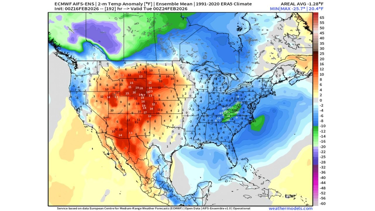
The latest ECMWF ensemble temperature anomaly map valid Tuesday, February 24 highlights widespread below-normal temperatures from the Deep South through the Mid-Atlantic and into the Northeast.
Colder-than-average conditions are projected across:
- Tennessee Valley
- Carolinas
- Georgia and Alabama
- Ohio Valley
- Mid-Atlantic states
- Northeast corridor
Blue shading dominates much of the eastern half of the country, signaling several degrees below seasonal averages. Inland sections appear colder than coastal areas, suggesting a stronger core of chilly air settling over interior regions.
This setup supports rising heating demand across major population centers from Atlanta to Washington, D.C., Philadelphia, and New York City.
Western U.S. Warms 10–20 Degrees Above Average
In stark contrast, the western half of the nation is forecast to run well above normal.
The ensemble map shows deep oranges and reds across:
- California
- Nevada
- Arizona
- Utah
- Colorado
- Wyoming
- Montana
- Parts of the Northern Plains
Some areas across the Rockies and Interior West are projected to run 10 to 20 degrees above seasonal averages, driven by a strong upper-level ridge dominating the region.
This creates a classic late-winter temperature split — troughing in the East, ridging in the West.
GEFS HDD Trends Signal Energy Demand Spike
The GEFS GASHDD run trends versus normals chart shows a clear mid-period dip around February 17–18, followed by a sharp upward swing heading into February 21–23.
Key signals from the trend chart:
- A pronounced trough in HDD values mid-period
- Rapid rebound above previous runs
- A short-lived peak near or slightly above the 10-year normal line
- Gradual easing toward month’s end
Weekend model data shifted noticeably toward a stronger early-week HDD spike, confirming colder risks across the eastern half of the country.
Heating Degree Days (HDDs) rise when temperatures drop below average — meaning this surge directly translates into higher heating demand.
Pattern Setup Driving the Divide
The broader atmospheric pattern supports:
- Upper-level troughing across the Eastern U.S.
- Strong ridging over the Western U.S.
- Cold air draining southward into the Southeast and Mid-Atlantic
- Warmer Pacific influence into the Rockies and West Coast
The cold appears impactful but not prolonged. Guidance does not currently show a sustained Arctic outbreak — rather a sharp reminder that winter is not finished yet.
What Happens After the Spike?
The 10-year normal HDD trend line continues to gradually decline as seasonal transition toward spring begins. However, this early-week surge temporarily interrupts that downward slide.
After the spike peaks around February 22–23, ensemble guidance suggests moderation returning toward late February.
Still, this setup reinforces that meaningful late-winter swings remain possible before the calendar flips to March.
Cabarrus Weekly will continue monitoring ensemble shifts and regional impacts as updated model runs refine the magnitude and duration of this early-week cold surge.
Stay with CabarrusWeekly.com for the latest national pattern breakdowns and forecast updates as winter makes one more push before spring.