ECMWF Signals Wetter-Than-Normal Pattern for North Carolina as Late February Storm Track Shifts East, Bringing Ups and Downs Into Early March
NORTH CAROLINA — A shifting late-February weather pattern is setting the stage for a wetter-than-normal stretch across North Carolina, as storm systems push east and cooler air filters into the region heading into early March.
ECMWF Data Shows Above-Normal Precipitation for the Eastern U.S.
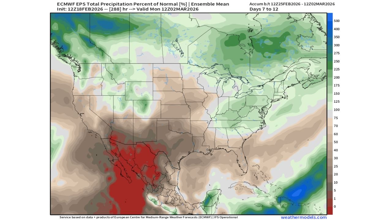
The latest ECMWF ensemble precipitation outlook for February 25 through March 2 indicates a noticeable eastward shift in moisture compared to the western half of the country. According to the model guidance , much of the Southeast and Mid-Atlantic — including North Carolina — is projected to see precipitation totals above seasonal averages.
While the Southwest, including parts of California and northern Mexico, shows well-below-normal precipitation in deep red shading, the eastern half of the United States trends greener on the anomaly map. That green shading signals 100–150% of normal rainfall, with localized pockets potentially exceeding that threshold.
For Cabarrus County and surrounding communities, that translates to increased rain chances and periodic storm systems rather than extended dry spells.
Storm Track Favors the Carolinas
The data suggests a more active southern and eastern storm track as we close out February. With the Ohio Valley and eastern states positioned near the boundary between cooler air to the north and milder Gulf moisture to the south, the Carolinas sit in a corridor favorable for repeated precipitation events.
This setup does not necessarily indicate a single major storm, but rather a pattern of “ups and downs” — alternating periods of mild, moist air followed by cooler pushes behind passing systems.
As cooler air accompanies incoming moisture, there could be brief temperature swings, especially following frontal passages. However, at this time, there is no clear signal for prolonged Arctic outbreaks in North Carolina during this specific window.
Cooler Air Mixing With Moisture Increases Storm Potential
One notable detail in the forecast discussion accompanying the model data is the mention of cooler air moving into the East alongside improved moisture transport. When these two ingredients overlap, it raises the potential for periodic thunderstorm activity, particularly during stronger frontal passages.
For North Carolina, that means residents should be prepared for:
Intermittent rainfall events
Occasional embedded thunderstorms
Temperature fluctuations following cold fronts
While severe weather signals are not explicitly shown in the precipitation anomaly map, any time enhanced moisture and temperature contrasts align, it bears watching as we transition toward the more active spring season.
Southwest Remains Drier While East Turns Active
A stark contrast exists between the eastern and southwestern United States in this outlook. The deep red shading across northern Mexico and portions of the Southwest highlights significantly below-normal precipitation, while the Carolinas and broader eastern region trend toward wetter conditions.
This east-west divide reinforces confidence in a storm track favoring the Southeast and Mid-Atlantic, supporting the idea that North Carolina will remain in the more active side of the pattern.
For Cabarrus County, this means soil moisture levels could gradually improve, and any lingering winter dryness may ease as we approach March.
What This Means for Cabarrus County
For residents in Concord, Kannapolis, Harrisburg, and surrounding communities, the key takeaway is a more unsettled weather pattern through early March. Expect multiple opportunities for rainfall rather than a prolonged stretch of sunny, quiet days.
Timing specifics will continue to be refined, but confidence is increasing that above-normal precipitation is likely during the February 25–March 2 timeframe.
As always, rainfall distribution can vary significantly from one system to the next, so localized totals may differ.
If you’re noticing changing conditions in your area or have rain totals to report, share your observations with us. Stay updated with the latest forecasts and local weather insights at CabarrusWeekly.com.