EF2+ Tornado Risk Expands from Northeastern Missouri Through Northern Illinois into Northwest Indiana Tuesday as SPC Adds 10% Hatched Zone Along Warm Front
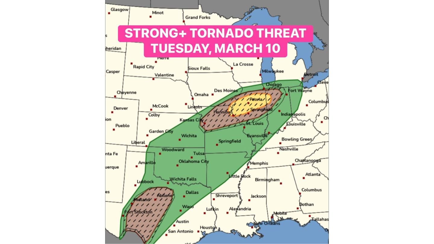
INDIANA — The Storm Prediction Center has upgraded concerns for Tuesday, March 10, adding a 10% hatched tornado area highlighting the potential for EF2 or stronger tornadoes along the warm frontal zone from northeastern Missouri across northern Illinois into northwest Indiana.
This upgrade signals growing confidence that at least a few strong tornadoes could develop in a corridor stretching from near Hannibal and northeastern Missouri, through Peoria and Springfield, Illinois, toward the Chicago metro area and into Fort Wayne, Indiana.
Warm Front Becomes the Focal Point
The enhanced tornado zone is aligned along a warm front expected to lift across northern Illinois Tuesday afternoon and evening.
Communities near and just south of that boundary — including:
- Hannibal, MO
- Peoria, IL
- Springfield, IL
- Chicago, IL
- Fort Wayne, IN
— will be in a zone where wind shear and instability overlap most favorably.
Forecasters are particularly concerned about supercells forming along the front during the late afternoon and evening hours.
Why the Hatched Area Matters
A 10% hatched tornado risk specifically denotes the potential for:
- EF2+ tornadoes
- Longer-track or stronger tornadoes
- Greater potential for significant damage
The hatched designation is reserved for setups where atmospheric parameters support stronger tornado potential rather than brief, weak spin-ups.
Widespread Severe Weather Expected
Beyond the tornado threat in the Midwest corridor, a broader severe weather outbreak is expected March 10–11 across a much larger swath of the country.
The overall severe risk extends southwest from:
- Northern Illinois and Indiana
- Through Missouri
- Into Oklahoma
- And down into West Texas
This includes cities such as:
- Kansas City, MO
- Tulsa, OK
- Oklahoma City, OK
- Wichita Falls, TX
- Abilene, TX
- Midland, TX
Secondary Severe Mode in West Texas
Another round of severe storms is possible Tuesday evening and overnight off the dryline in West Texas as the upper-level trough ejects.
Those storms could also organize into supercells, producing:
- Large hail
- Damaging winds
- Additional tornadoes
While the Midwest corridor carries the stronger tornado signal along the warm front, the southern Plains could see a separate but impactful severe event.
Timing: Tuesday Afternoon Through Night
The primary tornado window across northeastern Missouri, northern Illinois, and northwest Indiana appears focused on:
- Late Tuesday afternoon
- Early to mid-evening
Storms may continue into the overnight hours farther south and west.
Because much of the tornado risk is tied closely to the warm front position, even minor shifts north or south could significantly alter which cities experience the greatest threat.
Another Widespread Outbreak Setup
This system represents another multi-state severe weather event early in the season, with both Midwest and southern Plains components active.
The addition of the 10% hatched area underscores that Tuesday is not just a routine severe day — but one with potential for strong tornadoes along a defined corridor.
Bottom Line
The Storm Prediction Center has added a 10% hatched tornado risk for EF2+ potential Tuesday from northeastern Missouri through northern Illinois into northwest Indiana. Cities including Hannibal, Peoria, Springfield, Chicago, and Fort Wayne lie within or near the upgraded zone. A separate severe storm mode is also possible in West Texas Tuesday evening.
Residents across the highlighted areas should closely monitor forecast updates and ensure severe weather safety plans are in place ahead of Tuesday’s storms.
CabarrusWeekly.com will continue tracking updates as confidence increases in storm timing and boundary placement.