Egg-Sized Hail Threat Expands from Missouri Through Illinois, Indiana, Ohio into Pennsylvania as Severe Storm Corridor Intensifies
MISSOURI, ILLINOIS, INDIANA, OHIO, PENNSYLVANIA — A dangerous severe weather setup is taking shape today across the Midwest and Ohio Valley, where hailstorms are expected to become widespread, with some areas facing the potential for hail as large as eggs or even larger in isolated cases.
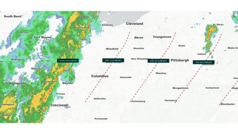
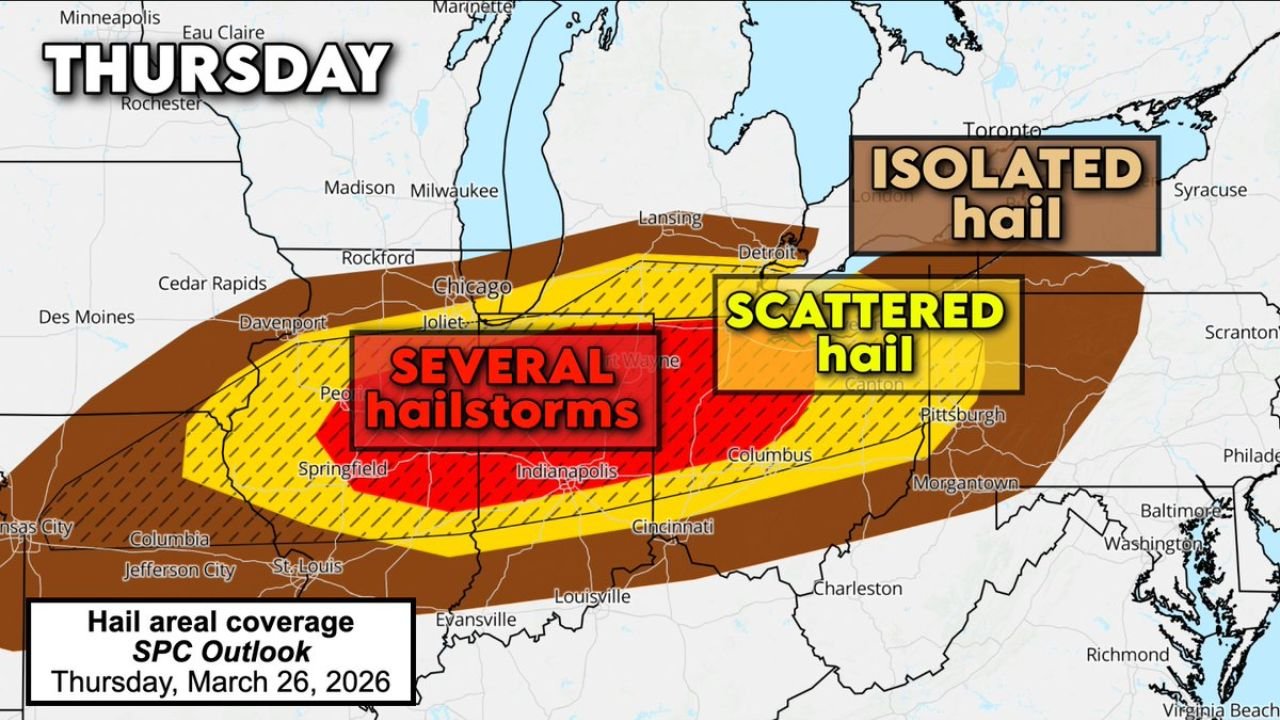
Forecast data shows a well-defined corridor of hail risk stretching from eastern Missouri through Illinois, Indiana, and Ohio into western Pennsylvania, placing millions in the path of potentially damaging storms.
Highest Concentration of Hailstorms Targets Illinois and Indiana
The greatest coverage of hail-producing storms is expected across:
- Central and eastern Illinois
- Much of Indiana
- Western Ohio
This region is highlighted as the core zone for “several hailstorms,” meaning multiple rounds of storms could track over the same areas, increasing the risk of repeated impacts.
Surrounding areas, including parts of Missouri and Pennsylvania, are expected to see scattered to isolated hailstorms, but still with the potential for severe conditions.
Egg-Sized Hail Possible in Strongest Storms
Where storms become fully developed and organized, the atmosphere is capable of producing:
- Egg-sized hail (around 2 inches in diameter)
- Locally larger hail in isolated supercells, potentially approaching baseball size
It’s important to note that while the largest hail will not occur everywhere, any storm that intensifies could quickly become capable of producing significant damage to vehicles, roofs, and crops.
Why This Setup Is So Dangerous
This event is being driven by a classic severe weather pattern:
- A strong atmospheric boundary helping storms organize
- Warm, unstable air fueling rapid storm growth
- Conditions supportive of rotating thunderstorms (supercells)
These ingredients allow storms to sustain powerful updrafts, which is the key factor in producing very large hailstones.
Storm Timing Through the Day
The severe weather threat will evolve throughout the day:
- Midday to early afternoon: Initial storm development begins, especially across Missouri and Illinois
- Late afternoon: Storms intensify and expand into Indiana and Ohio
- Evening into night: Severe storms continue into Pennsylvania, with lingering hail and heavy rain
Because storms may form in clusters, some locations could experience multiple rounds of severe weather in just a few hours.
Damaging Winds and Tornado Risk Still Present
While hail is the primary concern, storms may also bring:
- Damaging wind gusts capable of causing power outages
- A few tornadoes, especially in stronger rotating cells
This combination makes today’s setup multi-hazard, requiring close attention across all impacted states.
Residents Urged to Stay Alert
With several hailstorms expected and the potential for large, damaging hail, residents across the Midwest and Ohio Valley should prepare now.
Have multiple ways to receive warnings, move vehicles to shelter if possible, and be ready to act quickly as storms develop.
Stay with CabarrusWeekly.com for continued updates as this severe weather event unfolds across Missouri, Illinois, Indiana, Ohio, and Pennsylvania.