Euro Model Shifts Nor’easter Closer to Coast With Heavy Snow Signal from New Jersey to Southern New England
UNITED STATES — A significant shift in the latest 06Z Euro-AI ensemble guidance is bringing a potential late-February nor’easter closer to the East Coast, increasing the snowfall signal from the Mid-Atlantic through southern New England.
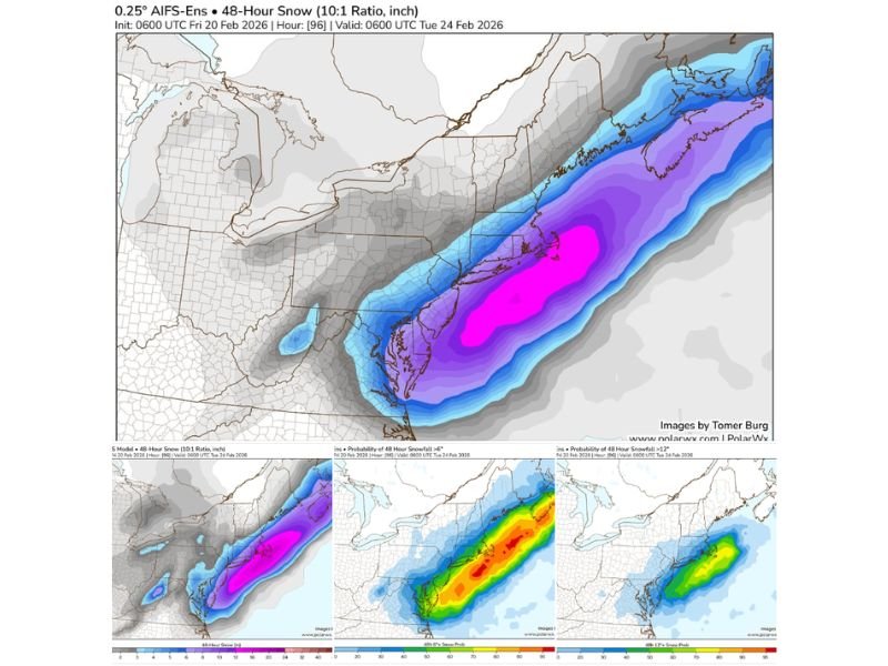
New ensemble data valid through early Tuesday, February 24, 2026, shows a more consolidated and coastal-focused snow band compared to previous runs. The updated guidance includes both projected snowfall totals and probabilities for at least 6 inches and at least 12 inches of accumulation.
Heaviest Snow Band Targets Coastal Mid-Atlantic and Southern New England
The 48-hour snowfall projection (10:1 ratio) highlights the most intense snow band extending from:
- Coastal New Jersey
- Eastern Pennsylvania
- Long Island
- Connecticut
- Rhode Island
- Eastern Massachusetts
The deepest purple shading offshore and along portions of the coastal plain suggests the potential for significant accumulation if the storm tracks as currently projected.
Inland areas across upstate New York, western Pennsylvania, and interior New England remain in lighter gray to blue shading, indicating lower projected totals compared to the coastal corridor.
High Probabilities for 6+ Inches Along I-95 Corridor
Ensemble probability maps show a strong signal for at least 6 inches of snowfall along much of the I-95 corridor from the northern Mid-Atlantic into southern New England.
The highest probabilities appear concentrated from:
- Southern New Jersey
- Long Island
- Coastal Connecticut
- Rhode Island
- Eastern Massachusetts
These areas show enhanced ensemble agreement, meaning multiple model members are aligning on a heavier snow solution.
12+ Inch Potential Emerging in Core Coastal Zone
The probability map for at least 12 inches of snowfall reveals a narrower but notable corridor of elevated risk.
This higher-end snow potential is centered offshore and along parts of:
- Coastal New Jersey
- Long Island
- Coastal southern New England
While probabilities are lower than the 6-inch threshold, the signal has strengthened compared to prior model runs, indicating growing confidence in a heavier snow axis if the coastal track holds.
What the Shift Means
The key takeaway from the latest ensemble update is the “closer-to-coast” adjustment. A slight westward nudge in storm track can dramatically increase snowfall totals along densely populated coastal areas.
If the storm remains offshore, totals would be lighter. However, the latest guidance suggests a tighter gradient setting up closer to land, increasing the risk for impactful snowfall along major population centers.
The storm remains several days out, and track adjustments are still possible. Small shifts of 50–100 miles could significantly change snowfall distribution.
Why This Matters for North Carolina Readers
While the primary snow threat is focused from New Jersey northward, nor’easter systems can influence broader East Coast weather patterns. Strong coastal systems often bring gusty winds and colder air southward behind them.
Cabarrus County and much of North Carolina are not currently in the heavy snow axis shown in the latest guidance. However, this evolving pattern reinforces an active late-winter setup along the East Coast.
Forecast confidence will increase as the event approaches and higher-resolution models come into range. Cabarrus Weekly will continue monitoring model trends and provide updates as new guidance becomes available.