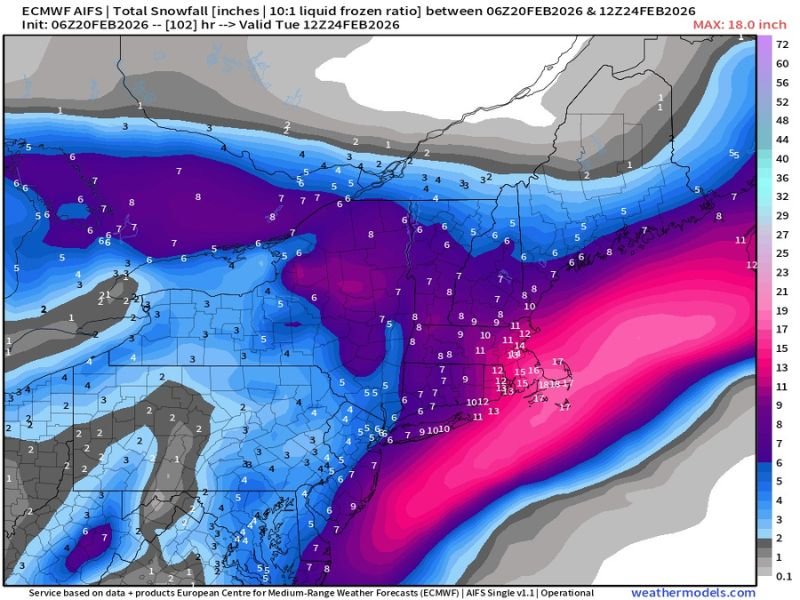
Euro Model Shows Widespread 6–12+ Inch Snow Potential From Midwest to Northeast as Two Storms Merge
UNITED STATES — The latest 06Z Euro-AI operational model run is depicting a broad and impactful late-winter snowfall event stretching from the central Plains through the Midwest and into the Northeast as two storm systems combine over several days.
It’s important to emphasize that this is a single model solution — not an official forecast — but the latest guidance shows a significant and organized snow swath developing between February 20 and February 24, 2026.
Midwest and Great Lakes in the Core Snow Band
The model projects a widespread corridor of 6 to 8 inches of snow across portions of:
- Northern Missouri
- Iowa
- Illinois
- Indiana
- Southern Michigan
- Northern Ohio
Within this zone, several areas in Illinois, Indiana, and southern Michigan show localized totals pushing toward or slightly above 8 inches. Northern Michigan and parts of Wisconsin are projected to see lighter amounts, generally in the 3–6 inch range.
The snow field appears relatively consistent across the Midwest, indicating both storm systems contribute to cumulative totals rather than a single quick-hitting event.
Ohio Valley Into Pennsylvania and New York
Farther east, the Ohio Valley remains solidly in the accumulating snow zone. Portions of:
- Kentucky
- West Virginia
- Central and eastern Ohio
are shown with projected totals in the 5–8 inch range.
Across Pennsylvania and upstate New York, a broad 4–7 inch swath is indicated, with some higher pockets near the New York–Pennsylvania border.
Northern New England, including parts of northern Maine and far northern Vermont, shows lighter projections generally between 1 and 4 inches.
Coastal Northeast Shows Higher-End Potential
The most striking feature of the map is the sharp snowfall gradient near the East Coast.
From:
- New Jersey
- Long Island
- Southern Connecticut
- Rhode Island
- Eastern Massachusetts
the model indicates a significantly heavier band of snowfall, with double-digit totals possible in parts of the coastal plain.
Some localized areas show projections exceeding 12 inches, and peak values on the map approach 18 inches in the most favored coastal corridor. This suggests a storm track close enough to the shoreline to enhance snowfall in densely populated metro areas.
However, this coastal axis is highly sensitive to track changes. Even a modest east or west shift could dramatically alter who sees the highest totals.
Forecast Still Subject to Change
Because this is one operational model run, snowfall amounts and placement will likely fluctuate in coming updates. Ensemble guidance and additional model cycles will help refine confidence in both totals and storm track. With two systems interacting, subtle changes in timing and positioning could significantly impact final accumulations. Forecasters will continue monitoring trends closely as the event approaches.