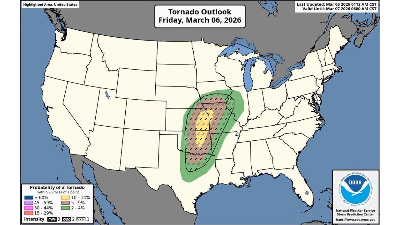
Expansive Tornado Risk Spreads From Texas Through Oklahoma, Kansas, Missouri and Into Illinois on Friday With Potential for Strong Tornadoes
UNITED STATES — A broad and potentially dangerous tornado setup is expected to unfold Friday, March 6, stretching from Texas northward through Oklahoma, eastern Kansas, western Missouri and into Illinois.
The latest Tornado Outlook highlights an expansive corridor where rotating storms may develop during the afternoon and evening hours, bringing the risk of tornadoes, damaging winds and large hail.
Where the Tornado Risk Is Highest
The most favorable environment for tornado development appears centered across:
- Eastern Oklahoma
- Eastern Kansas
- Western Missouri
This corridor sits within a higher tornado probability zone, including hatched areas that indicate the potential for stronger tornadoes if storms remain discrete and organized.
Surrounding areas under tornado risk include:
- Much of Oklahoma
- Northern and central Texas
- Western and central Arkansas
- Southern and central Missouri
- Parts of Illinois
The risk zone forms a long, north-south corridor from the Southern Plains into the Mid-Mississippi Valley.
Timing: Afternoon Into Evening
Storms are expected to develop during the afternoon hours Friday, intensifying into the evening as they track northeast.
If supercells are able to remain isolated ahead of any developing storm line, the environment would support:
- A few tornadoes
- Potentially a couple of strong tornadoes
- Large hail
- Damaging straight-line winds
However, one key uncertainty is early-day convection. If morning storms are widespread, they could limit instability and reduce overall storm intensity in some areas.
Why This Setup Is Concerning
This event stands out because:
- The tornado risk covers multiple states from Texas to Illinois
- Atmospheric wind shear appears strong across the corridor
- Moisture return from the Gulf is expected to feed storms across the Plains
The overlap of instability and wind shear across eastern Oklahoma, eastern Kansas and western Missouri is particularly noteworthy.
States Most Impacted
Communities in the following states should closely monitor updates:
- Texas
- Oklahoma
- Kansas
- Missouri
- Arkansas
- Illinois
While not every location within the outlined zone will see severe weather, conditions are supportive of storms capable of producing tornadoes.
Stay Weather Aware
With a growing severe signal and a large geographic area involved, Friday has the potential to become a significant severe weather day across parts of the Central U.S.
Residents in the highlighted states should:
- Review severe weather safety plans
- Ensure multiple ways to receive warnings
- Monitor forecast updates throughout the day
CabarrusWeekly.com will continue tracking this developing tornado threat and provide updates as timing and storm details become clearer.