Explosive “Bomb Cyclone” Strengthens Offshore with 973 mb Pressure as Shapiro-Keyser Structure Signals Intensifying Northeast Blizzard
WESTERN ATLANTIC OCEAN — A rapidly intensifying coastal low has evolved into a classic bomb cyclone, deepening to around 973 mb just offshore of the Mid-Atlantic and Northeast, and forecasters say its structure follows the powerful Shapiro-Keyser cyclone model — a setup often associated with strengthening winds and heavy snow.
Latest model data shows the storm wrapping up east of the Delmarva Peninsula and south of New England, with tight pressure gradients and strong wind fields developing around the circulation center.
What the Shapiro-Keyser Structure Means
Unlike a traditional winter storm, the Shapiro-Keyser model features:
- A warm seclusion near the center
- An evolving shallow warm core
- Potential development of a sting jet
- Intense wraparound snow bands
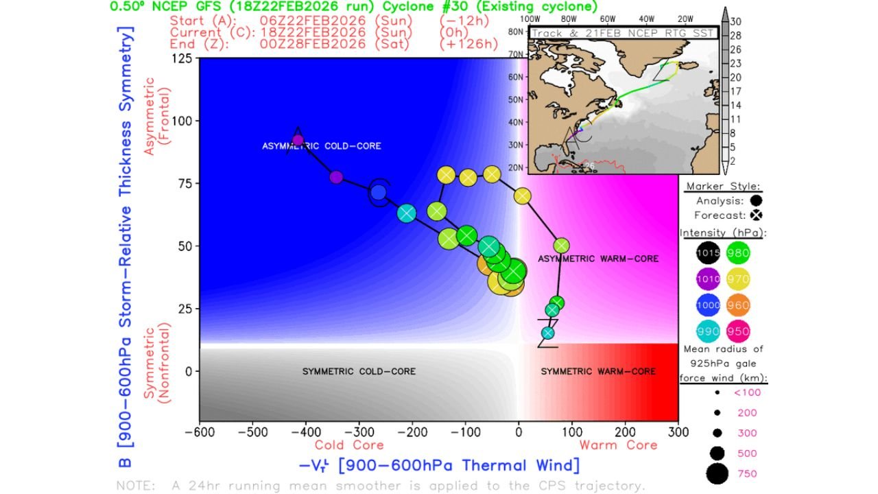
Cyclone phase diagrams indicate the system transitioning from an asymmetric cold-core structure toward a more hybrid profile. That evolution can support stronger wind gusts and enhanced snowfall rates near and northwest of the low center.
Meteorologists highlight this as a storm “to watch gain strength” as it matures offshore.
973 mb Low Spinning East of the Mid-Atlantic
850 hPa temperature and wind analysis shows:
- Strong northerly flow pulling cold air into the Northeast.
- Tight wind packing along the coastal gradient.
- Heaviest dynamics focused offshore but close enough to fuel coastal impacts.
The low center remains positioned east of the Mid-Atlantic coastline, tracking north-northeast while deepening over the Atlantic waters. That offshore placement is critical — it keeps the heaviest snow bands near coastal New Jersey, Long Island, and southern New England while maintaining strong wind potential along the shoreline.
Potential for a Sting Jet
One of the more concerning elements in a Shapiro-Keyser cyclone is the development of a sting jet — a narrow corridor of powerful winds descending from aloft.
If realized, this feature could:
- Produce localized damaging gusts.
- Enhance blowing and drifting snow.
- Intensify coastal impacts even after peak snowfall.
While sting jets are not guaranteed, the structural signals within this storm suggest the environment is supportive.
What This Means for North Carolina
For Cabarrus County and central North Carolina, the storm remains well offshore and north of the region.
Impacts locally are expected to be limited to:
- Cooler air filtering south behind the system.
- Possible breezy conditions as pressure gradients shift.
- No direct snowfall or major disruption anticipated.
However, rapidly deepening coastal systems like this can temporarily alter broader East Coast weather patterns.
A High-Impact Northeast Event
With central pressure near 973 mb and structural signals pointing to continued strengthening, this bomb cyclone remains a significant winter weather event for parts of the Northeast.
Heavy snow bands, strong winds, and potential coastal impacts will continue as the system matures over the Atlantic.
Cabarrus Weekly will continue monitoring the evolution of this storm and any downstream weather shifts that could affect North Carolina.
Stay with CabarrusWeekly.com for continued updates and regional weather coverage.