Extreme Arctic Outbreak Targets Connecticut and New York This Weekend as Wind Chills Plunge to Minus 20 and Minus 30 Degrees
CONNECTICUT AND NEW YORK — A notable arctic air outbreak is expected to move into the region this weekend, bringing dangerously cold temperatures and extreme wind chills that are rarely observed in parts of southern New England and downstate New York.
Forecast guidance suggests that locations such as Danbury and Waterbury, Connecticut, could experience wind chills of -25°F or colder, a level that historically occurs only during the most intense cold events. Meteorologists note that a comparable situation last occurred in January 2004, when Waterbury recorded wind chills near -30°F.
Models have been persistent in signaling that a similar setup may unfold again.
Winds Increase Saturday as Arctic Air Settles In
Timing remains a key factor in this event. Forecast data indicates that winds will ramp up Saturday, with gusts ranging from 35 to 45 mph as the arctic air mass pushes south.
These strengthening winds will significantly worsen cold exposure, especially during the evening and overnight hours. Wind-driven heat loss will accelerate as temperatures fall, creating life-threatening conditions for anyone outdoors without proper protection.
Temperatures Near or Below Zero by Saturday Night
By Saturday night, air temperatures across many interior locations are forecast to fall near or below zero, setting the stage for the most dangerous period of the outbreak.
As the coldest air settles in, wind chills will continue to drop, reaching their lowest values heading into Sunday morning.
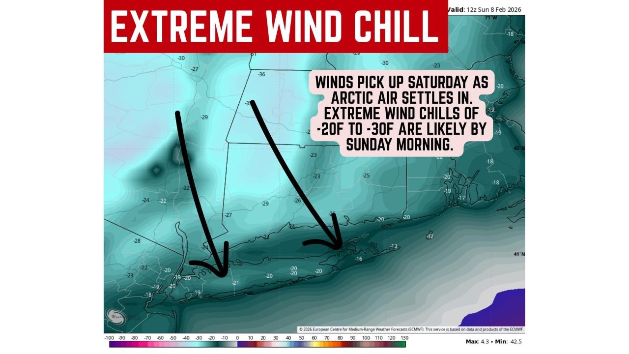
Coldest Wind Chills Expected Sunday Morning
Forecast guidance points to Sunday morning as the peak of the cold, when wind chill values between -20°F and -30°F are considered quite possible across parts of Connecticut, southeastern New York, and nearby interior regions.
These values are well within the range that can cause frostbite in minutes, particularly on exposed skin, and pose serious risks to anyone without adequate heating.
Extreme Cold Warning May Be Required
Due to the severity and rarity of the expected conditions, forecasters caution that a rare Extreme Cold Warning may be needed if confidence in the wind and temperature combination continues to increase.
In addition to health risks, isolated power outages are also a concern, as strong winds and extreme cold can strain electrical infrastructure.
Vulnerable Populations Face Higher Risk
Very cold temperatures disproportionately affect elderly residents, young children, and at-risk populations, especially those with limited access to heat. Officials urge residents to check on neighbors, family members, and anyone who may need assistance during the coldest period.
Residents are encouraged to:
- Limit time outdoors
- Dress in multiple insulating layers
- Protect exposed skin
- Ensure pets are indoors
- Prepare for potential power interruptions
Bottom Line
This weekend’s arctic outbreak is shaping up to be one of the coldest events in years for parts of Connecticut and New York, with dangerous wind chills rivaling historic cold snaps. While final details are still being refined, the signal for extreme cold is strong and persistent.
CabarrusWeekly.com will continue monitoring this developing situation and provide updates as forecasts are refined and official alerts are issued.