Extreme Winter Storm Threatens Texas, Oklahoma, Arkansas, Tennessee, Kentucky, Ohio, Pennsylvania, North Carolina, and the Northeast With Ice, Heavy Snow, and Dangerous Arctic Cold
UNITED STATES — Confidence is increasing that a major to potentially extreme winter storm will impact a large portion of the United States beginning Friday and continuing through the weekend, as a powerful system moves eastward while Arctic air spreads across much of the country. Forecast guidance indicates widespread ice, double-digit snowfall in some regions, and prolonged dangerous cold, with impacts possibly becoming historic in localized areas.
A Broad, High-Impact Winter Setup Is Coming Together
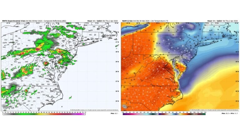
The latest national outlook shows a large, organized storm system interacting with entrenched Arctic air, a combination that supports significant winter weather over multiple days. Unlike quick-moving systems, this pattern allows snow and ice to persist, increasing risks to travel, power infrastructure, and public safety.
Meteorologists note that confidence is high a storm will occur, while exact impact zones are still being refined, particularly along the snow-to-ice transition corridor.
Heavy Snow Corridor From the Southern Plains to the Northeast
A wide swath from North Texas through Arkansas, Tennessee, Kentucky, Ohio, Pennsylvania, and into the Northeast is currently favored for heavy snowfall. Several regions within this zone could see double-digit snow totals, especially where colder air remains deep and precipitation remains steady.
Snowfall is expected to begin as early as Friday, with peak impacts likely Friday night through Saturday, before shifting eastward toward the Mid-Atlantic and New England.
Dangerous Ice Threat Across the Deep South and Southeast
Farther south, a significant freezing rain corridor is developing, stretching from parts of Texas through Arkansas, Mississippi, Alabama, Georgia, South Carolina, and into North Carolina. This region sits beneath shallow surface cold air with warmer air aloft, a classic setup for freezing rain rather than snow.
Even moderate ice accumulation can result in downed trees, widespread power outages, and extremely hazardous road conditions, making this zone one of the highest-risk areas of the storm.
Arctic Cold Expands and Lingers After the Storm
Behind the precipitation shield, dangerous Arctic cold is expected to take over much of the U.S., including portions of the Deep South and Southeast, with some guidance even showing impacts into parts of Florida early next week.
Several regions are forecast to experience multiple consecutive days of below-freezing temperatures, preventing melting and prolonging travel and infrastructure issues. Wind chills in some areas may reach life-threatening levels.
Timeline: When Impacts Are Expected
The first significant impacts are expected to begin Friday, with snow and ice intensifying into Friday night and Saturday. The system then shifts east, bringing continued impacts into Sunday, while Arctic cold lingers well into early next week across many states.
Because this is a multi-day event, impacts may compound over time, particularly in areas dealing with both ice and extreme cold.
Why This Storm Could Be Historic for Some Areas
Forecasters are increasingly concerned due to the combination of storm strength, geographic size, and Arctic air depth. Large areas may face both heavy precipitation and prolonged freezing temperatures, a scenario that has historically led to long-lasting power outages and major disruptions.
While not every location will experience the worst-case scenario, some regions may see impacts rarely observed in recent years.
What Residents Should Do Now
Residents across Texas, Oklahoma, Arkansas, Tennessee, Kentucky, Ohio, Pennsylvania, North Carolina, and neighboring states should begin preparing now, especially for power outages, hazardous travel, and extreme cold exposure. Travel plans this weekend may need adjustment as conditions evolve.
Forecast details will continue to be refined over the next 24 to 48 hours, but the overall signal for a high-impact winter storm is strong. Stay alert for local updates, and share conditions from your area as this system develops at CabarrusWeekly.com.