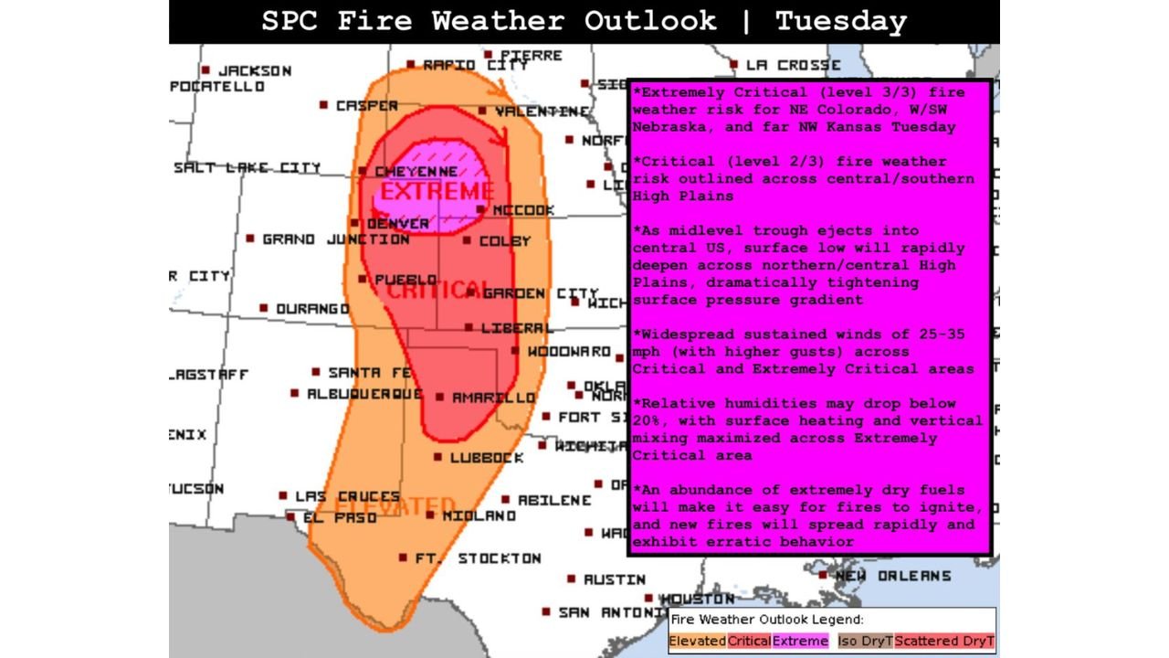
Extremely Critical Fire Weather Erupts Across Northeast Colorado, Western Nebraska and Northwest Kansas as 35 MPH Winds and Sub-20% Humidity Create Explosive Wildfire Risk
NORTHWEST KANSAS — Extremely Critical fire weather conditions are expected Tuesday across portions of the central High Plains, where strong winds, very low humidity and dry fuels will combine to create a volatile wildfire environment.
The highest threat zone centers on northeast Colorado, extending into western and southwest Nebraska and far northwest Kansas, where fire behavior could become rapid and erratic.
Extremely Critical Risk Focused Near the Colorado–Nebraska Border
The core of the Level 3 of 3 “Extremely Critical” designation includes areas near Denver, Cheyenne and extending east toward McCook and Colby. In this zone, atmospheric conditions are aligned for the most aggressive fire spread potential.
A strengthening surface low over the central High Plains will dramatically tighten the pressure gradient, leading to widespread sustained winds of 25 to 35 mph, with higher gusts possible.
When winds of this magnitude combine with very dry fuels, fires can ignite easily and spread quickly before suppression efforts can contain them.
Critical Fire Risk Expands Across the Central and Southern High Plains
Surrounding the extreme core, a broader Critical (Level 2 of 3) fire weather area stretches southward through eastern Colorado into western Kansas and the Texas Panhandle, including communities near Pueblo, Garden City, Liberal, Amarillo and Lubbock.
In these areas, sustained winds in the 25 to 35 mph range will persist, while relative humidity values are forecast to drop below 20 percent during peak afternoon heating.
Such dry air allows fuels — including grasses and dormant vegetation — to ignite readily and support rapid forward fire growth.
Why Conditions Are So Dangerous
As a midlevel trough ejects into the central United States, the associated surface low is expected to deepen across the northern and central High Plains. This setup enhances vertical mixing, drawing stronger winds down to the surface while simultaneously drying the lower atmosphere.
Surface heating will further reduce humidity, particularly across northeast Colorado and adjacent parts of Nebraska and Kansas, maximizing fire spread potential during the afternoon hours.
The presence of abundant extremely dry fuels significantly increases the likelihood that any spark — whether accidental or natural — could lead to a fast-moving wildfire.
Rapid and Erratic Fire Behavior Possible
In the Extremely Critical zone, fire behavior may become erratic, with shifting winds and rapid changes in spread direction. This can complicate firefighting efforts and increase risk to rural communities and roadways.
Residents across the High Plains are urged to avoid activities that could produce sparks, including outdoor burning, welding or parking vehicles on dry grass.
Given the alignment of strong winds, low humidity and dry fuels, Tuesday’s fire weather setup represents one of the more concerning scenarios for late-winter wildfire outbreaks across northeast Colorado, western Nebraska and northwest Kansas.
If you observe smoke plumes or rapidly spreading fires in your area, share updates and safe reports with us at CabarrusWeekly.com. Community observations are critical during high-impact fire weather events.