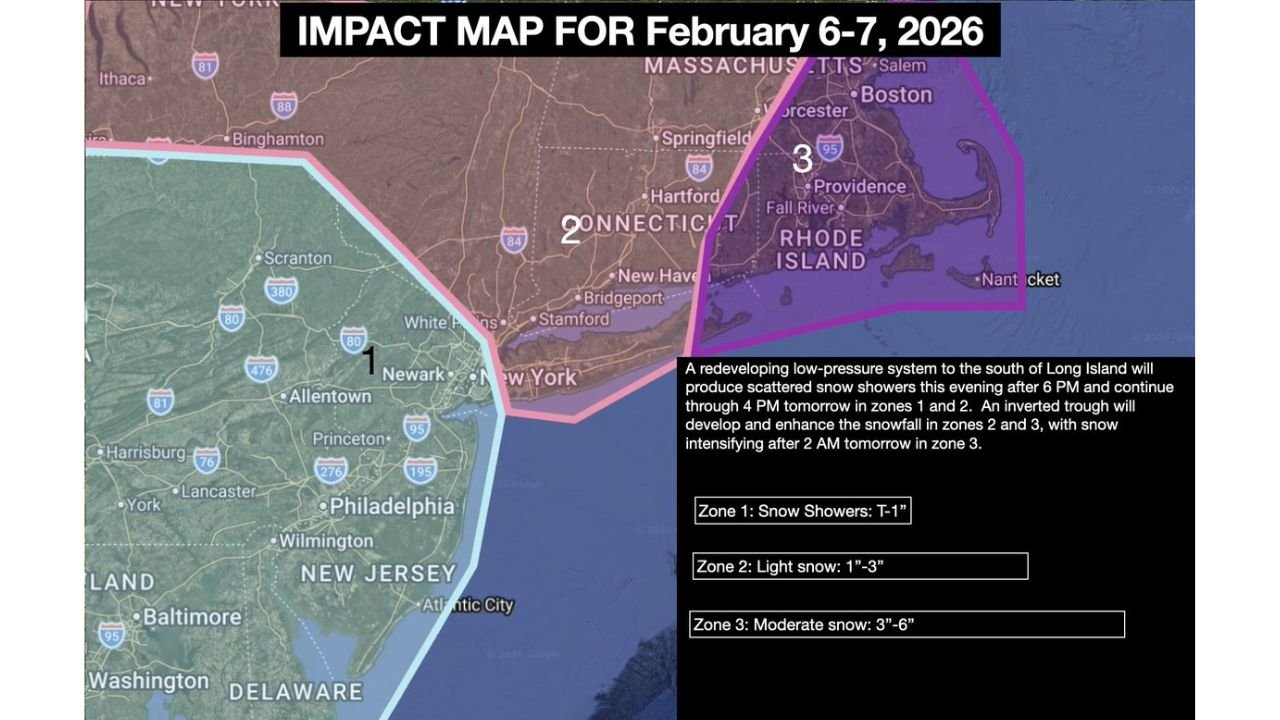
February 6–7 Snow Impact Map Flags New Jersey, Connecticut, Rhode Island and Massachusetts for Uneven Snow Bands Overnight Into Saturday
UNITED STATES — A new Public Impact Map for February 6–7, 2026 breaks the storm into three snowfall zones from the Mid-Atlantic into Southern New England, warning that a redeveloping low-pressure system south of Long Island could produce scattered evening snow, then a more organized, band-enhanced push overnight into Saturday, with totals ranging from a coating to 6 inches depending on where the heaviest band sets up.
What the Impact Map Is Highlighting
The map outlines a redevelopment setup: low pressure to the south of Long Island helps keep snow going, while an inverted trough is expected to form and enhance snowfall in Zones 2 and 3. That enhancement is the main reason totals can jump quickly in a narrow corridor, even if nearby towns stay much lower.
The map was updated 2/06/26 at 6:47 AM, reflecting the latest short-range thinking for tonight through Saturday.
Timing: When Snow Starts and When It Peaks
The timeline on the map calls for:
- After 6 PM Friday: scattered snow showers develop this evening
- Through 4 PM Saturday: snow continues through much of Saturday in Zones 1 and 2, though intensity can vary
- After 2 AM Saturday: snow is expected to intensify in Zone 3, where banding could push totals higher
This is the kind of setup where the overnight period matters most—especially where bands lock in for a few hours.
Zone 1: New Jersey and the Philadelphia Area
Zone 1 (Snow Showers: T–1″) covers much of New Jersey and the corridor that includes areas near Philadelphia and Wilmington.
What that means in real life:
- Mostly nuisance-level accumulation (a coating to around 1″)
- Still enough for slick bridges, ramps, and untreated side roads
- Bursts could briefly reduce visibility, but widespread heavy snow is not the main expectation in this zone
Zone 2: Connecticut’s Core Snow Band Risk
Zone 2 (Light snow: 1″–3″) is centered over Connecticut, including the Hartford-to-coastal corridor (with cities like Hartford, New Haven, Bridgeport, Stamford shown in the zone).
What to watch:
- A steadier period of light snow is possible overnight into Saturday
- Totals are forecast in the 1–3 inch range, but the edge of any heavier band could raise or lower totals sharply depending on exact placement
- Travel impacts are most likely early Saturday, especially where snow overlaps with colder air and gustier winds
Zone 3: Massachusetts, Rhode Island and Coastal “Enhancement”
Zone 3 (Moderate snow: 3″–6″) includes Rhode Island and parts of Massachusetts, including areas near Providence, Boston, Worcester, and out toward Cape Cod/Nantucket on the map.
This is the zone with the biggest upside because the map specifically mentions:
- The inverted trough enhancing snow in Zones 2 and 3
- Intensification after 2 AM Saturday in Zone 3
What that could look like:
- Periods of moderate snow, especially pre-dawn into the morning hours Saturday
- Localized heavier bursts if a narrow band sets up over the same area for several hours
- Visibility dropping quickly during the strongest bursts, especially near the coast and into eastern sections
Why This Can Be “Feast or Famine” Snow
Impact maps like this are often used when forecasters see a pattern where totals can swing hard over short distances. The key culprit here is the expected banding tied to the inverted trough.
If you’re in or near the boundary between zones, totals can change dramatically from one town to the next:
- One community gets a quick 4–6″
- Ten miles away ends up with 1–2″
- Another spot sees mostly flurries and a coating
That’s why the zone approach matters more than any single “one-size” total.
What This Means for Travelers and Weekend Plans
If you’re traveling Friday night into Saturday across New Jersey, Connecticut, Rhode Island, or Massachusetts, plan for:
- Patchy slick roads even in the lowest-impact zone
- A higher chance of snow-covered stretches in Connecticut
- The greatest risk for fast accumulation and reduced visibility in Rhode Island and eastern/central Massachusetts, especially after 2 AM Saturday
Conditions can also change quickly as the storm evolves, so the most important move is checking how banding is actually setting up overnight.
If you’re in any of these zones, what are you seeing after sunset—light snow, steadier flakes, or nothing yet? Share what’s happening where you are, and keep following CabarrusWeekly.com for more weather updates and map breakdowns.