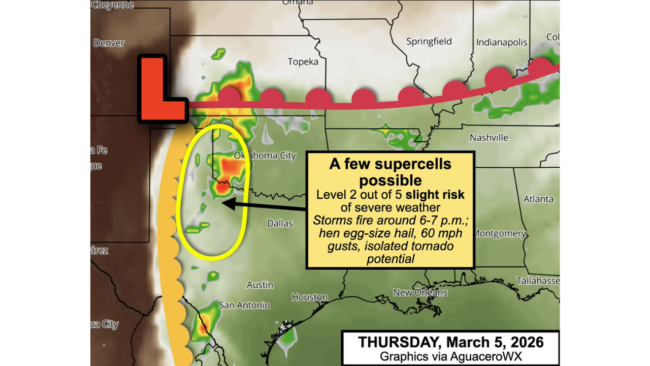
First Supercell Threat of the 2026 Season Targets Western Oklahoma and Texas Panhandle, Large Hail and 60+ MPH Winds Possible Thursday Evening
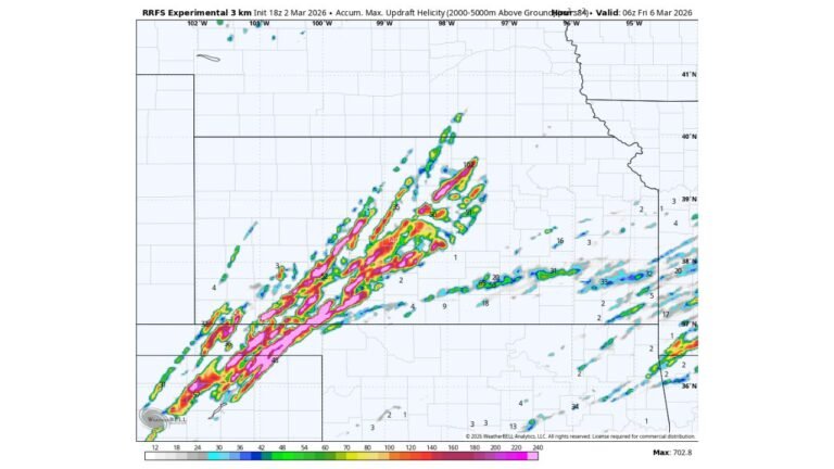
WESTERN OKLAHOMA & TEXAS PANHANDLE — Thursday, March 5, 2026 could mark the season’s first organized batch of widely scattered supercells across the southern Plains, with severe storms expected to develop late in the day and intensify into the evening.
Forecast guidance indicates a Level 2 out of 5 “Slight Risk” of severe weather, centered primarily over western Oklahoma, the Texas Panhandle, and nearby portions of the Caprock region.
Cities Included in the Risk Area
Communities that may see storm development include:
- San Angelo
- Abilene
- Snyder
- Big Spring
- Guthrie
- Childress
- Crosbyton
- Memphis
- Pampa
- Sayre
- Erick
- Elk City
- Lawton–Fort Sill
- Clinton
Storms are expected to begin firing around 6 to 7 p.m., particularly near the sharpening dryline boundary.
Main Hazards: Large Hail and Strong Wind Gusts
The primary concerns with this setup are:
- Golf-ball to hen egg-sized hail
- Wind gusts exceeding 60 mph
- An isolated tornado cannot be ruled out
While tornado risk appears limited compared to hail and wind, rotating supercells may briefly develop before storms merge.
Dryline Clash to Spark Storms
The setup centers around strengthening low pressure in southeast Colorado, which will sharpen the dryline — the dividing line between dry desert air to the west and moisture-rich Gulf air to the east.
As that clash intensifies Thursday evening:
- Warm, unstable air east of the dryline will fuel updrafts.
- Winds increasing with height may allow storms to rotate.
- Early discrete supercells could form before transitioning into clusters.
Why Tornado Risk Is Limited
Although wind shear will be present, winds about a mile above the surface are forecast to blow largely parallel to the boundary rather than perpendicular.
That configuration may prevent storms from fully detaching from the dryline and maintaining classic long-lived supercell structures. Instead:
- Storms may ride along the boundary.
- Cells could merge into messy clusters or lines.
- Hail and damaging winds become the dominant threats.
This storm evolution lowers — but does not eliminate — the tornado potential.
A Sign the Severe Season Is Starting
This event could represent the first organized severe weather episode of the 2026 season across the southern Plains.
Early March often marks the transition into peak severe weather season for Oklahoma and Texas. Even if Thursday’s threat remains scattered, it signals that the atmospheric pattern is becoming more supportive of springtime storm development.
What This Means for North Carolina
While this threat is focused on the southern Plains, Cabarrus County residents know that severe season gradually shifts eastward as spring progresses.
Systems that begin in Texas and Oklahoma often influence downstream weather patterns days later across the Southeast.
CabarrusWeekly.com will continue monitoring national severe weather setups as the 2026 storm season begins to take shape.