Florida and Georgia Including Tallahassee, Albany and Bainbridge Set for First 90 Degree Heat Surge of 2026 After Brief Cooldown
FLORIDA — A stretch of early spring warmth is about to intensify into what could be the first widespread 90-degree heat of 2026, following a brief cooldown early in the week.
Warm Start Before Midweek Cooldown
The forecast shows Sunday and Monday staying warm, with many areas already pushing into the 80s across the Florida Panhandle and southern Georgia.
Cities such as:
- Tallahassee, Florida
- Albany, Georgia
- Bainbridge, Georgia
- Dothan, Alabama
are all expected to remain well above average for late March.
However, a cold front moving through Tuesday will temporarily knock temperatures back into the 60s and 70s, offering a short-lived break from the heat.
Rapid Temperature Rebound Late Week
That cooldown won’t last long.
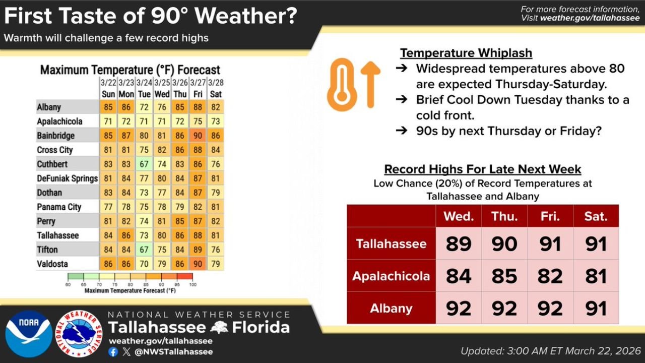
By Wednesday through Saturday, a strong ridge of high pressure is expected to build over the region, triggering a sharp warm-up once again.
Forecast highs show:
- Upper 80s by Wednesday
- Near 90 degrees Thursday and Friday
- Continued warmth into Saturday
This quick shift from warm → cooler → hot is a classic example of springtime “temperature whiplash.”
First Real Shot at 90 Degree Temperatures
The most notable part of this forecast is the potential for widespread 90-degree readings, especially in:
- Tallahassee: 89° (Wed), 90° (Thu), 91° (Fri & Sat)
- Albany: 92° for multiple days late week
- Bainbridge and surrounding inland areas nearing 90°+
If these numbers hold, this would mark the first significant 90-degree heat event of the year for parts of the Southeast.
Record Highs Could Be Challenged
While not guaranteed, there is a low-end chance (around 20%) that some daily temperature records could be tied or broken, particularly in:
- Tallahassee, Florida
- Albany, Georgia
These cities will be closest to the core of the heat ridge, where the warmest air will settle.
Coastal Areas Slightly Cooler but Still Warm
Locations closer to the coast, such as Apalachicola and Panama City, will remain slightly cooler due to marine influence, but even these areas are expected to reach:
- Low to mid 80s late week
That still represents above-average warmth for late March.
What’s Driving This Heat Surge
The key factor behind this pattern is a strong upper-level ridge of high pressure, which will:
- Suppress cloud formation
- Increase sunshine
- Allow temperatures to climb efficiently each afternoon
Combined with already warm ground conditions, this setup supports rapid heating.
What to Expect Going Forward
Residents should prepare for:
- Increasing heat late in the week
- Large day-to-day temperature swings
- Early-season warmth that may feel more like late spring or early summer
Hydration, outdoor planning, and heat awareness become more important as temperatures approach the 90-degree mark.
Final Outlook
After a brief midweek cooldown, Florida and Georgia are on track for their first true taste of summer-like heat, with multiple days near or above 90 degrees by the end of the week.
Stay with CabarrusWeekly.com for continued updates as this early-season heatwave develops across the Southeast.