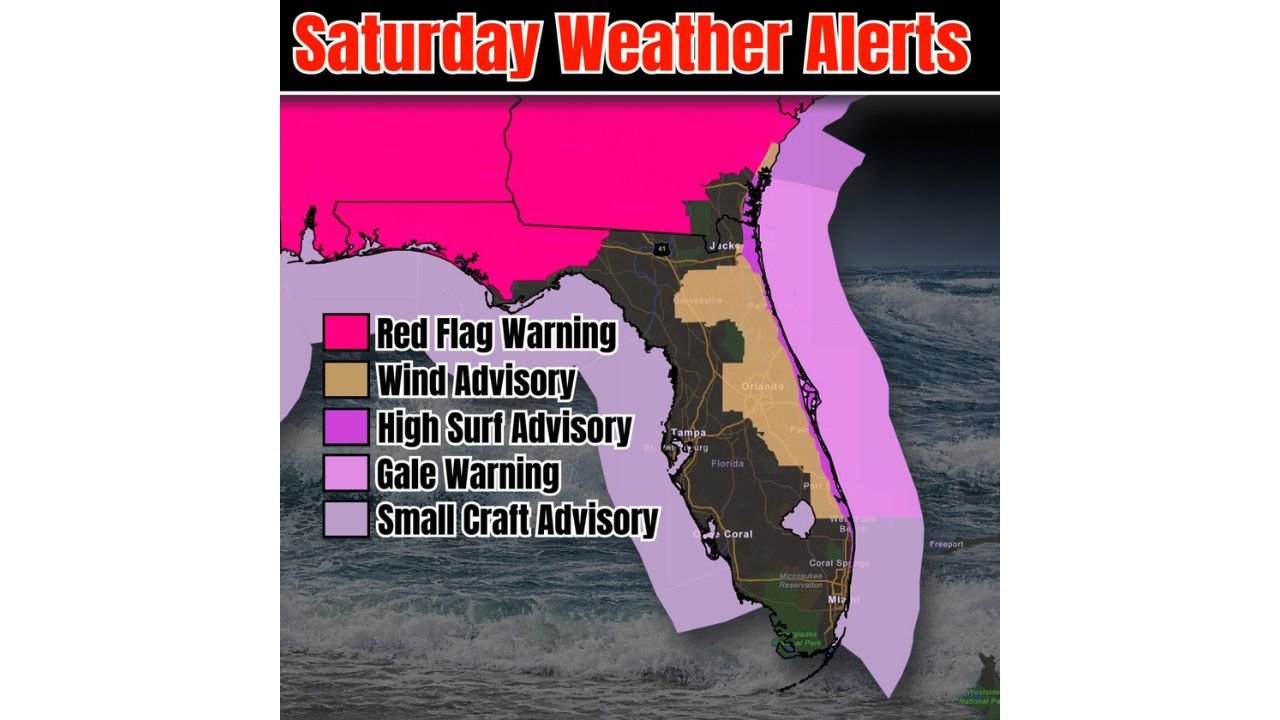
Florida Faces Multiple Weather Alerts Saturday Including Red Flag Warning, Gale Warning, High Surf Advisory, and Wind Advisory From Jacksonville to Miami
FLORIDA, UNITED STATES — Saturday is shaping up to be one of the most active weather days of the season across Florida. A cool front pushing across the state is setting off a chain of alerts spanning from the Panhandle to South Florida — covering wildfire danger, dangerous surf, gale-force offshore winds, and strong inland gusts all at the same time.
Here is a breakdown of every alert in effect Saturday and what it means for residents across the state.
Red Flag Warning — North Florida and the Panhandle
The cool front is driving extremely dry conditions into northern Florida and the Panhandle, where a Red Flag Warning is in effect Saturday. This is the highest fire weather designation — it means winds and low humidity are combining to create conditions where any fire that starts can spread rapidly and become difficult to control.
Residents across the Panhandle and North Florida should avoid all outdoor burning Saturday. Even a small spark from equipment, a vehicle, or a discarded cigarette can ignite dry vegetation under these conditions. Pollen levels are also running high statewide, adding to the already hazy and irritating air quality across the region.
Wind Advisory — Central Florida Peninsula
A Wind Advisory covers a large swath of the central Florida peninsula from the Jacksonville area southward through Orlando, Tampa, and into South Florida. This means sustained winds and gusts strong enough to make driving difficult, blow over unsecured objects, and create hazardous conditions outdoors.
Residents should secure anything that could become airborne — patio furniture, trash bins, potted plants, and outdoor decorations are all at risk. Drivers of high-profile vehicles, trucks, and RVs should use extra caution on open highways and causeways Saturday.
High Surf Advisory and Gale Warning — Atlantic Coast
The strongest impacts Saturday are along Florida’s east coast. Atlantic winds flowing in from the east are generating dangerous wave heights along the entire east-facing shoreline, from Jacksonville Beach down through Palm Beach. A High Surf Advisory means waves are large enough to knock people down, generate powerful rip currents, and make swimming extremely dangerous.
A Gale Warning is in effect for offshore Atlantic waters, with gusts reaching 52 mph in open ocean areas. Anyone on the water off the east coast Saturday is in serious danger — all recreational boating should be suspended until the warning is lifted.
Small Craft Advisory — Gulf and Surrounding Waters
Gulf waters and surrounding marine areas are under a Small Craft Advisory Saturday. While conditions on the Gulf side are less severe than the Atlantic, they are still dangerous for smaller vessels. Boaters on the Gulf should monitor conditions closely and consider staying ashore through the weekend.
Forecast Confidence Level
High confidence on all active alerts — the cool front position and associated wind field are well-established in the forecast and consistent across all data.
High confidence on Red Flag Warning conditions for the Panhandle — dry air behind the front is locked in for Saturday.
High confidence on Gale Warning and High Surf conditions for the Atlantic coast — easterly winds at these speeds are generating hazardous marine and beach conditions through the day.
What Florida Residents Must Know Saturday
Stay off all Atlantic beaches. High surf and rip currents make swimming and wading genuinely life-threatening Saturday. Even wading in shallow water near the shoreline carries serious risk when surf is running this high.
Do not take any boat onto the Atlantic. Gale-force gusts offshore mean no recreational vessel should be on open water on the east side of the state Saturday.
Secure your home and property before Saturday morning. Wind gusts across the peninsula are strong enough to send outdoor objects airborne across central and south Florida.
North Florida and Panhandle residents must avoid all outdoor burning. The Red Flag Warning means fire conditions are at their most dangerous — one ignition source is all it takes for a fire to escape control quickly.
Allergy sufferers take note — pollen is forecast to be flying statewide Saturday behind the front. Those with respiratory sensitivities should limit time outdoors and keep windows closed.
The Bottom Line
Florida is facing a rare multi-alert Saturday driven by a single cool front. The Panhandle is under a Red Flag Warning for wildfire danger. The central peninsula is under a Wind Advisory. The Atlantic coast faces a Gale Warning and High Surf Advisory. And Gulf waters carry a Small Craft Advisory. Every region of the state is affected in some way — check your local alerts before heading outside Saturday.
Stay ahead of dangerous weather before it reaches your door. Visit cabarrusweekly.com for daily storm alerts, wind advisories, and weather updates from across the United States — because knowing early is the difference that matters.